
Where: There's a street sign on the left:

Duddell Street, so we're looking west along Queen's Road Central from near the junction with Ice House Street.
What: Here are the buildings in the foreground:

From left to right:
Buildings B and C are the oldest of the group. Note how they run right up to the edge of the road, providing a covered walkway for pedestrians.
Queen's Road dates back to the start of the British colony, and was originally much narrower than it is today. Here's how this stretch of road looked in the late 1800s:

I believe the government had a policy that whenever a site was re-developed, the new building had to be set back to allow the road to be widened. At least that's what we see in the photos, though I haven't seen the policy written down.
When: The buildings give us a rough idea. The newest building is E, Edinburgh House. It was finished in 1950, so the photo must be at least as old as that.
Next come the two cars. On the left is registration number 4422:

We can't see the full registration number of the car on the right, but it starts with an H:

The "HK ????" series of registration numbers was launched in 1951 [1], so we must be later than that.
The other clue comes from 8, Queen's Road Central. In this photo, taken in 1954, the building has been demolished:
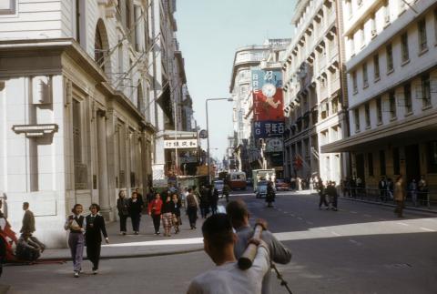
So our photo was likely taken around 1952-3.
Who: The street looks busy, and originally I thought it was the lunchtime crowd. But looking off in the distance is that a clock beneath the sign for CYMA, a watch brand:

I can't be sure if it is a real clock or just an advertising photo:

If it is real, the time is around five past ten in the morning. That looks about right for the shadows so it isn't lunchtime yet, just the usual business crowd.
If you have any questions or corrections, please let me know in the comments below. I'd also enjoy hearing any memories or stories about this area.
Regards, David
|
Also on Gwulo.com this week:
|
References:
- A timeline of car registrations: http://gwulo.com/node/15971
Comments
Duddell Street
Barbara Anslow writes:
The sign 'Duddell Street' rings a bell for me, as during the HK war I was billeted in a building there, Dina House, with other Air Raid Precautions staff. This was a convenient billet as we had meals at the nearby Parisienne Grill which was in a Street parallel to Duddell Street.
After the war we had a prewar car with the number something like 1008. As you say, later on the numbers all began with HK. Will hunt through photos to see if there is one showing the number of a different car we bought around 1949.
(The Parisienne Grill was still there when this photo was taken. Its "PG" sign is sticking out from behind number 8, QRC.)
Road-widening
David Mahoney writes:
If I remember correctly, road widening on redevelopment was facilitated by the operation of Building (Planning) Regulation 22(1) and 22(2).
The former allowed the area of the portion of the site to be surrendered for road widening to be added to the original site area and, by multiplying this by the appropriate plot ratio, arriving at the permitted gross floor area - the latter allowed the area to be surrendered to be added only to the remaining site.
This saved Government a lot of money in compensation.
Queen's Road Central in 1950s
My parents used to have a shop and office in On Lan Street behind Pacific House (12 Queen's Road Central ) between 1946 and 1972. I was born in 1950 and my memory of that stretch of Queen;s Road Central was just like the 1954 pic . I was too young to recall the old building of 8 Queen's Road Central. I was a children saving account holder of Woo Shing Bank which my Dad opened for me with an initial deposit of HK$10 ( a fortune to me) in mid to late 1950s