A path runs from Stanley Gap Road, a few hundred meters below its junction with Chung Hom Kok Road, up to the water catchment that runs around Stanley Mound above. It starts on the right of the "slow" sign painted on the road in the photo below. Although very short, there are a number of interesting features at the side of the path.
The path forks after a short distance. If you take the right fork it quickly becomes very overgrown and comes to a partly demolished military bunker.
I'm not sure if this is one of the standard issue, pre-WWII built, bunkers. The door looks a bit narrower than the norm. The interior has been tiled, presumably by post-war squatters.
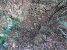
Retracing your steps to the fork in the path and continuing uphill takes you past two holes on the left of the path. One's not very obvious.
But the other's a bit more distinct.
Their both definately man-made, but in view of their lack of features its difficult to know why they were dug. Considering what lies a short distance above, perhaps they were fox-holes, i.e. small miliitary trenches?
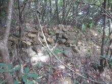
Further up the path, a few meters below the water catchment and just visible on the left through the undergrowth, is a far more substantial trench.
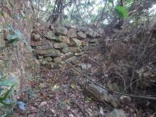
It's at least a meter deep, 1 1/2 to 2 meters across and perhaps ten meters long, with a dry stone wall dividing it in two across the middle. The above photo is the view from the side nearest the path, and here's the other half.
A close-up of the dry stone wall shows it's built up to the level of the rim of the trench, preventing movement between the two halves. I wonder what function the wall served? If it was a military trench an obvious disadvantage is that anyone moving from one side to the other must expose themselves above the lip of the trench.
Dropping down the slope in front of the trench reveals that rocks have been piled up along its front. Again assuming this was a military bunker, perhaps the idea was to make a frontal attack more difficult.
Today the view from the trench is completely obscured by trees, but I'm fairly sure it faces down Stanley Gap Road towards Stone Hill. I can't think of any reason for digging it other than as a military trench. If so, then it was probably built just before WWII to cover Stanley Gap Road. Grateful for any information from anyone who knows differently...although I'll look a bit stupid if it turns out the trench was dug by schoolboys as a school project!
Comments
Path from Stanley Gap Road to water catchment above
A path runs from Stanley Gap Road, a few hundred meters below its junction with Chung Hom Kok Road, up to the water catchment that runs around Stanley Mound above. It starts on the right of the "slow" sign painted on the road in the photo below. Although very short, there are a number of interesting features at the side of the path.
The path forks after a short distance. If you take the right fork it quickly becomes very overgrown and comes to a partly demolished military bunker.
I'm not sure if this is one of the standard issue, pre-WWII built, bunkers. The door looks a bit narrower than the norm. The interior has been tiled, presumably by post-war squatters.
Retracing your steps to the fork in the path and continuing uphill takes you past two holes on the left of the path. One's not very obvious.
But the other's a bit more distinct.
Their both definately man-made, but in view of their lack of features its difficult to know why they were dug. Considering what lies a short distance above, perhaps they were fox-holes, i.e. small miliitary trenches?
Further up the path, a few meters below the water catchment and just visible on the left through the undergrowth, is a far more substantial trench.
It's at least a meter deep, 1 1/2 to 2 meters across and perhaps ten meters long, with a dry stone wall dividing it in two across the middle. The above photo is the view from the side nearest the path, and here's the other half.
A close-up of the dry stone wall shows it's built up to the level of the rim of the trench, preventing movement between the two halves. I wonder what function the wall served? If it was a military trench an obvious disadvantage is that anyone moving from one side to the other must expose themselves above the lip of the trench.
Dropping down the slope in front of the trench reveals that rocks have been piled up along its front. Again assuming this was a military bunker, perhaps the idea was to make a frontal attack more difficult.
Today the view from the trench is completely obscured by trees, but I'm fairly sure it faces down Stanley Gap Road towards Stone Hill. I can't think of any reason for digging it other than as a military trench. If so, then it was probably built just before WWII to cover Stanley Gap Road. Grateful for any information from anyone who knows differently...although I'll look a bit stupid if it turns out the trench was dug by schoolboys as a school project!