There's an old path up to this clearing, which contains two buildings. One is possibly post-war, some sort of waterworks quarters or offices. Now boarded up. The other, more interesting building solely contains the old stone foundations. With big cellar-type arches, the building appeared to have been a brickworks and possibly dates back to the early 1900s. The structure appears to have been pulled down/fallen down and the granite blocks and iron supports from the building are stacked up nearby, being slowly lost to the jungle. There was also a curious concrete lined pit, I assume for water ro some kind of mixing, with a concrete obilisk in the middle. No markings. You can see all the red bricks stacked up inside the archways.
Can't find any history of this, I wonder if there's any photos or memories of this building.
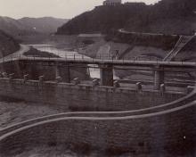
I've linked in a photo that I think shows the buildings you describe.
If you follow the catchwater that runs from the reservoir round towards Repulse Bay, at one point there's a concrete path heads off to the left. Is that the one that leads up to this clearing? I've often thought it looked interesting, but haven't checked it out.
Hi David - that may well connect but I'm not sure - I climbed down the ladder to the river bed just beyong the dam wall shown in your picture and up the other side. There's a path that takes you from there.
Those are definitely the right buildings. Thanks alot for finding that. I wonder when the brickworks (if indeed that's what the building was) fell down/was pulled down. A shame, could have been a good part of the overall waterworks trail. I think today it is too hard to get to, for the govt to bother with it.
The building on the left in the old photo was the ‘Tai Tam Bungalow’, as it was so named in the 1939, 1:20,000 OS Map, Sheet No.19.
It’s of historic significance as it was here that Captain Penn and No. 1 Coy, HKVDC took up position at dawn on 19-12-1941 having earlier been overrun by the Japanese at Quarry or Sanatorium Gap. Penn refers to it as the Tytam Bungalow in the HKVDC War Diary, and explains that he chose it because a telephone was installed therein and it offered a good view to the north, the direction from which the Japanese were advancing.
Based here they provided infantry cover for the HKSAR artillery at the Gauge Basin Mobile Artillery Battery on top of the hill, the lower slope of which is seen on the left of the old photo. Later on the morning of the 19th both the HKSAR and HKVDC detachments withdrew towards Stanley to avoid being outflanked by the advancing Japanese.
The ruins of the bungalow are accessible by the two routes described by 80s Kid and David. The top left corner of the old photo shows what seems to be a raised bridge above the wall or weir of the Byewash Reservoir. It’s no longer there, but I think it was the main access route to the bungalow back in the day.
I didn’t notice the concrete lined pit with the central obelisk described by 80s Kid during my visits to the bungalow site. I wonder if it’s another of the machine gun positions described elsewhere on Gwulo (node 6367)?
I have changed the name - the ruins were part of the grading for the Byewash Reservoir and were previously quarters for senior staff. I guess they used the ample basement as a brick storage area after it fell into disuse. The building next door are workmen's quarters, according to the government. This is from the AMO:
The Workmen’s Quarters (工人宿舍) and the ruins of the Senior Staff
Bungalow (高級職員宿舍遺址) are situated on the summit of a small hill to
the south-west of the dam. The ruins of the bungalow simply consist of some
steps, the granite foundations and the ground floor slab. The structural walls
have been demolished and pieces left scattered around the ruins. The
workmen’s quarters consist of a long narrow rectangular single-storey block
with red brick walls and a pitched roof of Chinese tiles. A brick privy is built on
to the south end. Door and window openings have simple concrete lintels. The
building is uninhabited, derelict and falling into ruin from lack of care and maintenance.
I'm not sure what the pit was used for but I'm guessing it was something water-related. the oblisik is of a decent size.
I've put the date of the construction of the byewash reservoir as the build date
80's Kid's post of 4-11-2013 above mentioned a curious pit with a column in it near the Tai Tam Bungalow. This is it;
And from the other side.
It's in the undergrowth infront of the south side of the Tai Tam Bungalow and consists of a sunken, circular, concrete pit, about three meters in diameter with a square concrete column rising from its centre.
A set of steps leads into the pit.
A metal ring, possibly the end of a pipe, tops the column.
I initially guessed that the metal ring was the end of a water pipe and the whole structure was a water fountain. However, after reading a few articles on the net about how fountains worked before the invention of the electic pump, I now doubt it.
Prior to electricity, water fountains worked either by gravity (requiring an airtight pipe from a water source at a higher level than the fountain creating sufficient pressure to emit water from the fountain) or a steam powered pump. As the bungalow sits on a hill, well above the level of the reservoirs, running water wasn't installed until 1918 (PWD Annual Report, 1918) and it would have been rather extravegant to install a steam pump for such a small fountain, neither seem likely.
The possibility of the pit being an ornamental pool, such as a fish or lily pond, also crossed my mind. Again I think not, as I couldn't see an overflow outlet, and building steps down into the water seems a bit pointless.
On balance I guess the concrete pit and column were just an ornamental base on which to mount some sort of decorative metalwork, perhaps a wind vane. Hopefully a photo will surface one day showing what the whole bungalow and this structure looked like originally. Presuming that when the structure was built, the surrounding vegetation was much lower than it is today, there would have been a great view down the valley towards Tai Tam Tuk.
Here are some photos I took during a visit in 1-2013. The remains of the bungalow consist of a platform, the top of which would have been the ground floor of the building, which now has debris piled up in the middle of it. That's the workmans accommodation in the distance.
The platform stands about 1.5m above the ground. From the western end there are two sets of stairs up to it, the narrower one for workers perhaps.
At the opposite end there's another staircase. This photo also shows how the structure stands on an outer and inner layer or arches.
On this side of the bungalow the cellars within the inner arches have been packed with bricks. Perhaps they were recovered during the demolition and stored with the intention of future use.
Elsewhere the cellars are empty.
Next door is the workmans accommodation or store, a long oblong shaped building with an awning extending from its front.
And here's the back of it.
An interesting historical site, although a bit spooky, hidden and forgotten within the trees.
A bit late to the party, but we went along for a look this morning. We took the path that leads from the catchwater at the bottom-left of this map. (The shaded rectangle is the workmen's quarters, and the dashed square outline above it marks the location of the bunaglow.)
It's a clear, concrete path, an easy walk. Here's the first view of the workmen's quarters:
And the view in through a window:
Otherwise it looks the same as in the earlier photos.
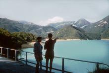
I was wondering whether one of the slopes from this hilltop would have their old rubbish heap (think old bottles, etc), but any thoughts of exploring vanished when my wife pointed out this sleepy fellow:
By zooming in to the maximum on the area above the head of the pointing man, both the Tai Tam Bungalow (right) and the Workmans Quarters (left) are seen on the lower of the two distant ridge lines. As the photo was taken in 1958, demolishion date of the Bungalow must have been sometime since then.
Comments
re Tai Tam Brickworks
There's an old path up to this clearing, which contains two buildings. One is possibly post-war, some sort of waterworks quarters or offices. Now boarded up. The other, more interesting building solely contains the old stone foundations. With big cellar-type arches, the building appeared to have been a brickworks and possibly dates back to the early 1900s. The structure appears to have been pulled down/fallen down and the granite blocks and iron supports from the building are stacked up nearby, being slowly lost to the jungle. There was also a curious concrete lined pit, I assume for water ro some kind of mixing, with a concrete obilisk in the middle. No markings. You can see all the red bricks stacked up inside the archways.
Can't find any history of this, I wonder if there's any photos or memories of this building.
re: Tai Tam Brickworks
I've linked in a photo that I think shows the buildings you describe.
If you follow the catchwater that runs from the reservoir round towards Repulse Bay, at one point there's a concrete path heads off to the left. Is that the one that leads up to this clearing? I've often thought it looked interesting, but haven't checked it out.
Regards, David
re: Tai Tam Brickworks
Hi David - that may well connect but I'm not sure - I climbed down the ladder to the river bed just beyong the dam wall shown in your picture and up the other side. There's a path that takes you from there.
Those are definitely the right buildings. Thanks alot for finding that. I wonder when the brickworks (if indeed that's what the building was) fell down/was pulled down. A shame, could have been a good part of the overall waterworks trail. I think today it is too hard to get to, for the govt to bother with it.
Tai Tam Bungalow
The building on the left in the old photo was the ‘Tai Tam Bungalow’, as it was so named in the 1939, 1:20,000 OS Map, Sheet No.19.
It’s of historic significance as it was here that Captain Penn and No. 1 Coy, HKVDC took up position at dawn on 19-12-1941 having earlier been overrun by the Japanese at Quarry or Sanatorium Gap. Penn refers to it as the Tytam Bungalow in the HKVDC War Diary, and explains that he chose it because a telephone was installed therein and it offered a good view to the north, the direction from which the Japanese were advancing.
Based here they provided infantry cover for the HKSAR artillery at the Gauge Basin Mobile Artillery Battery on top of the hill, the lower slope of which is seen on the left of the old photo. Later on the morning of the 19th both the HKSAR and HKVDC detachments withdrew towards Stanley to avoid being outflanked by the advancing Japanese.
The ruins of the bungalow are accessible by the two routes described by 80s Kid and David. The top left corner of the old photo shows what seems to be a raised bridge above the wall or weir of the Byewash Reservoir. It’s no longer there, but I think it was the main access route to the bungalow back in the day.
I didn’t notice the concrete lined pit with the central obelisk described by 80s Kid during my visits to the bungalow site. I wonder if it’s another of the machine gun positions described elsewhere on Gwulo (node 6367)?
thanks GW
I have changed the name - the ruins were part of the grading for the Byewash Reservoir and were previously quarters for senior staff. I guess they used the ample basement as a brick storage area after it fell into disuse. The building next door are workmen's quarters, according to the government. This is from the AMO:
The Workmen’s Quarters (工人宿舍) and the ruins of the Senior Staff
Bungalow (高級職員宿舍遺址) are situated on the summit of a small hill to
the south-west of the dam. The ruins of the bungalow simply consist of some
steps, the granite foundations and the ground floor slab. The structural walls
have been demolished and pieces left scattered around the ruins. The
workmen’s quarters consist of a long narrow rectangular single-storey block
with red brick walls and a pitched roof of Chinese tiles. A brick privy is built on
to the south end. Door and window openings have simple concrete lintels. The
building is uninhabited, derelict and falling into ruin from lack of care and maintenance.
I'm not sure what the pit was used for but I'm guessing it was something water-related. the oblisik is of a decent size.
I've put the date of the construction of the byewash reservoir as the build date
Tai Tam Bungalow
some pics here: http://www.wsd.gov.hk/en/education/history/the_legacy_of_waterworks/tai_tam_byewash_reservoir/index.html
Structure at Tai Tam Bungalow
80's Kid's post of 4-11-2013 above mentioned a curious pit with a column in it near the Tai Tam Bungalow. This is it;
And from the other side.
It's in the undergrowth infront of the south side of the Tai Tam Bungalow and consists of a sunken, circular, concrete pit, about three meters in diameter with a square concrete column rising from its centre.
A set of steps leads into the pit.
A metal ring, possibly the end of a pipe, tops the column.
I initially guessed that the metal ring was the end of a water pipe and the whole structure was a water fountain. However, after reading a few articles on the net about how fountains worked before the invention of the electic pump, I now doubt it.
Prior to electricity, water fountains worked either by gravity (requiring an airtight pipe from a water source at a higher level than the fountain creating sufficient pressure to emit water from the fountain) or a steam powered pump. As the bungalow sits on a hill, well above the level of the reservoirs, running water wasn't installed until 1918 (PWD Annual Report, 1918) and it would have been rather extravegant to install a steam pump for such a small fountain, neither seem likely.
The possibility of the pit being an ornamental pool, such as a fish or lily pond, also crossed my mind. Again I think not, as I couldn't see an overflow outlet, and building steps down into the water seems a bit pointless.
On balance I guess the concrete pit and column were just an ornamental base on which to mount some sort of decorative metalwork, perhaps a wind vane. Hopefully a photo will surface one day showing what the whole bungalow and this structure looked like originally. Presuming that when the structure was built, the surrounding vegetation was much lower than it is today, there would have been a great view down the valley towards Tai Tam Tuk.
Tai Tam Bungalow
Here are some photos I took during a visit in 1-2013. The remains of the bungalow consist of a platform, the top of which would have been the ground floor of the building, which now has debris piled up in the middle of it. That's the workmans accommodation in the distance.
The platform stands about 1.5m above the ground. From the western end there are two sets of stairs up to it, the narrower one for workers perhaps.
At the opposite end there's another staircase. This photo also shows how the structure stands on an outer and inner layer or arches.
On this side of the bungalow the cellars within the inner arches have been packed with bricks. Perhaps they were recovered during the demolition and stored with the intention of future use.
Elsewhere the cellars are empty.
Next door is the workmans accommodation or store, a long oblong shaped building with an awning extending from its front.
And here's the back of it.
An interesting historical site, although a bit spooky, hidden and forgotten within the trees.
Tai Tam Bungalow
A bit late to the party, but we went along for a look this morning. We took the path that leads from the catchwater at the bottom-left of this map. (The shaded rectangle is the workmen's quarters, and the dashed square outline above it marks the location of the bunaglow.)
It's a clear, concrete path, an easy walk. Here's the first view of the workmen's quarters:
And the view in through a window:
Otherwise it looks the same as in the earlier photos.
I was wondering whether one of the slopes from this hilltop would have their old rubbish heap (think old bottles, etc), but any thoughts of exploring vanished when my wife pointed out this sleepy fellow:
Regards, David
Tai Tam Bungalow
By zooming in to the maximum on the area above the head of the pointing man, both the Tai Tam Bungalow (right) and the Workmans Quarters (left) are seen on the lower of the two distant ridge lines. As the photo was taken in 1958, demolishion date of the Bungalow must have been sometime since then.