Thanks to Henry Ching for these notes:
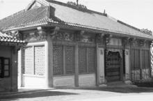
The Wing Pit Ting Pavilion was on Pokfulam Road, on the right hand side going up the hill towards the Queen Mary Hospital. It was on the outside curve of the road immediately past the University sports ground, south of and overlooking the old University sports pavilion in the south-east corner of the ground. The curve disappeared when Pokfulam Road was widened and put straight through to the south.
The original line of the road is still there - it runs past the sports grounds and playground. So I've put the marker about where the bend Henry describes was. That location also matches Thomas's estimate that the pavilion was opposite where the boundary stone is:
https://gwulo.com/node/13700#comment-24025
Regards, David
Photos that show this Place
Comments
Wing Pit Ting location
Dear David,
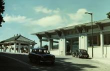
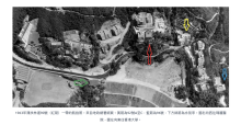
I have managed to retrieve a 1963 aerial picture of the area where the position of the Wing Pit Ting can be clearly identified in relation to the old Pokfulam Road, the HKU Lindsay Ride Sports Center and the HKU St John's college.I also found a 1970 picture taken at the HKU Sports Centre where the its location can be clearly seen at the South east end of the sports field (both pictures uploaded under the subject Wing Pit Ting).
The Boundary Stone can still be found on the opposite side of the road after the road was straightened. It can be found in today's Google map.
I graduated from HKU in 1981 and suspected the Wing Pit Ting must have been demolished before 1978.
re: Wing Pit Ting location
Thanks Freddie, I've nudged the marker to the location shown on the aerial photo you've added.