Thanks! I cannot see any belcony built on the Peak Hotel as shown on the following website. May be on the side facing south where Mount Kellett located.
I took a photo from the used to be Mountain Lodge a few months ago, now called the Victoria Peak Garden Top, compare my photo to the Klaus's photo (1910s) posted side by side, and to the Findlay's photo background, I think the photo location was somewhere in the Mount Austin(Mountain Lodge?).
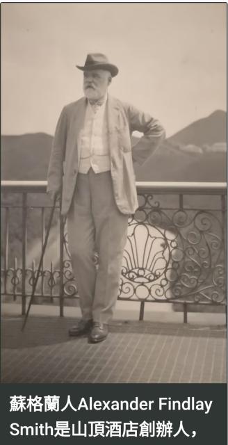
Is that a passing cloud below Findlay-Smith? The photo may well have been taken at a higher elevation. That being said, photos of Mountain Lodge also show a balustrade. At this juncture, I am not sure of the location of the photographer.
I don't think the angle or elevation match...enough. Note the small hillock on the far left of the older image sits a little proud of the ridgeline but is absent from the modern comparison. This means your modern image is too high in elevation. Also note the distant hillside on the right doesn't line up - so I think the modern location equivalent would be more to the left (i.e. east) of your recent image. I think the old Peak Hotel is a more likely place for the image to have been taken.
Thank you. I almost exhausted with new idea.... why don't we have a cup of Earl Grey inside the 1912 Peak Hotel (should it be 4-story?) first and explore some more angle and elevation later ....
Looking at the cross-referencing of the Mt Kellet area structures done by Klaus here: https://gwulo.com/media/54175, it looks as though the large building on the right of frame corresponds to the Des Voeux Villas houses marked 7/6. This structure in turn corresponds with today's "Harmony" development. If you look closely in the image of Mr Smith, you can see that the structure is directly under the peak of Mt Kellet.
If you line up "Harmony" under the Mt Kellet peak today (or at least where the peak should be), you will find it corresponds with a line of sight that runs from the Peak Hotel area. I had also briefly considered that Mr Smith might be standing on the terrace of the Peak Cafe, but then I would expect to see Peak Road on the left, so I feel that the hotel is more likely, or at least a building near to it.
Edit: There's also this image of three women and it looks like the railings behind them (by the shoulder of the left hand side woman) has the same circular pattern. It might just be my eyes though as it's late.
Mt K from Victoria Peak lookout pt - 2026, by h9430500
Dear Philk
Good point, agreed the photo location might be another building than the Peak Hotel.
I lived in the Barker Road on and off for 10+ years, and getting off the Peak Tram Upper Terminus almost every weekday. Line of sight in these area almost my instinct.
If the photo location was the Terrace of Peak Hotel, the Mt Kellett would very likely be more or less on his right-hand side (not his left-hand side by that far) and would be same or above, not below his eye level by that far.
I looked at many old photos in Gwulo, those old cameras, they weren't that good at all.
The balustrade, kind of blur, not for sure.
Some interesting facts about balcony popularities in the Victoria Peak buildings.
In older houses and heritage estates on the Victoria Peak, prominent outdoor balconies were historically rare.
The older colonial architecture primarily utilized verandahs (wide, covered, wrap-around ground-level porches) rather than open, projecting balconies.
Several key factors explain this design choice:
Typhoon and Rain Protection: Open balconies were highly vulnerable to Hong Kong’s violent seasonal typhoons and heavy monsoons.
Historical Segregation: Early European residents built heavily guarded "bungalows" or mansions to escape urban diseases and heat.
Winter and Fog Insulation: The Peak experiences high winds, dramatic temperature drops, and thick, persistent fog during the winter and spring.
Enclosed layouts or deep verandahs were far better at regulating interior climates than projecting balconies
The Peak Galleria should be taller than the Peak Hotel, even on top of the Peak Tower, the view towards Mt. K in this photo, would Mr. Smith's eye level be above the top of Mt. K by that much ? We ought to try it somehow.....
From the bottom of the photo, the place where Mr. Findlay-Smith is standing is at similar level (i.e. altitude, but in less quantitative sense) as the building in the far right close to Mount Kellett, i.e. in the area of “Harmony” as mentioned by philk.
To compare with other far objects in the photo as Mt. Kellett, the apparent size of Mr. Finlay-Smith’s figure depends more significantly on his relative position with the camera. So may need extra references on top of that.
Thank you for Mr. Kwok's point which came across my mind, the relative angle of the camera did matter. In this case, the camera angle was dead square on Mr. Simth's stomach.
Mount Kellett has an altitude of 501 metre, Mount Austin (Victoria Peak) stands at 552 metre.
The Peak Tower Sky Terrace sits at an elevation of about 396 metre.
The Peak Galleria roof top is about 10m below, say 386 metre.
Now if everything square, what would Mr. Smith eye level be in term of the altitude level ?
Develop photo in a dark room
It also occured to me alot of the old photos were somewhat off scale on objects, having been into a dark room developed student level photos, sometimes photo came off obscured because of immature process which I have experienced in the early 70s.
Comments
Photo Location
Taken from the terrace of the Peak Hotel (2nd Generation) or Ligoniel ?
Photo Location
Dear moddsey,
Thank you for a great question, my wild guess is the Ligoniel, the peak in the background looks like the Victoria Peak to me in that direction.
The balcony balustrade looks like the Ligoniel.
What do you think?
https://simple.wikipedia.org/wiki/Victoria_Peak
Re: Photo Location
I think one is looking at Mount Kellett, the pointy hill on the right. Cameron Villas below ?
A photo of Ligoniel shows a different ironwork floral pattern: https://search.grs.gov.hk/en/searchlib.xhtml?q=ligoneil&rpp=10
The photo may have been taken from the terrace of the Peak Hotel ? Some of the terraces of the Peak Hotel had iron railings with a floral pattern.
Peak Hotel - balcony balustrade
Thanks! I cannot see any belcony built on the Peak Hotel as shown on the following website. May be on the side facing south where Mount Kellett located.
https://www.hongkongheritage.org/nodes/view/20381
1920s Peak Hotel, Facing Mount Kellett
From balustrade to metal railings. Unfortunately, the tiled flooring in the main photo is not apparent.
Re: Photo Location side by side 1
For sure in the background was Mount Kellett. But where it was shot?
Re: Photo Location side by side 2
I took a photo from the used to be Mountain Lodge a few months ago, now called the Victoria Peak Garden Top, compare my photo to the Klaus's photo (1910s) posted side by side, and to the Findlay's photo background, I think the photo location was somewhere in the Mount Austin(Mountain Lodge?).
It seems to be the right angle and elevation.
Re: Photo Location
Is that a passing cloud below Findlay-Smith? The photo may well have been taken at a higher elevation. That being said, photos of Mountain Lodge also show a balustrade. At this juncture, I am not sure of the location of the photographer.
angle/elevation
I don't think the angle or elevation match...enough. Note the small hillock on the far left of the older image sits a little proud of the ridgeline but is absent from the modern comparison. This means your modern image is too high in elevation. Also note the distant hillside on the right doesn't line up - so I think the modern location equivalent would be more to the left (i.e. east) of your recent image. I think the old Peak Hotel is a more likely place for the image to have been taken.
Tea in the 1912 Peak Hotel
Dear philk,
Thank you. I almost exhausted with new idea.... why don't we have a cup of Earl Grey inside the 1912 Peak Hotel (should it be 4-story?) first and explore some more angle and elevation later ....
https://www.youtube.com/watch?v=pCXBCZUTqF0
Location
Looking at the cross-referencing of the Mt Kellet area structures done by Klaus here: https://gwulo.com/media/54175, it looks as though the large building on the right of frame corresponds to the Des Voeux Villas houses marked 7/6. This structure in turn corresponds with today's "Harmony" development. If you look closely in the image of Mr Smith, you can see that the structure is directly under the peak of Mt Kellet.
If you line up "Harmony" under the Mt Kellet peak today (or at least where the peak should be), you will find it corresponds with a line of sight that runs from the Peak Hotel area. I had also briefly considered that Mr Smith might be standing on the terrace of the Peak Cafe, but then I would expect to see Peak Road on the left, so I feel that the hotel is more likely, or at least a building near to it.
Edit: There's also this image of three women and it looks like the railings behind them (by the shoulder of the left hand side woman) has the same circular pattern. It might just be my eyes though as it's late.
More analysis on this photo.
Dear Philk
Good point, agreed the photo location might be another building than the Peak Hotel.
I lived in the Barker Road on and off for 10+ years, and getting off the Peak Tram Upper Terminus almost every weekday. Line of sight in these area almost my instinct.
If the photo location was the Terrace of Peak Hotel, the Mt Kellett would very likely be more or less on his right-hand side (not his left-hand side by that far) and would be same or above, not below his eye level by that far.
I looked at many old photos in Gwulo, those old cameras, they weren't that good at all.
The balustrade, kind of blur, not for sure.
Some interesting facts about balcony popularities in the Victoria Peak buildings.
In older houses and heritage estates on the Victoria Peak, prominent outdoor balconies were historically rare.
The older colonial architecture primarily utilized verandahs (wide, covered, wrap-around ground-level porches) rather than open, projecting balconies.
Several key factors explain this design choice:
Typhoon and Rain Protection: Open balconies were highly vulnerable to Hong Kong’s violent seasonal typhoons and heavy monsoons.
Historical Segregation: Early European residents built heavily guarded "bungalows" or mansions to escape urban diseases and heat.
Winter and Fog Insulation: The Peak experiences high winds, dramatic temperature drops, and thick, persistent fog during the winter and spring.
Enclosed layouts or deep verandahs were far better at regulating interior climates than projecting balconies
View of Mount Kellett from the Peak Galleria
2013 View of Mount Kellett from the Peak Galleria: Google Street View
Mr. Moddsey you are back !
The Peak Galleria should be taller than the Peak Hotel, even on top of the Peak Tower, the view towards Mt. K in this photo, would Mr. Smith's eye level be above the top of Mt. K by that much ? We ought to try it somehow.....
on elevation
From the bottom of the photo, the place where Mr. Findlay-Smith is standing is at similar level (i.e. altitude, but in less quantitative sense) as the building in the far right close to Mount Kellett, i.e. in the area of “Harmony” as mentioned by philk.
To compare with other far objects in the photo as Mt. Kellett, the apparent size of Mr. Finlay-Smith’s figure depends more significantly on his relative position with the camera. So may need extra references on top of that.
Sherlock Holmes’s moment
Thank you for Mr. Kwok's point which came across my mind, the relative angle of the camera did matter. In this case, the camera angle was dead square on Mr. Simth's stomach.
Mount Kellett has an altitude of 501 metre, Mount Austin (Victoria Peak) stands at 552 metre.
The Peak Tower Sky Terrace sits at an elevation of about 396 metre.
The Peak Galleria roof top is about 10m below, say 386 metre.
Now if everything square, what would Mr. Smith eye level be in term of the altitude level ?
Develop photo in a dark room
It also occured to me alot of the old photos were somewhat off scale on objects, having been into a dark room developed student level photos, sometimes photo came off obscured because of immature process which I have experienced in the early 70s.
What was the root cause of these?
Harmony - 72 Mount Kellett Road, The Peak
The GPS coordinates of 72 Mount Kellett Road at The Peak in Hong Kong are approximately 22.2618° N (latitude) 114.1495° E (longitude).
The elevation based on the above GPS is 427m.
The direct, straight-line distance between the Peak Galleria and Harmony - 72 Mount Kellett Road on Victoria Peak is approximately 850 meters.
The math is 386m high looking at Harmony at 427m high from a distance of 850m, and Mt K is 501m high, one can imagine the scenario.