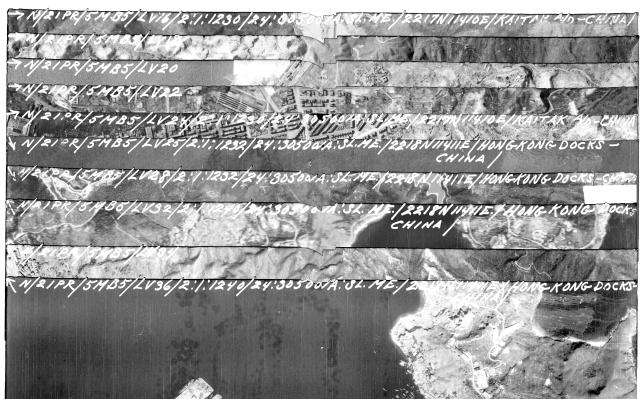
The aerial photos taken by American planes flying over Japanese-occupied Hong Kong in WW2 have a set of markings written across the top of the negatives. You can see several examples above. What do the different markings mean?
Craig Mitchell of Project Avenger mentioned this to his contacts in the U.S. military veteran community in Hong Kong, and they generously investigated. Here are their findings:
Regarding your question about WWII photo reconnaissance markings, below is our best guess based on internet sleuthing, our prior military experience, and what was typically written on negatives at that time. We're least confident about the italicized markings.
|
Marking
|
Meaning
|
Details
|
| ↑N | Orientation | Rotate the photo so the arrow points upwards (north) to align the photo. |
|
21PR
|
Unit
|
21st Photographic Reconnaissance Squadron [https://hpcbristol.net/photographer/21st-ssphotographic-reconnaissance-squadron-usaaf]
|
|
5MB5
|
Mission ID?
|
Maybe 5th mission for "MB5" series?
|
|
LV36
|
Camera/View
|
Left Vertical, Frame 36.
|
|
2:1:1240
|
Date & Time
|
February 1st at 12:40 PM
|
|
24
|
Focal length
|
24-inch lens
|
|
30500A
|
Altitude
|
30,500 feet.
|
|
SL.ME
|
Task Type?
|
Maybe "Shipping List - Military Establishments?"
|
|
2218N11411
|
Coordinates
|
22°18'N, 114°11'E.
|
| HONG KONG DOCKS | Items of interest |
We’re still scratching our heads over the "SL.ME" marking. Given the deep bench of history buffs that frequent your site, we’d be very curious to see if any of your readers have a better answer on what that stands for.
Date picture taken
1945