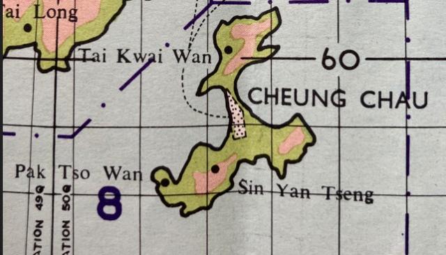
This cartographic representation of Cheung Chau 長洲 (Long Island) is a small section taken from the 1:100,000 scale map titled Hong Kong, Kowloon and the New Territories, which is included in the pocket on the back cover of: A Gazetteer of Place Names in Hong Kong, Kowloon and the New Territories, Government Press, Hong Kong 1960.
The Tai Long Peninsula region of South Central Lantau Island can be seen in the top left corner of the map.
Marked on the map, and described in the 1960 Gazetteer, are:
Tai Kwai Wan, on the northern part of Cheung Chau, is a small settlement on the bay.
Pak Tso Wan, on the south-west of the island, is a small settlement on the bay.
Sin Yan Tseng, on the south-central part of the island, is the western section of Cheung Chau Peak residential area.
The Gazetteer provides a general description of late 1950’s Cheung Chau in the following terms:
Cheung Chau is a small but busy island where the livelihood of the majority of its 15,100 inhabitants, who are mostly Cantonese, is mainly centred around the fishing industry and its related trades. The island has an area of 0.925 square mile. The western bay of the island affords sheltered anchorage for hundreds, often thousands, of native fishing craft ranging from the smallest sampan to the largest of ocean-going junks. Everything connected with the fishing industry from hook making to junk building is to be found in the island; other industries, again connected with the fishing industry, are those handling the processing of fisheries’ products. There are also other trades not connected with fishing, such as fruit and vegetable preserving and soy sauce manufacture.
The island is provided with a piped water supply (by undersea mains from Lantau Island) and electric current. There is a police station which maintains contact with Police Headquarters in Hong Kong; there are two hospitals.
The central sector is densely populated whilst much of the southern half of the island, often called the Peak or Cheung Chau Peak, is occupied by European-style residences; in contrast the northern half of the island, which is conspicuously barren and subject to soil erosion, is almost uninhabited except for small farming settlements in the low-lying areas of two of the bays. Small patches of cultivation are found here and there on the island.
There are several popular bathing beaches on the island, which is served by ferries from Hong Kong Island throughout the day, the trip taking about an hour each way. The old name of Dumbbell Island for Cheung Chau is seldom if ever used nowadays.