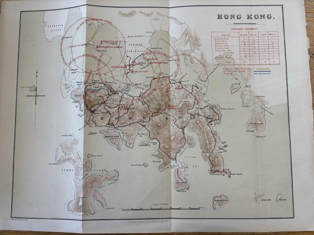
Given the pattern of folds, it would seem to have come from something like a book into which it had been tipped in. It would follow, if the hunch is correct, that whatever else it discussed, the book dealt with beefing up the defences of Hong Kong.
The zoom doesn't enable one clearly to see what may be a date in the bottom left corner outside the neat line, but the four figure number on the right looks something like either 1882 or 1883.
Significant thought about colonial defences began with the 1878 Milne Committee Report, which was hotly followed by the 1879 Carnarvon Committee, which produced three reports on 3 September 1881, 23 March 1882, and 22 July 1882. None of the Carnarvon Committee reports was ever published, although their texts can be located in The National Archives.
Kwong Chi Man and Rusty Tsoi's military history of Hong Kong tracks the development of Hong Kong's fixed defences, and this map seems to show a proposal for the changes that were instantiated (though not completed) 1883-1886. What is proposed is clearly different to what was actually built, so this map predates what was put in hand as of 1883.
My sense is that it was some sort of simplified copy of: Map of Hong Kong to Accompany Report of Defence Committee Date: 1881 Reference: MRQ 1/49 Creator: Maps and plans extracted to rolled storage from records of various departments held at the Public Record Office, Kew Catalogue context: 1 item (originally enclosed, with a report of the [Hong Kong] Defence Committee, in a despatch from Governor Pope Hennessey, 21 February 1882) extracted from CO 129/197 . 'Map of Hong Kong To Accompany Report of Defence Committee': covering Hong Kong Island, Stonecutters Island and the Kowloon Peninsula, showing existing and proposed defences and the location and extent of War Department property; also showing the terrain (including spot heights), waterways, roads, the water supply to [Victoria] town, and the boundary between British territory and Chinese territory. Reference table and note. Scale: 4 inches to 1 mile. Compass indicator. Signed: Sergeant H H Hinderer, Royal Engineers, Military Draughtsman, 13 October 1881; Lieutenant Colonel J A Papillon, Commanding Royal Engineers, 14 October 1881; and Baronet Colonel L F Hall, Commanding Royal Artillery, China and South Seas, President of the Defence Committee. SD - (the "Baronet Colonel" is clearly an idiocy and should be "Brevet Colonel"!)
On both this map and the one in TNA Tai Tam Upper Reservoir is shown. This was completed in 1888, but work had already begun as early as 1872, though that was paused in 1874 and not put back in hand until 1882. So maybe post-1882?
There is a proposed sanitarium marked on the map at the Peak and that was built in 1883 so the map is definitely pre-1883.
The name "Observatory Hill" is on the Kowloon peninsula. The idea of setting up a meteorological observatory in Hong Kong was first proposed by the Royal Society in 1879. After considerable investigation and deliberation, the proposal was eventually approved in 1882.
So we are defo looking at dates between 1882-1883.
The Hong Kong Observatory building was built in 1883.
Zooming in on the lower left corner - it looks like 1883.
And then factoring in the recommencing of the Tai Tam Reservoir in 1882…so it looks like the stuff on the map are describing appearances as it was in 1882 and then the map was printed in early 1883.
Comments
the map
Some thoughts.
Given the pattern of folds, it would seem to have come from something like a book into which it had been tipped in. It would follow, if the hunch is correct, that whatever else it discussed, the book dealt with beefing up the defences of Hong Kong.
The zoom doesn't enable one clearly to see what may be a date in the bottom left corner outside the neat line, but the four figure number on the right looks something like either 1882 or 1883.
Significant thought about colonial defences began with the 1878 Milne Committee Report, which was hotly followed by the 1879 Carnarvon Committee, which produced three reports on 3 September 1881, 23 March 1882, and 22 July 1882. None of the Carnarvon Committee reports was ever published, although their texts can be located in The National Archives.
Kwong Chi Man and Rusty Tsoi's military history of Hong Kong tracks the development of Hong Kong's fixed defences, and this map seems to show a proposal for the changes that were instantiated (though not completed) 1883-1886. What is proposed is clearly different to what was actually built, so this map predates what was put in hand as of 1883.
My sense is that it was some sort of simplified copy of: Map of Hong Kong to Accompany Report of Defence Committee
Date: 1881
Reference: MRQ 1/49
Creator: Maps and plans extracted to rolled storage from records of various departments held at the Public Record Office, Kew
Catalogue context: 1 item (originally enclosed, with a report of the [Hong Kong] Defence Committee, in a despatch from Governor Pope Hennessey, 21 February 1882) extracted from CO 129/197 . 'Map of Hong Kong To Accompany Report of Defence Committee': covering Hong Kong Island, Stonecutters Island and the Kowloon Peninsula, showing existing and proposed defences and the location and extent of War Department property; also showing the terrain (including spot heights), waterways, roads, the water supply to [Victoria] town, and the boundary between British territory and Chinese territory. Reference table and note. Scale: 4 inches to 1 mile. Compass indicator. Signed: Sergeant H H Hinderer, Royal Engineers, Military Draughtsman, 13 October 1881; Lieutenant Colonel J A Papillon, Commanding Royal Engineers, 14 October 1881; and Baronet Colonel L F Hall, Commanding Royal Artillery, China and South Seas, President of the Defence Committee. SD - (the "Baronet Colonel" is clearly an idiocy and should be "Brevet Colonel"!)
One can get quite a jolly repro of this at https://images.nationalarchives.gov.uk/asset/8993/
Most of the details seem to be pretty much of a muchness, though without paying TNA the money for the repro, I haven't managed a close comparison.
StephenD
date indicator
...second thought.
On both this map and the one in TNA Tai Tam Upper Reservoir is shown. This was completed in 1888, but work had already begun as early as 1872, though that was paused in 1874 and not put back in hand until 1882. So maybe post-1882?
StephenD
There is a proposed…
There is a proposed sanitarium marked on the map at the Peak and that was built in 1883 so the map is definitely pre-1883.
The name "Observatory Hill" is on the Kowloon peninsula. The idea of setting up a meteorological observatory in Hong Kong was first proposed by the Royal Society in 1879. After considerable investigation and deliberation, the proposal was eventually approved in 1882.
So we are defo looking at dates between 1882-1883.
The Hong Kong Observatory building was built in 1883.
Zooming in on the lower left corner - it looks like 1883.
And then factoring in the recommencing of the Tai Tam Reservoir in 1882…so it looks like the stuff on the map are describing appearances as it was in 1882 and then the map was printed in early 1883.
if you don't mind selling this map ...
@Les Bird - if you by any chance are willing to part with this map, I will be very interested in buying it. Have a nice rest of the weekend.