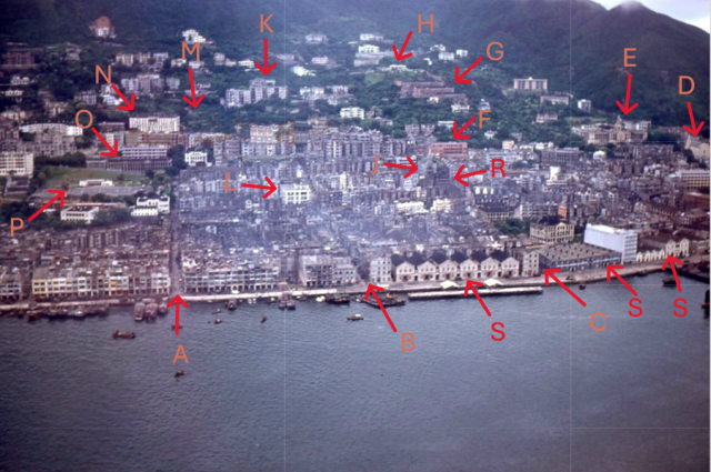
This is a photo taken from Gwulo’s node 20817. I decided to annotate the photo to point out some prominent landmarks in the Sai Ying Poon area back in the early fifties. The resolution of the photo is just average but is clear enough to identify some prominent buildings. Based on the history of when some prominent landmarks were built, this aerial photo is believed to have been taken between 1952 and 1953 for the following reasons: the new Tsan Yuk Hospital at the Hospital Road (just below King George the 5th memorial park in the photo) had not been built and the St Anthony church in the photo looks completed or almost completed.
Also, one can observe from the photo that starting from the Center Street waterfront going westward, the waterfront was lined with depots (the word “Godown” was used on some old HK maps) and reached all the way to Kennedy Town. These depots played an important role in making early Hong Kong an efficient trading port. After Hong Kong became a British colony, merchant ships from England brought in goods to Hong Kong. Instead of waiting for the ships from China to arrive in Hong Kong to pick up the goods directly from the British merchant ships, the goods would be unloaded and put in storage in these depots. The British merchant ships would then load up some goods that had arrived from China and stored in the depot earlier, and make a return trip to England with these goods from China. At a later date, ships from China would then come to Hong Kong and take the goods deposited in the depots from the earlier British merchant ships and bring them to different cities in China to complete the trade cycle.
A: Eastern Street
B Centre Street
C: Western Street
D: St Anthony Church
E: HKU Lok Yuk Hall (main Hall)
F: King’s College (High School)
G: HKU student residential Halls, Lugards, Elliot, and May halls
H : Resident of the HKU vice-chancellor (used to be Victoria Battery)
J: Kau Yan Church on Western Street
K: Mount Richmond
L: Sai Ying Poon Market
M: Upper section of the West End Park
N: St Stephen’s Girl's College
O: Government Mental hospital
P: King George the 5th Memorial Park
R: Old Tsan Yuk Hospital
S: Depots (or Godown as used in some old maps)