This photo is from the cover of the Dairy Farm 1967 annual report. This aerial photo was taken over the Waterfall Bay and covers the bulk of the Dairy Farm properties in the PokFuLam area. At that time, essentially all the lands in the PokFuLam area were owned by Dairy Farm and it looked very pristine with a lot of farmhouses and barns and dairy cows. I suspect that at that time, there were more dairy cows than humans living in that area. The pasture looks barren and brown in the photo, probably taken right after the harvest.
The upper road slopping down gradually from the left side of the photo to the right side is PokFuLam Road and the lower road hugging along the coast is Victoria Road. These two roads meet at the far right side of the photo. Around 1967, the HK Government Housing Authority had already started to develop the Wah Fu Estate with a lot of construction was already started when this photo was taken but was conveniently left out of this photo on the right side. Noted the two horizontal lines at a distance along the slope of Mount Kellett. They were dirt roads opened up by China Light so that they could have access to the hillside to build transmission towers. In the late sixties, China Light started to build a power station in Ape Le Chau, an island just across Aberdeen. To bring power to the north side of Hong Kong Island where the population is located, three transmission lines were also built during the construction of the power station. One of the transmission lines spans along the hillside of Mount Kellett, goes across the PokFuLam Reservoir, then hugs along the western slope of High West to bring power to the western district of Hong Kong.
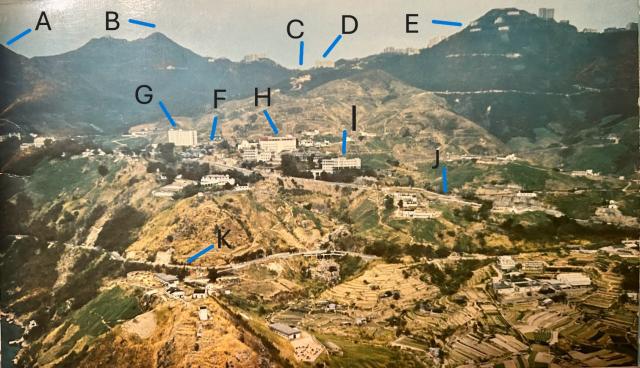
I put some markers on the photo so that the readers can have some ideas of the orientation.
A: Part of the High West
B: Victoria Peak
C: Victoria Gap
D: Peak Mansion
E: Mount Kellett
F: PokFuLam Village
G: 8-story high Dairy Farm staff residential quarters
H: Headquarters of Asian Food Industries (HK) Ltd (A subsidiary of the Dairy Farm)
I: Church Settlement according to the annual report but I believe it was a school (name forgotten)
J: PokFuLam Road
K: Victoria Road
A side note about this section of the PokFuLam Road that I would like to share with Gwulo readers. From an old HK map dated back to 1888, this section of the PokFuLam road from the PokFuLam Village to Aberdeen was called Aberdeen Road. The PokFuLam road at that time made a left turn at the PokFuLam Reservoir, went uphill, and reached Victoria Gap. Sometime later, it was decided to call the section of the PokFuLam Road from Victoria Gap to PokFuLam Reservoir, PokFuLam Reservoir Road and switch the section of the Aberdeen Road from PokFuLam Village to the Intersection of Victoria Road as part of the PokFuLam Road. The exact date of the switch is not known to me but is believed to be around 1900s. Also, this section of the PokFuLam Road went through a steep downhill and so the original road hugged along the contour of the hill and ended up very narrow and windy. In the 1964-65 time frame, this section of the road was straightened and widened the way we know today.
Comments
Correction
Instead of China Light, it should be Hong Kong Electric. China Light supplies power to Kowloon and New Territories. Hong Kong Electric supplies power to Hong Kong Island and Lamma Island.