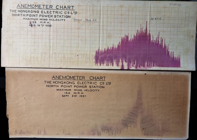
My father, Ian McKelvie, rescued these from North Point Power Station before he moved to the new Ap Lei Chau Power Station in the 1970s where he was the head engineer
It is a recent photo of the actual graphs, dated 16.8.1936 and 2.9.1937 (the last is faded or water damaged)
1936:
max wind speed 125 mph- per wikipedia gusts of up 131 mph:
death toll 20
https://en.wikipedia.org/wiki/1936_Pacific_typhoon_season
1937:
max wind speed 164mph (per wikipedia max unofficially 167 mph).
There is no official record as the anemometer could only record up to 125mph:
death toll 11-13,000, and one of the "deadliest typhoons in Hong Kong history"
https://en.wikipedia.org/wiki/1937_Hong_Kong_typhoon
Date picture taken
1930s
Shows event(s)

Comments
1937 Typhoon
Mention is made here of the anemometer at North Point Power Station regarding the 1937 Typhoon.
1937 Typhoon
Thks - the way my father told the story was the Observatory anemometer only recorded 125 mph as it was blown off. He was 7 at the time (my grandfather worked at Kowloon docks) so that would have been second-hand. Interesting that there is a difference from what is on the chart [164mph] and the one reported by Austin Coates [166.6mph] ("Mountain of Light" page 133) which seems oddly specific.
Anemometer Charts 1936 & 1937 North Point Power Station
The charts are 2 of 8 that I found in my father's study
1938 - The Observatory's New Anemometer
Following-up. Post typhoon, the Observatory's new anemometer can be read here in the Hong Kong Telegraph on 24 September 1938.