Whatever LandsD map used by centamap.com at present has this as Vista Cliff. Though on https://www.hkmaps.hk/viewer.html before applying an overlay it's shown as Vistacliff. In the 1982 aerial photo whatever was there before appears to be gone. The 1993 aerial photo shows what appears to perhaps be what was/is Vista Cliff/Vistacliff.
The current aerial photo on centamap.com looks to be a bit like what is in the 1993 aerial photo on hkmaps.hk.
Info about Wellness Lodge can be found in two places here: https://www.ntfcf.org.hk/our-initiase/ . One of the photos might make one wonder if it was the product of generative AI - with what might be an additional three floors on top of whatever may (if Sino Land is to believed) or may not be (if Google Maps is to be believed) there already.
Google Street View only appears to have a 2024-06 image that doesn't show the additional three floors above the rooftop garden depicted in the photo referred to in the previous paragraph. Can't really tell if what presumably was Vista Cliff/Vistacliff is the same as Wellness Lodge, but it doesn't quite look the same - so disregard the second paragraph above.
I'm left with the impression that "Wellness Lodge" gets its name due to the fact that everyone apparently wears face masks there.
Comments
wellness center
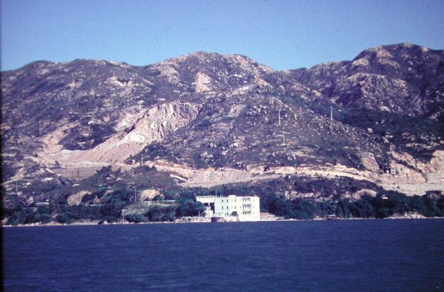
Is this where the "Wellness Center" on Castle Peak Road is now??
re: wellness center
Yes, I think that's the right location.
Looking at maps 1965.1 and 1970 at https://www.hkmaps.hk/viewer.html, it was called Riante Rive. I've made a Place for it at https://gwulo.com/node/60348
115 Castle Peak Rd Tsing Lung Tau now
Whatever LandsD map used by centamap.com at present has this as Vista Cliff. Though on https://www.hkmaps.hk/viewer.html before applying an overlay it's shown as Vistacliff. In the 1982 aerial photo whatever was there before appears to be gone. The 1993 aerial photo shows what appears to perhaps be what was/is Vista Cliff/Vistacliff.
The current aerial photo on centamap.com looks to be a bit like what is in the 1993 aerial photo on hkmaps.hk.
Info about Wellness Lodge can be found in two places here: https://www.ntfcf.org.hk/our-initiase/ . One of the photos might make one wonder if it was the product of generative AI - with what might be an additional three floors on top of whatever may (if Sino Land is to believed) or may not be (if Google Maps is to be believed) there already.
Google Street View only appears to have a 2024-06 image that doesn't show the additional three floors above the rooftop garden depicted in the photo referred to in the previous paragraph. Can't really tell if what presumably was Vista Cliff/Vistacliff is the same as Wellness Lodge, but it doesn't quite look the same - so disregard the second paragraph above.
I'm left with the impression that "Wellness Lodge" gets its name due to the fact that everyone apparently wears face masks there.
-kpl.