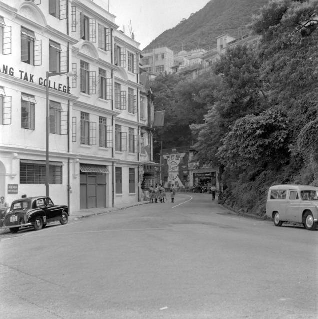
Looks like Robinson Road where the Chinese provision store used to be prior to the junction of Seymour Road. Cannot make out the name of the college though.
A higher resolution scan of the plaque by the entrance may help.
The Chinese name looks like X徳書院, the X has the shape of 和. If it is a 4-letter word _ANG in English, the only words that fit are probably DANG 但 and HANG 恒, HANG 恒 is the more likely choice.
Wang Tak College has been identified in the magnified photo. However, a google search of Wang Tak College has yielded no positive responses regarding its location.
That said, a search of the Chinese provision store "Charn Kee" on Robinson Road came up with a photo here on the public archive "Hong Kong Memory". "Charn Kee" (or its predecessor) and the building next to it on the right side of the road in the main photo were located on 49 Robinson Road.
The photo on Hong Kong Memory shows the window arrangement and the old and "new" road signs of Robinson Road on the building next to the grocery store which can also be seen in the main photo from 1956. These buildings have since been demolished.
Opposite "Charn Kee" was another grocery store called "So Kee". Perhaps the one seen in the main photo but on the left side of the road. Before supermarkets became popular, our family used to purchase daily necessities, bread, tinned food etc from "So Kee" on a signed chit basis. Outstanding bills were paid off on a monthly basis.
Located on I. L. No. 27, the buildings on the left side of the road had a street address of 54-62 Robinson Road. I think Wang Tak College may have occupied 60-62 Robinson Road.
In the "Hong Kong Memory" photo, the store was subdivided into 2 shops. The ~2 feet (stairwell) on the right was a shop called Four Kee 科記 that specialized in repairing miscellaneous items. It may also be true in the other photo as the rightmost 2 feet looked different.
At the magnified photo it is also found that there is name of another school on the building's wall, adjacent to Wang Tak College. The name in four Chinese characters is "仿林中學" (Fong Lam Middle School). Here is the photo with the four characters circled in red.
Name of Fong Lam Middle School circled in red, by Hoyin
From the Chinese Wikipedia, after the WWII Fong Lam Middle School was reopened with campus at No. 7 Seymour Road, and Nos. 58, 60 and 87 Robinson Road (Wikipedia: 仿林中學). The main photo shows the location at Nos. 58 and 60 Robinson Road, and the adjacent Wang Tak College is No. 62 Robinson Road.
Comments
Looks like Robinson Road
Looks like Robinson Road where the Chinese provision store used to be prior to the junction of Seymour Road. Cannot make out the name of the college though.
??ang Tak College
Looks like the partially visible letter might be an "A"? That might narrow down the possibilities a bit
College name
A higher resolution scan of the plaque by the entrance may help.
The Chinese name looks like X徳書院, the X has the shape of 和. If it is a 4-letter word _ANG in English, the only words that fit are probably DANG 但 and HANG 恒, HANG 恒 is the more likely choice.
Closeup of the plaque...
Unfortunately the image has novement blur so not able to get a clearer view
The blurred image is clear…
The blurred image is clear enough to see: 弘德書院 Wang Tak College
Re: Photo
Wang Tak College has been identified in the magnified photo. However, a google search of Wang Tak College has yielded no positive responses regarding its location.
That said, a search of the Chinese provision store "Charn Kee" on Robinson Road came up with a photo here on the public archive "Hong Kong Memory". "Charn Kee" (or its predecessor) and the building next to it on the right side of the road in the main photo were located on 49 Robinson Road.
The photo on Hong Kong Memory shows the window arrangement and the old and "new" road signs of Robinson Road on the building next to the grocery store which can also be seen in the main photo from 1956. These buildings have since been demolished.
Opposite "Charn Kee" was another grocery store called "So Kee". Perhaps the one seen in the main photo but on the left side of the road. Before supermarkets became popular, our family used to purchase daily necessities, bread, tinned food etc from "So Kee" on a signed chit basis. Outstanding bills were paid off on a monthly basis.
Located on I. L. No. 27, the buildings on the left side of the road had a street address of 54-62 Robinson Road. I think Wang Tak College may have occupied 60-62 Robinson Road.
In the photo, the store on…
In the photo, the store at the corner on the G/F of the college with three five-star flags flying above it was named 何生記 Ho Sang Kee Store.
Re: Ho Sang Kee Store
I was struggling to find its name. Thanks.
Wang Tak College address
I found a 1963 book on Google Books that gives the address of Wang Tak College as 62 Robinson Road: https://books.google.com.hk/books?id=AJNGAAAAMAAJ&pg=PP14&dq=%22WANG+TA…
I've made a Place for it at https://gwulo.com/node/60085
That's a very impressive bit…
That's a very impressive bit of sleuthing by everyone, well done. Another reason why Gwulo is a great resource.
Four Kee 科記
In the "Hong Kong Memory" photo, the store was subdivided into 2 shops. The ~2 feet (stairwell) on the right was a shop called Four Kee 科記 that specialized in repairing miscellaneous items. It may also be true in the other photo as the rightmost 2 feet looked different.
At the magnified photo it is…
At the magnified photo it is also found that there is name of another school on the building's wall, adjacent to Wang Tak College. The name in four Chinese characters is "仿林中學" (Fong Lam Middle School). Here is the photo with the four characters circled in red.
From the Chinese Wikipedia, after the WWII Fong Lam Middle School was reopened with campus at No. 7 Seymour Road, and Nos. 58, 60 and 87 Robinson Road (Wikipedia: 仿林中學). The main photo shows the location at Nos. 58 and 60 Robinson Road, and the adjacent Wang Tak College is No. 62 Robinson Road.
仿林中學 (Fong Lam Middle School)
Hoyin,
Good catch.
As 仿林中學 (Fong Lam Middle School) was a pro-ROC school, the corner building flying 5-star flags was unlikely part of its campus.