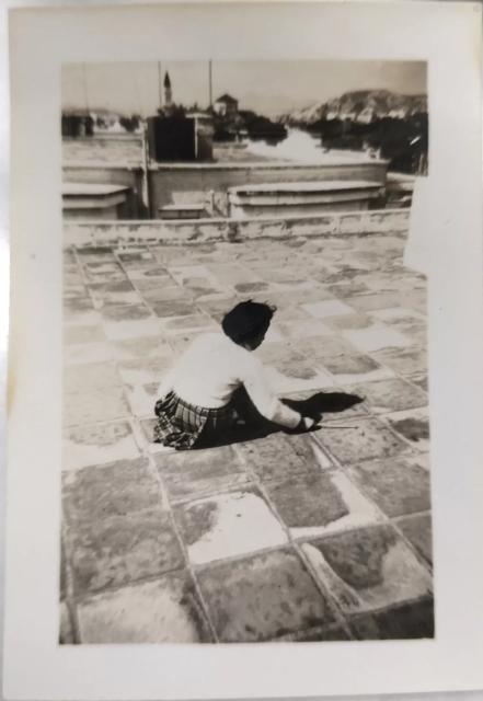
I agree with moddsey. That's St Teresa's in the background and the photograph would have been taken on the roof top of a low-rise residential block situated on the north-side of Prince Edward Road , probably somewhere between about street numbers 290 & 300.. During the late 1960's there was coffee lounge/bar on the upper foor in one these nearby blocks although it did not survive for long. There was another nearby coffee shop/restaurant with a small bar ( named the 'Captain's Table') on the south-side of Prince Edward Rd ( diagonally opposite to St Theresa's Church which fared better and survived for almost a decade. It was the favourite late-night drinking hole of a senior police officer named Brian Slevin who later became Commissioner of Police.
Looking at the photo again. Is that Kadoorie Hill and Waterloo (Ho Man Tin) Hill on the right ? Not sure if one is looking at the Church from a northerly direction as the tall tower and the fatter rounded-tower of St. Teresa's appears on the left and right respectively ?
I should have clarified that the camera (on north side of Prince Edward Road) would have been facing westwards towards Mong Kok. From this position the tall tower of St. Teresa's would then be on the left as it in this photo.
I suggest the rocky outcrop seen to the left is perhaps near where La Salle Road meets the junction of Nga Tsin Wai Rd, the latter being named Lancashire Road west of this junction. Much of the summit of this hill was flattened as the La Salle Road district of Kowloon Tong was developed from the 1980’s. There is still a small residual section of this outcrop’s summit at the corner of Nga Tsin Wai Road and La Salle Road. At this location there are two or three low-rise residential blocks with ground floors considerably higher than adjacent blocks and there is a high concrete retaining wall to stabilize this remaining high point .
If , on the other hand, observers think this hill is too distant to be near La Salle Road then perhaps this is Beacion Hill ? ....and yet another possibility, could it be Woh Chai Hill near Shek Kipo Mei ?
St. Teresa's seems very close to the house where the photographer was located. After looking up Google Map, I suspect the house was somewhere between Boundary Street and Prince Edward Road. I could not say exact where, but likely around present day Earl Street.
I think this is the south side of Prince Edward Road, looking west. The positionof the house relative to the church makesit lookas though they are onopposite sides of the road, plus the dark area (below the hill- yes, Wo Chai/Bishop's Hill in Shek Kip Mei) on the right side of the image looks to me like the old pitched roofing of the mansions that used to line to north side of the road.
If you look at the 1949 aerial images on HKmaps, you can see the difference between the north and south sides of the road at that time - pitched roofing on the north, flat roofing on the south,immediately east of the church.
There's a row of large houses that appear to have curved window tops, like the ones on the image, that were located between today's Tai Gardens and Erin Court (#285 -297) - it could be one of these properties.
Comments
St. Teresa's Church
I think that is the tower of St. Teresa's Church in the background.
Prince Edward Road East - Rooftop Photo
I agree with moddsey. That's St Teresa's in the background and the photograph would have been taken on the roof top of a low-rise residential block situated on the north-side of Prince Edward Road , probably somewhere between about street numbers 290 & 300.. During the late 1960's there was coffee lounge/bar on the upper foor in one these nearby blocks although it did not survive for long. There was another nearby coffee shop/restaurant with a small bar ( named the 'Captain's Table') on the south-side of Prince Edward Rd ( diagonally opposite to St Theresa's Church which fared better and survived for almost a decade. It was the favourite late-night drinking hole of a senior police officer named Brian Slevin who later became Commissioner of Police.
Re: Rooftop View
Looking at the photo again. Is that Kadoorie Hill and Waterloo (Ho Man Tin) Hill on the right ? Not sure if one is looking at the Church from a northerly direction as the tall tower and the fatter rounded-tower of St. Teresa's appears on the left and right respectively ?
Rooftop View
I should have clarified that the camera (on north side of Prince Edward Road) would have been facing westwards towards Mong Kok. From this position the tall tower of St. Teresa's would then be on the left as it in this photo.
I suggest the rocky outcrop seen to the left is perhaps near where La Salle Road meets the junction of Nga Tsin Wai Rd, the latter being named Lancashire Road west of this junction. Much of the summit of this hill was flattened as the La Salle Road district of Kowloon Tong was developed from the 1980’s. There is still a small residual section of this outcrop’s summit at the corner of Nga Tsin Wai Road and La Salle Road. At this location there are two or three low-rise residential blocks with ground floors considerably higher than adjacent blocks and there is a high concrete retaining wall to stabilize this remaining high point .
If , on the other hand, observers think this hill is too distant to be near La Salle Road then perhaps this is Beacion Hill ? ....and yet another possibility, could it be Woh Chai Hill near Shek Kipo Mei ?
Re: location of photographer
Hi there,
St. Teresa's seems very close to the house where the photographer was located. After looking up Google Map, I suspect the house was somewhere between Boundary Street and Prince Edward Road. I could not say exact where, but likely around present day Earl Street.
T
Re: Location of Photographer.
Looked at Google Earth. Yes, looking west towards Mong Kok. Thanks.
south side
I think this is the south side of Prince Edward Road, looking west. The positionof the house relative to the church makesit lookas though they are onopposite sides of the road, plus the dark area (below the hill- yes, Wo Chai/Bishop's Hill in Shek Kip Mei) on the right side of the image looks to me like the old pitched roofing of the mansions that used to line to north side of the road.
If you look at the 1949 aerial images on HKmaps, you can see the difference between the north and south sides of the road at that time - pitched roofing on the north, flat roofing on the south,immediately east of the church.
There's a row of large houses that appear to have curved window tops, like the ones on the image, that were located between today's Tai Gardens and Erin Court (#285 -297) - it could be one of these properties.
1935 Prince Edward Road
Rooftop aerials on the south side of Prince Edward Road.