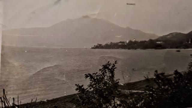
It's Castle Peak, but the location of the photographer is a bit difficult to pinpoint. There's no sign of Pearl Island on the left so perhaps somewhere around So Kwun Tan area (i.e. current Gold Coast area) ?
Maybe further east. The peninsular looked like Lok On Pai area. There are some buildings along the ridge so maybe we could have some photo matching to play with?
Maybe the photographer was somewhere in Tai Lam Chung area, close to the coast.
T
ps More investigation required. Just fired up Google Earth and drawn a line between the Peak (Castle Peak) and the tip of Lok On Pai. The line did not extend to Tai Lam Chung at all. Instead it should be out in the sea a bit at Tai Lan Chung area. If further extend the line, the land it could reach would be North Lantau, close to Tsing Chau Wan.
See if this works. The fairly straight shoreline (edit: I meant to say how its orientation relates to the peak of the hill as it appears in the photo) could be a clue. In the 1952 contour map, I think the photographer was at the top end of that short stretch of road running north-south next to Brothers Point. The view to Pearl Island was blocked by the land to the west. Regards, Peter
Looking at Castle Peak from Cafeteria Beach below. The main photo appears to be taken further east, perhaps from Golden Beach. Not sure how far east the beach went in the 60s.
That said, on the 1960 Hong Kong Map at https://www.hkmaps.hk/viewer.html opposite So Kwun Tan, there are 2 Holiday Villas and a Swiss Cottage.
This could be a potential site. On one of the other holiday villa images I mentioned that the background looked a bit like Brick Hill from above Deepwater Way, but looking at this new information it could very well have been the southern slope of Castle Peak- the topography of the two is similar from a distance. 3D googleearth provides a similar angle on Castle Peak from that area.
The current site there has an older structure marked as "Ngan Tsui House" and I think this was one of the 3 structures there in the early 60s.
Edit: there is some similarity between Ngan Tsui House and the image of the villa roof,see here - https://gwulo.com/media/43623
Comments
Castle Peak
It's Castle Peak, but the location of the photographer is a bit difficult to pinpoint. There's no sign of Pearl Island on the left so perhaps somewhere around So Kwun Tan area (i.e. current Gold Coast area) ?
Re: Castle Peak
Hi Phil,
Maybe further east. The peninsular looked like Lok On Pai area. There are some buildings along the ridge so maybe we could have some photo matching to play with?
Maybe the photographer was somewhere in Tai Lam Chung area, close to the coast.
T
ps More investigation required. Just fired up Google Earth and drawn a line between the Peak (Castle Peak) and the tip of Lok On Pai. The line did not extend to Tai Lam Chung at all. Instead it should be out in the sea a bit at Tai Lan Chung area. If further extend the line, the land it could reach would be North Lantau, close to Tsing Chau Wan.
Castle Peak
Hi Phil and Tngan, I think you both got it.
See if this works. The fairly straight shoreline (edit: I meant to say how its orientation relates to the peak of the hill as it appears in the photo) could be a clue. In the 1952 contour map, I think the photographer was at the top end of that short stretch of road running north-south next to Brothers Point. The view to Pearl Island was blocked by the land to the west. Regards, Peter
View of Castle Peak
Looking at Castle Peak from Cafeteria Beach below. The main photo appears to be taken further east, perhaps from Golden Beach. Not sure how far east the beach went in the 60s.
That said, on the 1960 Hong Kong Map at https://www.hkmaps.hk/viewer.html opposite So Kwun Tan, there are 2 Holiday Villas and a Swiss Cottage.
Holiday Villas @ So Kwun Tan
This could be a potential site. On one of the other holiday villa images I mentioned that the background looked a bit like Brick Hill from above Deepwater Way, but looking at this new information it could very well have been the southern slope of Castle Peak- the topography of the two is similar from a distance. 3D googleearth provides a similar angle on Castle Peak from that area.
The current site there has an older structure marked as "Ngan Tsui House" and I think this was one of the 3 structures there in the early 60s.
Edit: there is some similarity between Ngan Tsui House and the image of the villa roof,see here - https://gwulo.com/media/43623
So Kwan Wat Bay
Lightened the image so we can see what we are looking at.
Vegetable gardens are below Castle Peak road level.
Which is where the photographer is standing.
Thank you
Wow, thank you so much for the information. Really interesting and its great to know where i was xx