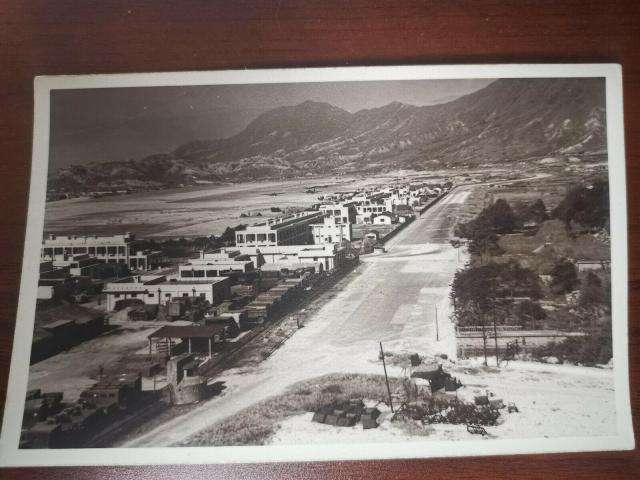
The concrete buildings were still there in 1957 when I attended Good Hope School, so were the circular island and the shed selling farm equipments. On the right was the start of Clear Water Bay Road going uphill. The army trucks were no longer there replaced by Nissen huts. Regards, Peter
Thank you Daniel for the reply. I need to clarify my previous message. The start of Clear Water Bay Road is in the top right of your photo, about where the white rectangular patch of roadway is. The road on the lower right of the photo including the farm equipment shop is today's Choi Shek Lane - see red dot in the photo below. So, in fact, there were two shops. I think there was only one owner who started at the southern site, and later moved (when the city widened the road) to Clear Water Bay Road seen from my school bus.
You too have a nice weekend. It is -22 degrees C here tonight at my place, outside!
Comments
Kai Tak RAF Base
early postwar-mid 1940s
Kai Tak Airport
Hi Daniel,
Your photo appears in the collections at - https://images.hollis.harvard.edu/primo-explore/search?query=creator,co…; (Page 7), Creation Date 1946-47.
The concrete buildings were still there in 1957 when I attended Good Hope School, so were the circular island and the shed selling farm equipments. On the right was the start of Clear Water Bay Road going uphill. The army trucks were no longer there replaced by Nissen huts. Regards, Peter
Kai Tak Airport
Thank you veru much Peter for the information. Have a great weekend and best regards, Daniel
1947 View of eastern part of Kai Tak Airport
Thank you Daniel for the reply. I need to clarify my previous message. The start of Clear Water Bay Road is in the top right of your photo, about where the white rectangular patch of roadway is. The road on the lower right of the photo including the farm equipment shop is today's Choi Shek Lane - see red dot in the photo below. So, in fact, there were two shops. I think there was only one owner who started at the southern site, and later moved (when the city widened the road) to Clear Water Bay Road seen from my school bus.
You too have a nice weekend. It is -22 degrees C here tonight at my place, outside!
View of Eastern Part of Kai Tak Airport
Thank you so much Peter for your information. It's very helpful indeed.
Best regards and a happy Chinese New Year to you and your family
Daniel