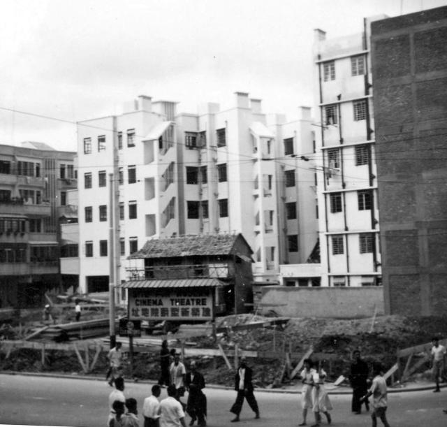
Judging by the buildings in the background, I think that a photograph of this place, the Wan Chai market (?) has appeared previously, although the presence of an outdoor (?) cinema on the site is a puzzle. (Andrew S)
Thank you Raymond for identifyng where the New York Theatre was to be built. Andrew
Date picture taken
1950s
Gallery
Shows place(s)
Comments
The site of the New York
The site of the New York Theatre.
The site of the Cathay Theatre(國泰戲院)
Judging from the street on the site's right side, it is highly likely that it is the Cathay Theatre. The main road shown should be the Wanchai Street. It also matches the specified location of the photo. The New York cinema was located in Hennessy Road, more in the Causeway bay area. Also, the cinema was built alongside with other low rise buildings back in the 1970s if I recall. A side road on its right could not possibly fit in. A double check on old time map may confirm.A photo of the Cathay Theatre has been uploaded to Gwulo tagged "the Cathay Theatre for comparison.Re: Cinema
My observation of the scene when it was first posted was that the photo appears to have been taken from a passing tram.
The poles with overhead electrical wires suggest these were tram poles and connected wiring.
I think above the building on the extreme left rises Victoria Peak. Indications are it is the New York Theatre.Re: Those houses with chimneys
Hi There,
If it had been the New York Theatre site, those buildings with chimneys may not match. There are still a row of those in Lockhard Road in CWB, but they are only four storeys tall.
T
ps My bad. I went to Lockhard Road earlier and found the row of older houses are in fact five (5) storeys tall. So it is likely to match. Once again, proved Google street view is not always reliable owing to the limitation on how the images are viewed.
Cathay
According to this page: https://gwulo.com/cathay-theatre, the Cathay was constructed in 1939, so I'm not sure how it could appear as a building site in the 1950s. But also, as T mentions, the background doesn't match the New York site either...
Re: Along tram line
Hi There,The alignment of the site could be the former Olympia Theatre. But that wasn't opened until the mid 1960s. May be we need some old photos of Power Street and Electric Road just to see if there is a match of those buildings in the background. But chances is slim. The timing was not right.The row of balcony houses, if correct, become the Luen Wo Apartments, which started occupation in 1962.Tps. HKMS 2.0 has a series of 1963 aerial photos covering the area. The Olympia wasn't there yet. But the Mapping had taken away the ability for us to zoom in on the photos online.Re: Ruling out Causway Bay & Wanchai
Hi There,I believe we can rule out both Causeway Bay and Wanchai as those post WWII older houses in these areas were mostly four storeys tall, as seen in many old photos from 1950's through 1970's. I am not old enough to remember those of Electric Road. I wasn't even there yet in the 1950s.On there other hand, there is still a row of similar houses in Jupitar Street nearby. They are also four storeys tall though.TCapitol Theatre - near Hennessy Rd/Jardine's Bazaar?
Hi tngan,I found a photo of the Capitol Theatre site after its demolition and uploaded it under "place" Capitol Theatre (https://gwulo.com/media/53425). It resembles the background of the old picture before construction. However, those town houses do not have chimneys..not sure if they had been removed /decommissioned. Your inputs will be very much appreciated.If taken on a tram near Hennessy Road / Jardine Bazaar junction, similar tram cables could have been picked up in a photo. In fact, several photos of the Theatre taken at similar angle in gwulo also picked up the tram cables (https://gwulo.com/media/23353).The Theatre started operation in 1952 thus timing seems to match.Note from the other photos that the current triangular pedestrian island was not there where the two roads met. That could be the reason why the roads seem a bit wide. With this orientation, the front should be the Jardine's Bazaar, and the right side road should be the Jardine's Cres.I'm afraid that I cannot…
I'm afraid that I cannot really add any positive comment about the exact location of this photograph, except to suggest that most of the guys at Little Sai Wan who went 'down town' would get a lift on one of the RAF gharries (3 ton Bedford trucks) on its way up to the Battys outstation on the Peak. We would almost always be dropped off at either the Windsor cafe in North Point or at the west end of Causeway Bay, and we would then walk through Wan Chai along either the Hennessey or Jaffa Roads. Many of my and other photographs were taken of the iconic shop house blocks in Wan Chai.
1954 Wanchai, Causeway Bay and Victoria Park Reclamation
Attempting to show the white coloured buildings in the main photo which I think are on Lockhart Road, particularly the irregularly-shaped building with the descending staircase on the left.
Not a clear photo below, given the photographic limitations. Three specks of fading sunlight appear to fall on these buildings. New York Theatre has not been constructed yet.
buildings
Moddsey, do you mean the ones that surround the north and north east side of the plot? If so I think the peak is more likely to be on Kowloon side rather than be Victoria Peak, but it certainly matches a bit better if the original photo is looking NE/NNE
Re: Buildings
Got my orientation of the plot wrong with the comment about Victoria Peak. I have deleted it.
I recently had a look at photos from 1953/54, mostly overhead views like this one below:
At this stage, I also have my doubts about the site being the New York Theatre. But I still think the photo was taken along the tramline.
Lockhart Road Buildings
Looking at the main photo and the darker buildings on the left, are they a match for the same buildings below that has been recently posted? They appear to have the same curvature.
New York Theatre Site - Final
Thank you Moddsey for the aerial photo.
I managed to identify the 5-storied Hennessy Hotel located at the southwesten corner of the hennessy Road/Percival street junction https://gwulo.com/media/53480 and https://gwulo.com/media/36381 . From there we can see a vacant site adjacent to a row of town houses at the northeaster corner of the same junction, where the NY theater was later built. Your photo also shows townhouses along Lockhart Road, behind the site.
On re-examining the subject photo, I believe the photo was taken near the Hennessy Rd/Percival St, looking at a northeastern direction, showing lowrise houses along lockhart road on the left and "end wall" of lowrise houses along Hennessy Road on the right.
I found a new photo (taken in 1960s) which shows this Lockhart Road junction and the lowrises matches the subject photo nicely. https://gwulo.com/media/53479 .
This 1958 photo of the Threater https://gwulo.com/media/53482 also shows it was built adjacent to the end of a row of lowrises.
I hope this concludes my early doubts on the location. I am now 100% behind the original heading.
Lockhart Road buildings
Yes. Not just the curvature but also the physical appearance of the buildings as shown in this picture just uploaded. Note also the match of the building on the right side of this photo vs the original photo. The balcony was enclosed in this photo.