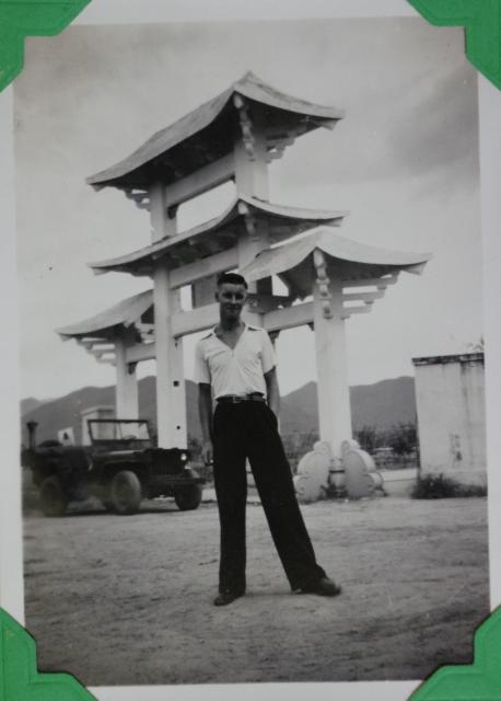
Does anyone recognize the arch below from any other photos or anything you've seen anywhere?
The photo is taken of my grandfather, who did his (British) national service in Hong Kong between 1948 and 1949. He remembered the arch (and a house) from Fanling shortly after a storm on the 9th of September 1949. (Googling these dates indicates it may have been "Hurricane Nelly") which hit Hong Kong around that time.
I went to Fanling with my wife and we tried asking some random old people, but none of them recognized the archway in the photo :-)
Date picture taken
9 Sep 1949
Gallery
Comments
This is my first post in
This is my first post in Gwulo. I found this photo when I was searching for something about "Fanling", my hometown. Out of curiosity, I also want to know the exact location of this archway taken in Fanling more than 70 years ago. I posted the link of this photo on a Facebook group and asked Fanling neighborhoods for help.
A group member recognized the mountains in the background: Bird's Hill (龍山)and Cloudy Hill (九龍坑山). Perhaps this photo was taken near Fanling Train Station. Besides, one group member asked her great-grandma about the archway! Her great grandma identified it as an archway in Fung Ying Seen Koon, a Taoist shrine founded in 1929. She said the archway had been demolished because of an unknown accident.
Unfortunately, I didn't find any verifiable evidence confirming the oral history so far. One of the possible ways is to access the archive of Fung Ying Seen Koon and verify the existence of the archway.
Fanling
Hi Carbonmeteor, welcome to the site.I think your friend is correct about the background hills, so I think your guess at the location might be correct.
I did visit Fung Ying Seen Koon several years ago (circa 2013 perhaps earlier) and talked to some local hikers who told me the place suffered a catastrophic fire sometime (I can't remember when) and had to be rebuilt. There are a couple of original structures there but for the most part the current temple complex is relatively new.
Phil
Edit: Looking at aerial images from the 1960's it's possible to see a large open sandy area to the NE of the current site which would tally with the image. Unfortunately, earlier aerial images (from 40's and 50s) are too few and too high to be useful. It looks as though this empty site may have been an access point to Fung Ying Seen Koon for vehicles, so it's possible this is where the arch was located. If so, then it looks to have gone by the 60s. Anyway, the angle of the access road and the view to the hills in the background seem to tally.
I also notice it was given the label "The NAAFI gate" on this picture of the album: https://gwulo.com/media/38784
so perhaps if someone can remember where the NAAFI was in Fanling it might help.