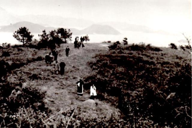
This is a picture of the site where the plaque that commemorates my grandmother Annie Louisa Olson's gift of land to the home was placed. It is up near trees at top of rise.
Sure was a good view. No wonder it sold later.
Date was July, 1969. Apologise for quality. Must have been a duff box brownie that took the pic. Came across it when looking out some pics regarding an earlier post about the home.
Any info or history about the plaque appreciated. No info from present St Christophers.
Sean
Date picture taken
28 Jul 1969
Gallery
Comments
background to the photo
Sean
I think you are right and this is taken in the general area. If you look in the harbour at the very right hand side you can see one end of Centre Island. Ma Shi Chau (the pointy bit centre shot) can be seen in the harbour in the centre of the picture and it is, of course, joined to the mainland by the Sam Mun Tsai peninsula.
Question is, was this photo taken from the Olson plot, or was it taken of the Olson plot? If the former, then the information supplied to you by the church previously would tally - however, if it is a shot of the plot then there is no way the plot they indicated in their email to you could be the right one.
Just some personal thoughts.
Phil
re:background to photo
Hi Phil,
Now I am really confused.
This picture comes from an album of pictures taken on the day of the presentation and I assume that it is of the then Bishop and his acolytes descending from the place where the plaque to my grandmother was placed.
Having no idea of the area I am not in any position to make a judgment.
Perhaps David may be able to shed some light. If I can find the picture of the bishop and co at the plaque by the tree it might be of help.
Also which Church are we talking about? Old memory failing!
Sean
SeanThis is definitely the
Sean
This is definitely the area around where Deerhill Bay now stands. The angle on the various background terrain fits.
My point refers back to a plot map and information you were sent last year (by the St Christophers Home - sorry to confuse you I thought they were part of the Church) which you kindly shared with me. The info gave you an exact area showing the 'supposed' Olson plot - Lot T77.
The plot on that map is a small patch of land that remains undeveloped (but shot-creted) that sits right next to the current Japanese International School, Po Leung Kuk School and the entrance to Deerhill Bay. It's right next to Tai Po Road.
The info from that email mentioned that the Govt decided to remove the hairpin bend on Tai Po Rd and have it straightened and as such it cut through the Olson land (so they Govt had to retake the Olson plot in some sort of land swap deal).
Looking at the above photo - and assuming IT IS a picture of people walking back from the Olson plot - I just can't reconcile this photo and my knowledge of the terrain there with the map and info you were sent last year. I suspect that the information you were given by St Christophers Home is duff and that the land was much further to the east, closer to the coastline and where the Deerhill development currently stands (i.e. not next to the current route of Tai Po Road)
Cheers, Phil
Thanks Phil
Think I owe you a beer.
Ken's seeming failure to recognise the pics I sent him sort of threw me and not having any knowledge of the area - and having so many skeletons in the family cupboard - I began to wonder if something was up.
As you may know when I opened the Pandora's box that contains my HK roots all fans speeded up as things flew everywhere. This, I am sure, is a false alarm.
Thanks for the clarification.
Sean
Streetview
Sean - now that I have seen this photo, I can play with the angles myself a bit and perhaps head up there to see if I can find a similar angle - however, to get that far away from the Olson plot I would have to climb up the hillside on the opposite side of the road - hence why I am currently wondering if plot T77 is the Olson plot after all. Anyway, you can have a look around here thanks to Google Streetview:
http://maps.google.com.hk/maps?hl=en&ll=22.429907,114.195945&spn=0.0022…
Streetvew
Thanks for the Google view. Guess grandma's plaque is long gone.
Wish we'd kept the land. Could have had a good party selling it today.
Any idea why today's St Christopher's outfit does not seem too keen of giving out info?
Sean
Sean - who knows? It could
Sean - who knows?
It could just be that the area has changed so much that the T77 plot is the Olson land - however, I'm not yet convinced. It strikes me as very convenient that the Olson plot just happened to be the only parcel of land that wasn't included in the Deerhill Bay sale and was taken over by the Govt so they could reroute Tai Po Rd.
It could just be they don't actually know but felt the need to give you info regardless of its accuracy. This way they can fob you off, save some face and lay blame for the loss of the plaque firmly in the hands of the Govt.
Perhaps they fear there were conditions on the donation that may have been breached when they sold to Li Ka Shing? Don't forget they were investigated for tax on this deal only a few years ago (though I can't remember the outcome).
Maybe they think you are trying to garner information to so you can claim back the land? :-)
Sometimes people just find it hard to believe that you seek information simply because you have an interest in the past. They assume that you have ulterior motives which probably involve some sort of money angle.
Anyway, don't lose heart yet. I'll will try and get up there soon and see if I can get a clear view into the harbour to make some comparisons.
pictures of tolo harbour should match your photo
Hi Sean, i was trolling again, and found a website "samsays" and this update photo seems very close, look just south of your photo. good luck, ken