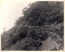
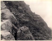
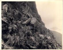
Barbara Park has kindly shared these photos of Lugard Road under construction. Running along the north face of the side of the Peak, it's got some of the best views of the city and the harbour.
I thought it would be easy to pin down a date for these photos, but it turns out the road was built in two sections, with a five-year gap between them. More on that later, let's start with the photos:


When & where were they taken? Back to the story of the road's construction...
The first reference I found was from 1913, when the government's Public Works Department requested sealed tenders for building a section of "the Road from Victoria Gap to High West Gap." [1]
Arguments in favour of road-building usually concentrated on the new land that would become available for building on, and the profits the government would make from selling that land. But in this case, "Though a few building sites will be rendered available on a spur below the signalling flagstaff, the road will be principally used as a promenade, a wonderful panoramic view of the City, Harbour and surroundings being obtainable from it." [2]
This first section was 2,820 feet long. It started at Victoria Gap (near the Peak Tram station) ran along the hillside below Mount Austin Barracks, and finished some way past the Bishop's Lodge. Work started in June 1913, and was soon finished: by the end of the year all that was left was to surface the road and put up the railings. [2]
After that things slowed down.
The remainder of the road was much more difficult to build, "as its execution is attended with considerable difficulty on account of the rocky and precipitous nature of the hillside to be traversed." [3] Still, in 1914 Legco approved $10,000 to pay for a further extension of the road. They also decided "to call this road Lugard Road after the late Governor." [4] ('late' meaning he wasn't the Governor of Hong Kong any more, not that he'd died!)
But the money wasn't spent, as next year's PWD report says "it was decided not to proceed with the work". [5] No doubt World War 1 meant that many non-essential projects were put on hold.
In January 1919, with the war over, work began again. [6] This second section would be 4,850 feet long, and take the road right around to High West Gap, where it would join up with Harlech Road. [7] As expected, it was much more difficult to build, and wasn't completed until March 1921. [8]
Looking back at those pictures, they were taken along a section with a very steep slope. I guess they show work starting on the second section, early in 1919.
Barbara also sent a couple of later photos. This one should be in early 1921, as the railings were one of the finishing touches to the project.

And one a little while later, showing the end result:

Thanks to Barbara for letting us see these photos.
Regards, David
PS The view of the Peak from the harbour is a popular subject for postcards, and Lugard Road is clear to see. Does anyone have one taken between 1914-1918, showing just the first section of Lugard Road completed?
References:
- No. S. 143.
- Point 107.c in the PWD's Annual Report for 1913.
- Legco minutes for 9th October, 1913.
- Legco minutes for 22nd October, 1914.
- Point 105 in the PWD's Annual Report for 1915.
- Point 98.g in the PWD's Annual Report for 1919.
- Point 100.c in the PWD's Annual Report for 1920.
- Point 101 in the PWD's Annual Report for 1921.
Photos that show this Place