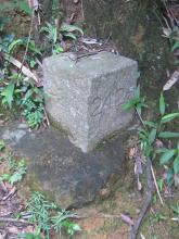
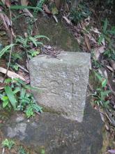
Current condition
Ruin
I saw this one yesterday, but have no idea what it's for.

If you walk down Aberdeen Reservoir Road from Wan Chai Gap, it's up on the right, just where the Hong Kong Trail branches off from the road.
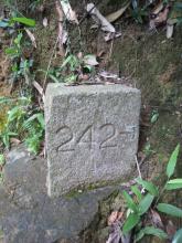
The left side of the stone has the text '<- 24' engraved, pointing along the Hong Kong trail. The other side has the text '242 ->', pointing along a muddy looking trail that leads off to the right. There are traces of red paint in the engravings.
Can anyone explain what it was for?
Photos that show this Place
2009
2009
2009
Comments
Marker Stones around the Aberdeen Reservoir Country Park
Hi there,
I have seen two similar stone where the catch water meets the service road in the Lower Reservoir neighbourhood. Here it is, the 26 Stone:
he 27 stone is near the main dam of the Upper Aberdeen Reservoir:
Best Regards,
T
re: Marker Stones around the Aberdeen Reservoir Country Park
T,
Thanks for the extra photos.
Maybe they marked out the old catchment area around the reservoir? Though they don't match today's 'country park boundary', which I always thought was the boundary of the catchment area.
I'll keep an eye out for more around this area, or around other reservoirs.
Regards, David
Re: Marker Stones around the Aberdeen Reservoir Country Park
Hi there,
We need sharp eyes, i guess. I began to wonder where would be the 25 stone marker. It should be somewhere between the 24 & 26 stones, right? I'll try to poke around the area where the catchwater joins the Upper Reservoir (around the bunkers) next time walking by.
Best Regards,
T
Re: Marker Stones around the Aberdeen Reservoir Country Park
If we get a few more, I'll plot them on a map, and maybe that will give some more hints to their purpose.
Re: 26 & 27 stone markers
Hi there,
I have already marked the pproximate locations of the 26 & 27 stones using the tags aberdeen, aberdeen reservoir, marker stone.
Best Regards,
T
Map of marker stones around Aberdeen Reservoir
Excellent! I've just added tags 'aberdeen reservoir' and 'marker stone' to this place, and here's the map of places with those tags:
<?php //$view_args = array('370,671'); //Term IDs for 'aberdeen reservoir' and 'marker stone' //$view_name = 'places_map_arg'; //name of view //$view = views_get_view($view_name); //if (!empty($view)) { // echo $view->execute_display('page_1', $view_args); //} echo views_embed_view('places_map_arg', 'page_1', '370,671'); ?>
re: 26 & 27 markers
Rob notes that one side of the '26' stone is actually marked '261', which I hadn't noticed. He also points out the 27 stone's arrow points directly at the pillbox - a coincidence? Or a sign that they had a military purpose?
A quick comparison of the engravings:
Does that give anyone any new ideas about their purpose?
Re: 26 & 27 stone markers
Hi there,
Interesting. I had even tried to browse places using only the tag Aberdeen Reservoir. That showed all bunkers and pillboxes around the area known by us but still, I have been scratching head since.
We need some more field trips, I guess.
Best Regards,
T
I might have found the 25 marker, but.....
Hi there,
I went to the Reservoirs again earlier and I might have found the 25 marker. However the engraving was sort of difficult to confirm as the stone appeared to be on its side and the engraving is oon the original skyward face.
The stone was actually right next to the bunker I discovered back then, at the locatin where the catch water goes into the Upper Reservoir.
Can you see it? Probably not. Just zoom it in at Google Maps. The shape and size are right, it's just that on it's side.
Let's imagine the engraving is facing skywards. One of the arrows points towards the wall of the bunker next to it while the other arrow points towards the road, where there is a cluster of bunker nearby. I have to admit the engraving looked a bit like 26 too, but would it make sense t have two 26 markers?
Best Regards,
T
I think I might have also found a War Department Marker Stone
Hi there,
I spotted a stone marker with a pyramid top with a WD engraving on the side facing the road. However other marks are not clear. We might need a rubbing to get a better picture.
It is right besides a maintenance steps. Let get closer:
Best Regards,
T
Stones around Aberdeen Reservoir
T,
Good work finding those. I feel like I was cheating with the stones around Kennedy Road, as I had a map to follow!
I'm pretty sure the latest stone you mention is a War Department stone. It has the /|\ on top, then the W D below, and the number is probably buried under the cement. I'm not sure what the military lot was in this area, but it does add weight to the argument that these other stones had some military significance.
Then for the previous stone, it does look like 26, doesn't it? So, rather than the WD lot markers, which had increasing numbers, these must work in a different way. It seems to say that 26, whatever that is, is ahead and to the right.
You also mentioned that the stone may be on its side. Were you able to see the top of the stone? It's not clear to see in the photo. If the top is square, I think the stone is standing upright in its original format. If the top is a rectangle, that would suggest it is lying down on one side.
I'm still no wiser what they are though :-(
David
25 Marker, or whataever it is
Hi there,
The current skyward surface is a ractangle The closer photo didn't show the whole stone very clearly as there are weeds around it. I have to pull a bunch of the weeds off the sides before I could have a closere look of it's former top. I guess I will start looking for these type of stones on Hong Kong Island, especially in places known to have WWII ruins.
Best Regards,
Thomas
Re: Stones around Aberdeen Reservoirs
Hi there,
The War Department Stone was unexpected, but I should have spotted it before as I am a frequent (frequent being quite a few tmes a month) wanderer in the area. I just didn't pay any atatention to it. As for the 25 or 26 stone on its side, it was a hunch. I think the military types seemed to be doing things systematically (or at least, they think they are). We have the 24, 26 and 27 stones spreading out so I guess there might be one stone in the middle. Oh well......
Look's like the next field trip would be a slow stride along the Lady Clementi's Ride. There are two pill boxes, two stone bridges and one bunker along the way. There might just be one or two such stones around. It would be a killer even in the shades at this time of the year though.
Best Regards,
T
New findings about this stone, the now skyward face.........
Hi there,
I was in the area earlier and I decided to take a second look at this stone. If you inspect it on the other end it would be something like this:
Let's get a bit clower:
You should be able to see the corner is a bit rough here, and with fungi. I checked the other end, removed the leaves and branches and found there the number 28 and an arrow had been engraved, pointing to the path along the catchwatch where I came from.
I don't know why I did not see this last week. The side facing the path did not have any engravings, but it was covered with mud. I do not have proper tools to clean it up. Might have to remember to bring an old paint brush nex time.
I have also checked the first pillbox just down the entrance of the Lady Clementi's Ride and there is no marker stones in its neighbourhood.
Best Regards,
T
28!
So there's a 28 too - and possibly more on other faces of this stone.
The military marker stones in the New Territories have markings on the flat face of their stone, but they seem quite a different format. eg see the bottom-right photo here. (Note for future, the previous photo on that page looks like another War Dept Boundary Stone)
faces of the stones
Hi there,
For this particular stone, two of the visible three sides are engraved. I do not want to risk being spotted by park rangers while trying to roll the stone. But I believe the greater risk would probably be crushing my own feet while trying to roll it. A stone like that would probably weigh half a ton, or more. It's better to let the professionals to do it.
Best Regards,
T
Re: #26/261 Marker stone
Hi there,
I was there earlier today (15th August 2009) and decided to check this tone out again. To my astonishment I found three out of the five visible sides had been engraved. The side to the opposite of the 261 was also engrated with 261, with an arrow pointing to the same direction, ie, the catch water.
Curioser and curioser. I decided to make an about turn and follow the catch water. The catch water ended up being the same one running from above Tien Wan.
At about slightly more than half way towards Peel Rise I came across this structure:
It looks like a storage and the roof was quite low. The door wasn't even my height. Only the door frame remained and I don't like venturing in and it is full of rubbish. There is also a BIG spider net running across it.
I continued until the catch water meets Peel Rise and look what I've found:
Yep, another stone engraved with 261 and an arrow pointing to what I came from. When I turned to its side on Peel Rise it was engrated with the number 25:
Three sides had been engraved. Two sides with 261 and an arrow pointing towards the catch water where I came from. Just like the #26 marker the side engraved with #25 has two arrows points opposite directions.
Was the possible 'storage' that I have spotted THE 261 that these two markers are pointing to? What would be the 242 then? Was there any more bunkers or structure in the Shek Pai Wan area before the war? Now I really wish Tim Ko is around.......
Best Regards,
T
Two more stones
On Wednesday I walked the section of the HK Trail in this area, and found two more stones where it joins and leaves Peel Rise.
Both stones have '<- 25 ->' markings on their top. I think they are more likely to point to routes than to things. If they were pointing to things (pillboxes, bunkers' etc), I'd expect to see one number with one arrow. These stones seem more like road-signs, though what 'route 25' means, I'm not sure.
The stones like this I've seen all stand at junctions, again suggesting a 'road sign' type of use. T, have you seen any that aren't at junctions?
If they do mark routes, what are they? In theory they could be water, electricty, telephone, gas, etc. The simplest explanation seems to be they are for paths, showing people where to go. But who, and why?
Re: Two more stones
Hi there,
I have walked the same trail started from the 24/242 stone you found to Pokfulam or up the Peel Rise to the peak a few times but I did not pay attention and I did not see any stones back then. Not even the 24/242 stone you spotted. Look's like another outing is in order.
By the way, I have never taken that shortcut from the trail down to the Peel Rise.
There is yet another path from the catchwater upstream towards the west going down to Tien Wan. I intend to take that route next time I go there and see if there are anything interesting along the way.
Best Regards,
T
The Aberdeen reservoir stones
One idea we've been looking at is whether these stones around Aberdeen Reservoir are related to the pillboxes and other military bunkers around here. Now I think they weren't.
A couple of weeks back I walked the section of the Wilson Trail that passes through the old Gin Drinkers Line. There are several marker stones in that area, which give directions to the pillboxes.
The pillboxes around Aberdeen Reservoir would have been built at a similar time, so it seems the marker stones would look similar. But they look very different.
The other change is that the Gin Drinkers Line marker stones are made from concrete. The stones at Aberdeen Reservoir are engraved Granite, which makes me think they are from an earlier (say pre-1930?) time.
Other wild guesses welcome!
Mystery resolved, I think......
Hi there,
I happened to be digging my old maps around and guess what, I fished out a 1975 Countryside Series Sheet #1 Hong Kong Island map and found in the legend that there are markers for Major/Minor footpath route numbers matching the marker stones that we have been trying to figure out.
Remind me to bring it out in our next gathering. Meanwhile I will try to take some photographs of it or scan it and post them up. Unfortunately I was unable to locate the Kowloon, New Territories & Out Lying Island maps of the same period.
I also have the 1990 version but the Footpath route number reference are already gone.
Right now let me post some of the reference of the Peak area:
1. The Governor's Walk was route 15
2. Lugard Road & Harlech Road were route 14
3. Old Peak Road was route 17
4. The section of Harlech Road leading to the Observation Post was route 141 (minor path)
5. The foot path which is part of the Hong Kong Trail section 1 was route 12. This was actually a foot path going around the Peak at a lower level. The northern side appeared to be joining the Old Peak Road near the Tregunter Path. Part of the path might have been damaged in the various landslides in the past few decades so the northern side might have already in ruin.
6. There was a minor path running from route 12 in Pokfulam Reservoir up to the Gun Butts and was route 121 and then ended at Harlech Road
7. At the same location the foot path going up the High West was route 112. In the old map this path joined the Op along the ridge, which stops at the summit and is no longer available today.
8. Also at the same junction of Harlech/Lugard Road the minor path going up to the Governor's walk was route 142
9. The foot path branching off Hatton Road down to Pinewood Battery was route 134
10. Pokfulam Reservoir Road was route 18......
I am really glad I still have this map with me.
Best Regards,
T
re: Mystery resolved...
Well done! That's something that's been bugging us for quite a while.
I wonder when & why they went to the trouble of marking out these paths, and why we only see these markers in this area?
Regards, David
Map
Can T or anyone tell me how to find the map which showed the stone no.?
I found a loose stone with "29" recently at the intersection of a road with a wooden sign post "road to Bennet Hill", "Road Wan Chai Gap Road" and "Road to Aberdeen Upper Reservoir".
There is a "Leung Ting" nearby and you can see the view of Ocean Park.
Re: Old map
Hi there,
I dug up my old fopy of 1975 Countryside Series Sheet #1 Hong Kong Island map. I bought it decades ago. It happened many of the Island Paths had been marked on the map with the same numbers as engraved in the stones around the Aberdeen Reservoir area. I do not remember there are similar stones east of the Stone 29 that you have found. That was at a turn along Lady Clementi's Ride, right? Still around approximate where I marked it up abonve?
Best Regards,
T
ps I don't think the Map Office would have it anymore. Hoever you might like to try out the Maps Library at Central Library, or the PRO in Kwun Tong.
Exerpts from the 4th Edition of Hong Kong Countryside Map, sheet 1, Hong Kong Island
pps OK, got the smaller maps scanned to have a better appearance. You may click, then zoom in.
Peak Area Map
Aberdeen Reservoir Area
Tai Tam Area
HK Island NE
HK Island NW
HK Island SW
HK Island SE
Is it where #24 is?
Is it where #24 is?
https://maps.app.goo.gl/cjBkuYbonEMR3xvT9
re: Is it where #24 is?
Yes, that looks like the same stone.