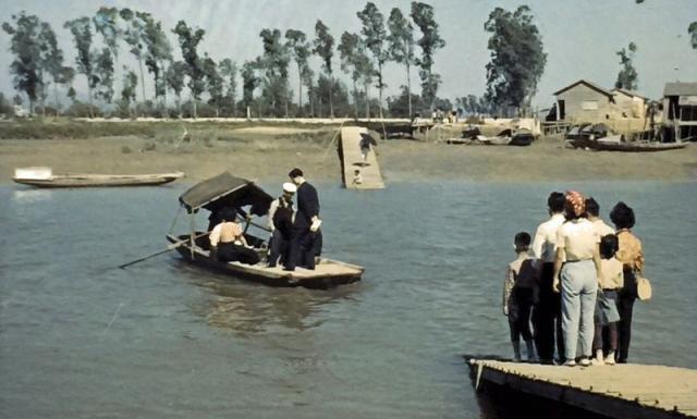
Thanks gentlemen. At least the photo is the correct orientation. From looking at hkmaps, it appears the current crossing point at Nam Sang Wai has not changed since the 1960s. But is it the same location?
Compared to the main photo, I'm missing the trees in the aerial photograph. Additionally, there are more buildings compared to the main photo. Same location?
Klaus, I think it does match if you flip the original images above. The tree line is possibly the one in front of the pond with the square island on it. The two houses in the images would be the ones on that side of the crossing on the right hand side (as opposed to the left). Just a thought anyway.
Phil, you're possibly right. In the main photo, at first sight it looks as if the trees and the houses have the same distance to the river. But when looking carefully, the line of trees is behind the houses. On the other hand, the aerial photograph shows a long path leading to the line of trees which is not in the main photo. Still more research needed.
Klaus, it could just be the viewing angle as to why the path isn't obvious. That said, on an aside, I noticed you uploaded an image from Tere Wong. Tere sometimes posts on Gwulo so perhaps they will be able to provide a definitive answer. Phil
I’ve now found so many references to this ferry route that show the same area as the main photo that I’m convinced the photo shows the Nam Sang Wai ferry.
I have amended the title to read "Nam Sang Wai River Crossing" to reflect the above discussion/comments and horizontally flipped the images that I have posted.
Comments
Possibly the same crossing.…
Possibly the same crossing.
Likely the same location here (No. 12). Photo said to be taken in the 1970s.
Same crossing
Yes, same crossing. Slightly different angle and time but you can see the tree line matches.
Re: Main Photo
Thanks gentlemen.
At least the photo is the correct orientation.From looking at hkmaps, it appears the current crossing point at Nam Sang Wai has not changed since the 1960s. But is it the same location?Location
Here is an aerial photograph from 1963 showing the area.
Compared to the main photo, I'm missing the trees in the aerial photograph. Additionally, there are more buildings compared to the main photo. Same location?
flipped
Klaus, I think it does match if you flip the original images above. The tree line is possibly the one in front of the pond with the square island on it. The two houses in the images would be the ones on that side of the crossing on the right hand side (as opposed to the left). Just a thought anyway.
Re: flipped
Phil, you're possibly right. In the main photo, at first sight it looks as if the trees and the houses have the same distance to the river. But when looking carefully, the line of trees is behind the houses. On the other hand, the aerial photograph shows a long path leading to the line of trees which is not in the main photo. Still more research needed.
1962 map
Here is a 1962 map:
Looks similar to the aerial photograph. Unfortunately, the map does not give any extra information to the location of the original photo.
crossing
Klaus, it could just be the viewing angle as to why the path isn't obvious. That said, on an aside, I noticed you uploaded an image from Tere Wong. Tere sometimes posts on Gwulo so perhaps they will be able to provide a definitive answer. Phil
It is the Nam Sang Wai ferry
I’ve now found so many references to this ferry route that show the same area as the main photo that I’m convinced the photo shows the Nam Sang Wai ferry.
moddsey suspected that the photos need to be flipped horizontally, and it seems so (also Andrew's).
Re: Main Photo
I have amended the title to read "Nam Sang Wai River Crossing" to reflect the above discussion/comments and horizontally flipped the images that I have posted.
Further images: