Current condition
Demolished / No longer exists
The aerial photo from 1 Feb 1945 shows there was one of the wartime cooking areas at this site. In the photo it has the same appearance as the cooking areas that can still be seen today in the valley above Quarry Bay, so this site would have had 10 platforms, with each platform having 8 wood-fired stoves, and each stove having a circular opening above it to support a large wok for cooking.
Photos that show this Place

1949

1949
2015
Comments
Outdoor WW2 Kitchen & Dams
I’ve relied on the excellent “HK Maps” website ( www.hkmaps.hk ) for the aerial photos in this post.
Here’s the 1949 view of the area with the northern tip of the Golf Course at the bottom and the stoves in the top right. Unfortunately, two photos join on the left making the part around the main stream difficult to understand.
Here’s a close-up of the kitchen and its immediate surrounds.
In addition to the stoves, three nearby areas show obvious signs of human activity.
Location 1. A patch of jungle has obviously been cleared.
Location 2. A cleared strip with a light line running across its middle.
Location 3. A thin dark line across the main stream.
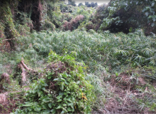
I visited in 2015, so if you plan to visit today please be aware that the situation on the ground has probably changed by now.
The whole area was easily accessible along the public footpath bordering the western side of the Golf Course. On reaching the back of the Golf Course the path enters the jungle, crosses a rickety old bridge over a stream and continues up the valley. Stay on the path for about 200-300 meters after the bridge, until it passes an unusually flat, open, area on the right, roughly the size of a tennis court. It was heavily overgrown with tall weeds, but strangely no trees. I think this was the location of the stoves.
Looking at this photo now, it just screams “snakes”, but I must have been dumber then and so just thrashed around in the weeds looking for the stoves, but without success. I expected the kitchen to have a hard, dry surface, but it was surprisingly boggy, making me wonder if it was an abandoned paddy field rather than the kitchen. The only man-made feature I found in the stove area was a low stone wall running along its eastern edge. The wall is obscured by undergrowth in the above photo, so here’s a close-up.
A few meters to the south of the stove area were some reinforced concrete structures. If I recall correctly, one or more were on top of a large rock.
I couldn’t make out what these had once been, but given that they were above head height, I wondered if they could have been anchor points for an awning.
Retracing your steps a few meters brings you to a small stream or channel with a vague path beside it leading down to the main stream. This, I think, is the line running across Location 2 mentioned above.
Rocks have obviously been cleared from this stream bed to assist the flow of water. I presume this was done to improve drainage of the boggy kitchen area and surrounds.
I’m fairly confident that I found Location 2, halfway along the small stream between the main path and the main stream. It was heavily overgrown with trees, but just about distinguishable from the undisturbed jungle. Looking from the stream, I couldn’t see anything of interest but didn’t enter for a proper search.
Following the small stream brings you to the main stream and Location 3, which is a dam wall. In fact, this stretch of the main stream between here and the rickety bridge boasts a series of dams. From memory there are three, but only one shows up on the 1949 aerial photo, probably because of the problem caused by the join between adjacent pics.
The dam nearest the rickety bridge is the largest, consisting of a thick concrete wall about two meters tall and ten wide.
The dam wall has been holed at its western end, I guess by explosives.
The next dam upstream is visible in the background of the last photo. Here’s a better shot. Again, it’s been demolished at one end.
The third dam has been holed in the middle.
Further upstream is this small weir.
The function of the weir was probably to stop debris being washed downstream and clogging up the water collection pools behind the three dams.
Can anyone please tell me who built and destroyed these dams and why?
An obvious candidate for builder would be the Deep Water Bay Golf Club, as the dams would be a very handy source for the large amounts of water I guess they need for watering the Course. If so, the dams could be over one hundred years old. Another possibility is that the dams were built to supply water for the outdoor kitchen. Thirdly, and less likely I think, is that the dams supplied water to the small squatter area that I vaguely recall at the base of Shouson Hill where it meets the Golf Course.
As for why they were destroyed, did the Government decide that public streams couldn’t be dammed for private purposes? Or maybe they were destroyed at the same time that the outdoor kitchen or squatter area were cleared?
I’ve recently seen the 1963 aerial photos (www.hkmaps.hk again) of Deep Water Bay which suggest that the wartime stoves had been removed by then, but I didn’t know that at the time of my 2015 visit. In 2015 I didn’t look for, or find, Location 1 mentioned above. I intended to return for another look but never got around to it before leaving Hong Kong. I’d be very interested to learn what, if anything, is at Location 1 today. Probably nothing, but you never know. Anyone up for the challenge?