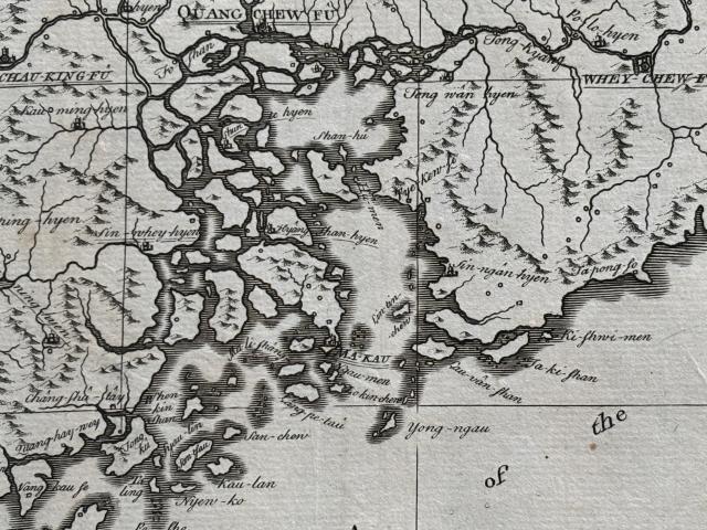
Recently bought a 1738 map of the province of Guangdong. Posting a closeup photo of the Pearl River Delta here.
Macau ("Ma-Kau") is labeled but not Hong Kong. In fact the entire HK area looks wrong but that's not surprising. Several HK places are named though:
- Lin-tin-chew
- Yong-ngau
- Lau-van-shan
- Ta-ki-shan
- Ki-shwi-men
- Sin-ngan-hyen
- Ta-pong-so
Would very much appreciate if other readers can find these places' Cantonese names, thank you.
The map is attributed to Jean-Baptiste Du Halde, a French Jesuit priest specializing in China, although he never traveled to China. The map is an English version, with this long title: "Province XII. Quang-Tong, Drawn on the Spot by the Peres de Tartre & Cordoso, in the Year 1714 with Improvements by ye Editor, is inscribed to Thos. Medlycott, Esqr."
If anyone would like to see the rest of the map or closeup of other areas, please let me know.
Comments
Map Names
My impressions. Items 1. and 7. are easier to deduce.
7. Dapeng Peninsula or Dapengbandao (大鹏半岛) is the peninsula to the east of Mirs Bay or Dapeng Bay.
Based just on the location…
Based just on the location on the map and ignoring the nomenclature, one can't help but surmise that:
3) Lau-van shan = Lantau Island
4) Ta-ki shan = Hong Kong Island
Of course back in 1738 Hong Kong island was not called Hong Kong island as it was a latter appellation by gweilos. Does anyone actually know what it was called by the local people back in the day? Could it have been 'Ta-ki shan'? Or was this yet another misspellation by Europeans? Shan means mountain. Just like Lantau Island was originally referred to its name by the mountain on the island but my understanding is Tai Yu Shan.
agreeing with moddsey and eurasian_david ...
Want to say I agree with what both of you wrote. I pulled out another map of the same area, made by the same Jesuit priest Du Halde but in 1745. That map also has (1) Lin-tin island in the same spot where Nei Lingding Island is today.
The 1745 map also has "Lan-tan or the Magpies" where Lantau Island is today
Lin-tin-chew - 伶仃洲, the old…
Lin-tin-chew - 伶仃洲, the old name of Lintin Island 內伶仃島
Yong-ngau - 滃崖, now called Miaowan Island 廟灣島, part of the Wanshan Archipelago in Zhuhai
Lau-van-shan - 爛頭山, the old name of Lantau Island, or less likely 流浮山 Lau Fau Shan marked at the wrong place
Ta-ki-shan - 扯旗山, the alternative name of The Victoria Peak, maybe translated from Tanka or Hakka dialects
Ki-shwi-men - 汲水門 Kap Shui Mun, probably marked at the wrong place
Sin-ngan-hyen - 新安縣 Sun-on County / Xin-an County, the historical administrative boundaries of Hong Kong and Shenzhen
Ta-pong-so - 大鵬所 alias 大鵬所城 Dapeng Fortress, a walled village in Shenzhen
wow, cwyip911, this is great!
Thanks for solving the mysteries for Yong-ngau and others. I never would have figured them out :)