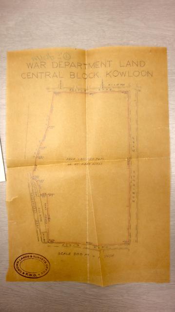
jamesho Fri, 05/14/2021 - 08:32 prevnextoldernewer WHITFIELD BARRACKS WDL12 Boundary PLAN Date picture taken 1930s Tags WDL12 WHITFIELD BARRACKS Author(s) HKRS337-4-110 Gallery 1930s Hong Kong Shows place(s) Kowloon Park - former site of Whitfield Barracks [????- ] Log in or register to post comments Comments Robinson Road. Elgin Road… Robinson Road. Elgin Road. Surely this must be much earlier than the 1930s Log in or register to post comments MacDonnell Road -> Canton… MacDonnell Road -> Canton Road Robinson Road -> Nathan Road Elgin Road -> Haiphong Road These name changes occurred in 1909 so this map has to pre-date 1909. MacDonnell Road was constructed in 1887, so this map has to be drawn up between 1887-1908. Could this WDL 12 map in fact date from 1891? Log in or register to post comments
Robinson Road. Elgin Road… Robinson Road. Elgin Road. Surely this must be much earlier than the 1930s Log in or register to post comments
MacDonnell Road -> Canton… MacDonnell Road -> Canton Road Robinson Road -> Nathan Road Elgin Road -> Haiphong Road These name changes occurred in 1909 so this map has to pre-date 1909. MacDonnell Road was constructed in 1887, so this map has to be drawn up between 1887-1908. Could this WDL 12 map in fact date from 1891? Log in or register to post comments
Comments
Robinson Road. Elgin Road…
Robinson Road. Elgin Road. Surely this must be much earlier than the 1930s
MacDonnell Road -> Canton…
MacDonnell Road -> Canton Road
Robinson Road -> Nathan Road
Elgin Road -> Haiphong Road
These name changes occurred in 1909 so this map has to pre-date 1909. MacDonnell Road was constructed in 1887, so this map has to be drawn up between 1887-1908.
Could this WDL 12 map in fact date from 1891?