Current condition
In use
When sloping down, Peel Street intersects but also runs parallel to Elgin Street, before reaching Hollywood Road. (^)
It is said to be one of the steepest roads in Hong Kong, with a slope of 1 to 4 in one part.
(^) thanks to David's work posted in 2010, which I only read after. It explains all, and how the latter part of Elgin Street came about. See 2nd comment below, for a brief recap.
Previous place(s) at this location
Photos that show this Place
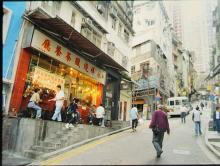
c.2006
Comments
naming of Peel Street
An added support may be Elgin Street in its proximity, which was so named with thought, to commemorate a person from the early years.
Please help to correct or enrich my findings with more information you know.
(+) interesting that the author tries to imagine this name tracing scenario 20 years further
(1953, sic) into future, in presenting his line of thought.
(^) 1840's
sources :
[1] Old Hong Kong (1933) (+)
[2] SCMP 1933-11-4
Pechili Terrace Elgin Street
recap :
"... the section from Staunton St to Shelley St (the section we see in the photo) was called Pechili Terrace, and the last section from Shelley to Caine Road was called Elgin Terrace."
I could see subject words clearly marked in the 1924 HK map within gwulo.
memory attested in photos (1984)
Unexpectedly came across this junction scene captured in a series of 5 photos (out of 7 or more) by a Japanese photographer in the 80s. So they illustrate a HK ordinary street life in this area truly.
The photos carry rich details, you may find more connection of the shops, persons and curios among them. The timing is likely before Chinese New Year.
(photo 1) egg shop on Staunton, vehicles heading West; calendar seems to show Jan. 20
(photo 2) next is a butcher shop and a fruits stall in front of it; round the corner, another stall with eggs
(photo 3) a wider view of the junction with more stalls shown, interestingly with the same roasted meat restaurant of previous generation (add the 'New' prefix in name later) - compare with the main photo
(photo 4) woman walking up steep Peel Street; Elgin on her left (street sign also), Peel on her right
(photo 5) standing on Staunton, looking eastward; on the far end, the red brick buildings is location of old Central Police Station;
shorter brick building on the right seems gone, if compared with today's street view of 'Tai Kwun'
These were the days when such daily street scenes and characteristics may attract the interests of visitors, for decades then. Queen Elizabeth's unscheduled visit to Graham Street market, it happened to be within two blocks down only, in 1975.
It might have been nervous to the security/bodyguards for quite a while, even though the photos may not reflect much (refer thread in 2022, https://gwulo.com/comment/62180#comment-62180).