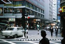
Submitted by moddsey on Thu, 02/07/2019 - 07:13 Current condition In use Date completed 1 Jan 1965 Previous place(s) at this location 1 Stanley Street [c.1891-c.1957] 42-48 Queen's Road Central [????-????] Log in or register to post comments Photos that show this Place 1967 1968 1970s Comments Manning House On the 1967 photo the following can be seen: Entertainment Building, D'Aguilar Street, and the Hing Wai Building, followed by Manning House. Log in or register to post comments
Manning House On the 1967 photo the following can be seen: Entertainment Building, D'Aguilar Street, and the Hing Wai Building, followed by Manning House. Log in or register to post comments


Comments
Manning House
On the 1967 photo the following can be seen: Entertainment Building, D'Aguilar Street, and the Hing Wai Building, followed by Manning House.