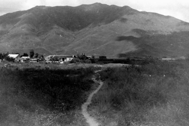
One of three rural scenes, probably in the New Territories, captured by an unknown member of the 367 Association. My guess is that it was taken looking to he North from somewhere in the Yuen Long area. Any suggestions?
Date picture taken
1950s
Gallery
Shows place(s)

Comments
Re: Kai Kung Leng, may be
Hi Andrew,
This one and the next one showed the same ridge so if we can pin it down, we would have both. It may be Kai Kung Ling. But I would need some refresher of the area to confirm.
T
Thanks Thomas. I believe…
Thanks Thomas. I believe that Kai Kung Ling is just to the North of the Sek Kong camp , where I am fairly certain the guy who took the photograph would have been stationed. Regards Andrew
Kai Kung Leng
I think it is Kai Kung Leng but I'm having a hard time finding a good match.
You three are the experts…
You three are the experts and I have high hopes that you can establish that the photographs are in the Kai Kung Leng area - and insert pins for all four of these recent additions. Any success with the row of buildings one fire damaged and another with a distinctive front - a theatre? Andrew
Re: Kei Kung Leng
Hi There,
I went to Kam Tiin earlier today but the ridge line is not an exact match despite some of the peaks appeared to be right. I suspect the photographer was standing close to the Au Tau side. Unfortunately I was walking along Kam Tin Road to Sheung Chuen for my return trip on the 51 KMB bus thus missed the chance to check on Au Tau's side.
Please zoom in and have a look,
T
Kei Kung Ling
Greetings. I think you folks have identified the site. First, thanks to Phil's advice, I now play with Google Earth. Similar features: A and B: spurs; C: valley and steep flat terrain to the right; D: a road(?) and sharp drop on the right. Regards.
Welcome to the investigation…
Welcome to the investigation. Peter. As I am totally unfamiliar with the area, whether from the 1950s or more recent years, I find it difficult to orientate things. Am I correct in my earlier guess that, for this photograph and the others that I uploaded recently, we are basically looking at Tai Mo Shan from somewhere to the West(?), possibly on the plain close to Sek Kong and with the photographer probably standing on the Route Twist before it starts to climb out of the plain. I'm probably miles off track!
Does the system allow any of you experts to place a pin on the map?
Best wishes to everyone. Andrew
Hi Andrew, referring to the…
Hi Andrew, referring to the photo I uploaded earlier (above), at mid-point horizontal, and 0.35 height, there is a school but I did not give it letter. I believe I have located this school on the 1952 map. So, your 367 friend has just left the camp and was walking towards the hill.