This is a cropped aerial photo of the western part of Hong Kong island, more specifically area around the PokFulam Filter Bed. The three rectangular-shape buildings on the top part of the photo are the three resident halls of HKU. The road on the top section of the righthand side of the photo is Conduit Road. It continues to the left side of the photo and then it loops back to the right side and becomes Po Shan Road. Hatton Road starts at the center of the photo, coming off Conduit Road, and continues towards the lower lefthand side of the photo. It makes an overpass at PoShan Road and continues uphill towards the peak of Hill Above Belchers (later called Long Fu Shan). Looks like when the photo was taken, Kotewall Road, which connects Robinson Road to Conduit Road near the Filter Bed, was not built yet.
Comments
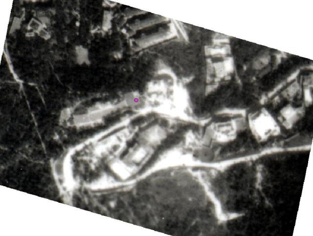
Aerial Photo of the PokFuLam Filter Bed Area
This is a cropped aerial photo of the western part of Hong Kong island, more specifically area around the PokFulam Filter Bed. The three rectangular-shape buildings on the top part of the photo are the three resident halls of HKU. The road on the top section of the righthand side of the photo is Conduit Road. It continues to the left side of the photo and then it loops back to the right side and becomes Po Shan Road. Hatton Road starts at the center of the photo, coming off Conduit Road, and continues towards the lower lefthand side of the photo. It makes an overpass at PoShan Road and continues uphill towards the peak of Hill Above Belchers (later called Long Fu Shan). Looks like when the photo was taken, Kotewall Road, which connects Robinson Road to Conduit Road near the Filter Bed, was not built yet.