Old Peak photos fascinate me, so thanks for posting.
Your photo may well have been taken from somewhere in the Bluff Path area, but I'm having difficulty identifying where No.4 Bluff Path was situated exactly.
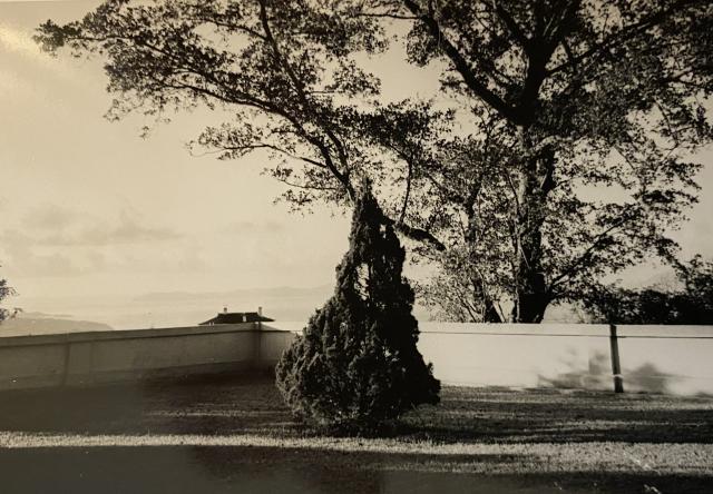
The roof of a distant building can be seen just above the garden wall. Here's a blow up.
a. A central top-ridge runs left to right. At first I thought there was a break in it above the middle chimney, but now I think it's just smoke rising from that chimney.
b. Below the top-ridge, the roof drops at a very steep angle before adopting a much shallower gradient.
c. Three chimneys. The left and middle chimneys are both on the side of the roof facing the camera. The left one emerges from or near the top-ridge, towards its left end. The middle one is about half-way along and close to the nearest edge. The right one is on the side of the roof facing the right, close to where the angle of the roof changes, and is the tallest of the three. The tops of the left and right chimneys are at the same level.
d. The roof corners and ends of the top-ridge have upward curving ornamental spikes.
It's the dark roof in the background. Ignore the flat roof in the foreground.
Features a, b and c of the roof in your pic are clearly seen in this roof. Feature d, the upward curved spikes, are very blurred in the extract, but are easier to see by zooming in on the original. I think the two roofs are one and the same.
If the roof in your photo really is the East House of Gough Hill Quarters, then the photographer must have been standing behind (north), slightly to its left and slightly higher than it. This 1950's map extract shows the neighbourhood, with Gough Hill Quarters near the bottom.
Bluff Path is near the top, and there are lots of other buildings between Bluff Path and Gough Hill Quarters. If your photographer was on or near Bluff Path, then all the buildings in between him or her and Gough Hill Quarters must be out of sight behind the garden wall. Similarly, the West House of Gough Hill Quarters can't be seen in your photo. The only explanation I can think of is that it's hidden by the tree. Unsure if either of these suggestions would stand up to reality as perspective can be difficult to predict.
Let's assume that your photographer was indeed in a garden on Bluff Path. He didn't have many to choose from. The map shows only three buildings, namely "Knock Laye", "Galesend" and "Hill Side", accessible from Bluff Path. A line marks the southern boundary of "Knock Laye" and includes a 90 degree angle. It's tempting to think that this line represents the garden wall in your photo as the right-angle is at approximately the same position relative to Gough Hill Quarters in both the map and your pic.
You mentioned that you think that your home on Bluff Path was No.4. The map extract labels the three Bluff Path buildings as No.300 ("Knock Laye"), No.302 ("Galesend") and No.303 & 304 ("Hill Side"), but there's no No.4. Peak properties were renumbered at various times, so perhaps a renumbering exercise took place between the map being drawn and your residency. Do you remember where your home was situated on Bluff Path, e.g. on the left or right going uphill?
The background of your photo shows three land masses rising from the sea in the distance. If the afore-mentioned roof was really Gough Hill Quarters, then the camera was pointing almost due south. If so, the long, thin, finger of land that runs to the left from the tree should be south-west Lamma. Unfortunately, I've tried and failed to identify the two land masses at the left edge of the photo just above the garden wall. They should be Ap Lei Chau or the Brick Hill Peninsula, but they just don't look similar.
To summarize, based only on the roof identification, I think this is a view taken from somewhere to the north of Gough Hill Quarters, possibly Bluff Path, looking south. I'm far from 100% sure due to questions over perspective and failure to identify the background. As always, alternative suggestions welcome.
I've also been unable to identify where #4 may have been located. On the hkmaps 1965.1 map you can clearly see numbers 1, 3, 5, 7and then on the opposite side of the road you can see 6 and 10.
There is a #4 - also called "The Mount" - but this looks more to be related to Peak Road rather than Bluff Path. It'slocation is now occupied by the Strawberry Hill development.
However, I think the background may consist of the following: the long island in the far distance is east lema island (now known as Dangan). The two headlands a bit closer, and I stress this is just a guess, correspond to the Stanley peninsula and the southern tip of Po Toi behind it. The angle and the height of the garden just seems to have blocked out every useful landmark that could corroborate the location.
Edit: I'm going to firm up my guess and say this is the garden of either 1. The Mount or 2. ) #1 Bluff Path. Both properties have garden terraces with right-angled walls that when a straight line is drawn between there and Dangan Island result in the line going over where the east house of the Gough Hill quarters were located. Could it be that the mystery #4 Bluff Path is actually #1 and has just been incorrectly transcribed at some point?
It could be but the available images show (imo) slightly stockier chimney stacks on Galesend. Also the roofing on Galesend seems to lack the "curve" at the edges compared to the roof on the original photo.
We lived in Galesend in the early 80s and unless the house had been rebuilt since the 1960s (I don’t think so, but I’m not sure) that is definitely not the Galesend roof.
The grounds of Galesend were surrounded by a low white wall so when I first saw the photo of the mystery #4 Bluff Path I thought it might have been taken from Galesend. But I have dug out a photo and our wall around the front garden was lower than the one in the picture. There was also a small side garden surrounded by a fairly high hedge, which could have had a wall like this behind it. If that was indeed the garden and wall shown, you can imagine the photographer standing just below the “s” of the Galesend on the first map and looking out over the building 294 also on the map.
I have no photos of the view in that direction apart from a rather silly one of our dog in the side garden, with the hedge in the background and trees beyond the hedge.
I do have 2 photos of the front of the house showing slightly different views which I can upload tomorrow if they are of interest.
Apologies for the delay in posting these. You can see that the exterior of the house is very different from the older photos of Galesend, but there were still some similarities which make me think it might have been a makeover rather than a complete re-build. There was still a narrow conservatory-type full length room alongside the sitting room, which appears from earlier photos in the original house. The staff quarters and garage were in the same place, and the front garden the same apart from the addition of the swimming pool!
I think it is possible that the original photo above could have been taken from the side garden, which you can't see in these photos.
Just another attempt to look at some of the possibilities, based on the apparent configuration of the chimneys of the (presumed) Gough Hill Quarters (GHQs).
It appeared that the possibility of being taken from Bluff Path 1 or The Mount could explain how the chimneys of eastern GHQs looked like in the photo.
The chimneys of west GHQs were also examined in the same manner. The line of sight lands on nowhere similar to the foreground of the photo, and considerably far away from Galesend. Compared to Bluff Path 1 or The Mount, the chance that the photo was taken from Galesend is relatively lower with the clues available.
Comments
No.4 Bluff Path?
Hi Bob,
Old Peak photos fascinate me, so thanks for posting.
Your photo may well have been taken from somewhere in the Bluff Path area, but I'm having difficulty identifying where No.4 Bluff Path was situated exactly.
The roof of a distant building can be seen just above the garden wall. Here's a blow up.
It has some quite distinctive features;
a. A central top-ridge runs left to right. At first I thought there was a break in it above the middle chimney, but now I think it's just smoke rising from that chimney.
b. Below the top-ridge, the roof drops at a very steep angle before adopting a much shallower gradient.
c. Three chimneys. The left and middle chimneys are both on the side of the roof facing the camera. The left one emerges from or near the top-ridge, towards its left end. The middle one is about half-way along and close to the nearest edge. The right one is on the side of the roof facing the right, close to where the angle of the roof changes, and is the tallest of the three. The tops of the left and right chimneys are at the same level.
d. The roof corners and ends of the top-ridge have upward curving ornamental spikes.
The East House of Gough Hill Quarters (https://gwulo.com/node/28292) had a very similar roof. The best photo of it I can find is at https://gwulo.com/media/30948, from which I've taken this extract for comparison.
It's the dark roof in the background. Ignore the flat roof in the foreground.
Features a, b and c of the roof in your pic are clearly seen in this roof. Feature d, the upward curved spikes, are very blurred in the extract, but are easier to see by zooming in on the original. I think the two roofs are one and the same.
If the roof in your photo really is the East House of Gough Hill Quarters, then the photographer must have been standing behind (north), slightly to its left and slightly higher than it. This 1950's map extract shows the neighbourhood, with Gough Hill Quarters near the bottom.
Bluff Path is near the top, and there are lots of other buildings between Bluff Path and Gough Hill Quarters. If your photographer was on or near Bluff Path, then all the buildings in between him or her and Gough Hill Quarters must be out of sight behind the garden wall. Similarly, the West House of Gough Hill Quarters can't be seen in your photo. The only explanation I can think of is that it's hidden by the tree. Unsure if either of these suggestions would stand up to reality as perspective can be difficult to predict.
Let's assume that your photographer was indeed in a garden on Bluff Path. He didn't have many to choose from. The map shows only three buildings, namely "Knock Laye", "Galesend" and "Hill Side", accessible from Bluff Path. A line marks the southern boundary of "Knock Laye" and includes a 90 degree angle. It's tempting to think that this line represents the garden wall in your photo as the right-angle is at approximately the same position relative to Gough Hill Quarters in both the map and your pic.
You mentioned that you think that your home on Bluff Path was No.4. The map extract labels the three Bluff Path buildings as No.300 ("Knock Laye"), No.302 ("Galesend") and No.303 & 304 ("Hill Side"), but there's no No.4. Peak properties were renumbered at various times, so perhaps a renumbering exercise took place between the map being drawn and your residency. Do you remember where your home was situated on Bluff Path, e.g. on the left or right going uphill?
The background of your photo shows three land masses rising from the sea in the distance. If the afore-mentioned roof was really Gough Hill Quarters, then the camera was pointing almost due south. If so, the long, thin, finger of land that runs to the left from the tree should be south-west Lamma. Unfortunately, I've tried and failed to identify the two land masses at the left edge of the photo just above the garden wall. They should be Ap Lei Chau or the Brick Hill Peninsula, but they just don't look similar.
To summarize, based only on the roof identification, I think this is a view taken from somewhere to the north of Gough Hill Quarters, possibly Bluff Path, looking south. I'm far from 100% sure due to questions over perspective and failure to identify the background. As always, alternative suggestions welcome.
Bluff Path House Numbers in 1960's
Hi Bob,
Further on the topic of the 1960s numbering of the three houses on Bluff Path.
This 1960's Peak Map labels them as;
No. 5 & 7 - Hillside.
No. 6 - Unnamed house on the site of Galesend.
No.10 - Unnamed house on the site of Knock Laye.
Unfortunately, No.4 not mentioned.
4 Bluff Path
I've also been unable to identify where #4 may have been located. On the hkmaps 1965.1 map you can clearly see numbers 1, 3, 5, 7and then on the opposite side of the road you can see 6 and 10.
There is a #4 - also called "The Mount" - but this looks more to be related to Peak Road rather than Bluff Path. It'slocation is now occupied by the Strawberry Hill development.
However, I think the background may consist of the following: the long island in the far distance is east lema island (now known as Dangan). The two headlands a bit closer, and I stress this is just a guess, correspond to the Stanley peninsula and the southern tip of Po Toi behind it. The angle and the height of the garden just seems to have blocked out every useful landmark that could corroborate the location.
Edit: I'm going to firm up my guess and say this is the garden of either 1. The Mount or 2. ) #1 Bluff Path. Both properties have garden terraces with right-angled walls that when a straight line is drawn between there and Dangan Island result in the line going over where the east house of the Gough Hill quarters were located. Could it be that the mystery #4 Bluff Path is actually #1 and has just been incorrectly transcribed at some point?
4 Bluff Path
Could it be the roof of "Galesend"?
Galesend
It could be but the available images show (imo) slightly stockier chimney stacks on Galesend. Also the roofing on Galesend seems to lack the "curve" at the edges compared to the roof on the original photo.
Galesend
We lived in Galesend in the early 80s and unless the house had been rebuilt since the 1960s (I don’t think so, but I’m not sure) that is definitely not the Galesend roof.
The grounds of Galesend were surrounded by a low white wall so when I first saw the photo of the mystery #4 Bluff Path I thought it might have been taken from Galesend. But I have dug out a photo and our wall around the front garden was lower than the one in the picture. There was also a small side garden surrounded by a fairly high hedge, which could have had a wall like this behind it. If that was indeed the garden and wall shown, you can imagine the photographer standing just below the “s” of the Galesend on the first map and looking out over the building 294 also on the map.
I have no photos of the view in that direction apart from a rather silly one of our dog in the side garden, with the hedge in the background and trees beyond the hedge.
I do have 2 photos of the front of the house showing slightly different views which I can upload tomorrow if they are of interest.
Galesend pics
Hi Ismall,
Yes please to your kind offer to post Galesend photos.
Galesend Bluff Path c. 1984,…
Galesend Bluff Path c. 1984,…
Galesend Photos
Apologies for the delay in posting these. You can see that the exterior of the house is very different from the older photos of Galesend, but there were still some similarities which make me think it might have been a makeover rather than a complete re-build. There was still a narrow conservatory-type full length room alongside the sitting room, which appears from earlier photos in the original house. The staff quarters and garage were in the same place, and the front garden the same apart from the addition of the swimming pool!
I think it is possible that the original photo above could have been taken from the side garden, which you can't see in these photos.
another attempt
Just another attempt to look at some of the possibilities, based on the apparent configuration of the chimneys of the (presumed) Gough Hill Quarters (GHQs).
It appeared that the possibility of being taken from Bluff Path 1 or The Mount could explain how the chimneys of eastern GHQs looked like in the photo.
The chimneys of west GHQs were also examined in the same manner. The line of sight lands on nowhere similar to the foreground of the photo, and considerably far away from Galesend. Compared to Bluff Path 1 or The Mount, the chance that the photo was taken from Galesend is relatively lower with the clues available.