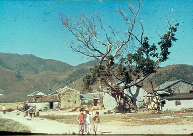
If this is Yuen Long, which Paddy described it as being, I think it must have been on the Eastern outskirts, as the centre was much more built up by 1958.
CORRECTION (2020-05-15) After a great deal of excellent detective work by several readers including terewong, philk and tngan, the location of the old slide has definitely been fixed as been taken close by what is now the Tin Sum Village Office. Readers might find it interesting to read their contributions and see the final Street View image taken from more or less the same spot. The camera used to take the old slide photograph would have been pointing to the West and the scene is a few miles to the West of Yuen Long. Thanks everyone! Andrew
Date picture taken
1958
Gallery
Shows place(s)
Comments
My observations to kick start
My observations to kick start search:
White Chinese grave on hilliside to right of picture. Typically for good feng shui, grave would be south facing with 'higher mountain' behind and 'lower mountains'' to side and no 'high mountains' in front (check). Typically flowing water in front (so may need to look for stream or river in front).
The hilly terrain is getting lower from right to left of picture (assuming photo is not flipped!) .
Large flat plain (paddy fields?) in front of Chinese grave (as per good feng shui)
Best fit: location would be the lower hills of the west end of Kai Kung Leng mountain range in Yuen Long. We are likely looking at one of the small villages sitting in the Kam Tin area of Yuen Long. Can see numerous Chinese graves on lower southern hillsides of Kai Kung Leng mountain range (none to north as per feng shui) on Google Earth.
I may even say centre of gravity would be vicinity of Fung Kat Heung
Thanks for a promising start
Thanks for a promising start and I agree with most of your observations. I think we can be fairly certain that the photo has not been flipped. On Google Earth the area around Fung Kat Heung seems to be the right sort of area. My slight reservation is that in the 1950s places such as Fung Kat Heung would have been quite a way from the 'beaten track' of the main road, and similar views were readily available without going away from it. I agree that the white structure on the hillside on the right of the photograph does look exactly like a Chinese grave but it is much larger than any that I have seen.
Thanks Andrew, and taking on
Thanks Andrew, and taking on board what you said, where Route Twisk joins Lam Kam Road and continuing on to where it birfurcates to Kam Tin Road and Kam Sheung Road - I think somewhere within the first Km of that section of Kam Tin Road should be the better angle to get the right skyline. Difficult to find one (so far) on Google Earth with modern buildings / foliage.
Checking around the mountain
Checking around the mountain lines of the photo, the Kai Kung Leng (雞公嶺) in Kam tin looks similar .... 80%
After that, I checked the mountian line of Sheung Yu River and finally suspect about the area at the Nei Wai village
Another angle at Sheung Yu
I suspect it is Nei Wai 坭圍 in Tuen Mun, formerly belongs to Yuen Long district.
Travellers passed by this village at the Castle peak road and took this photo at the corner of the village
Yuen Long
I think Terewong is heading in the right direction. The closest match to the ridgeline I have found yet is actually at the north end of the Castle Peak ridgeline, close to where the Ha Tsuen interchange is today. So I think this may be one of the wall villages that used to be in that vicinity. It's just a bit hard trying to find an appropriate location on old maps, but I think somewhere in the vicinity of Ha Tsuen looking SW.
BTW, this would mean the image is flipped.
yeap, let's finding around
yeap, let's finding around there
... there is no "corner tower" in the photo, so it may not be Nai Wei 坭圍
Refer old Nai Wei photo By Roger W@flickr
Roger WFollow New Territories - Fortified Village
https://www.flickr.com/photos/24736216@N07/3472623975/in/album-72157616802750089
Here is a flipped version of
Here is a flipped version of the image . Does it add anything to the discussion?
ERROR: No media found for mid=42816
This is almost there I think:
This is almost there I think:
https://earth.google.com/web/search/Tin+Ha+Road,+Ha+Tsuen/@22.43528594,113.99033081,8.91542625a,0d,60y,280.54991427h,89.22095936t,0r/data=CigiJgokCWNyl08SdTZAERv87AdubjZAGUizowKzf1xAIRz8U_OEflxAIhoKFnFjaWFLRkphNGFzanVEMzZnWndGdWcQAg
After looking at the ridge more closely I have reassessed and think that our location is somewhere west of Tin Sam village.
Phil. Now that the original
Phil. Now that the original photo has been flipped, I feel pretty sure that you have found the appropriate skyline on Google Earth. Google Earth comes up with Tin Sam as being basically just to the West of Sha Tin, and nowhere near Yuen Long - or is there another Tin Sam roughly in the Yuen Long area? You have done a great job in finding what looks very much like an excellent match of the skyline.
Tin sam
There are quite a few similar/same village names in HK, but the one I am referring to is between Yuen Long and Tuen Mun near Hung Shui Kiu.
I found an exact match for the ridgeline but have yet to find a match for the buildings on the image. It may take a while.
Thanks Phil. According to
Thanks Phil. According to the aerial photograph there is another village immediately at the foot of the hills to the West of Tin Sam, but no such village appears on 'Paddy's' photograph - only the Chinese grave. Maybe the camera angle points further to the South West, or perhaps a location a bit further to the South of Tin Sam might be worth looking at? It also seems on his photograph that the buildings are fairly close to the foot of the hills.
Chinese grave
I've only gone back as far as 1961, but there is an aerial image of the area that shows a single grave in exactly the same spot that can be seen on your image. Actually, you can see it in the 1963 aerial images as well. Given the viewpoint I already worked out, there was a village, more or less circular in shape, that corresponds to where I would expect to see the buildings in the photo. The village is no more it seems, replaced by small industrial units I think, but it was located in the open space between the LTR track west of Tin Sam and the Kong Sham Western Highway. Perhaps this is the one you are referring to.
I've edited the following image (from 1963) to give a rough idea of the line of sight of the photographer. Unfortunately, even though the 1961 imagery has greater contrast, the detail is not as great due to the height it was shot at (30000 ft) so I haven't bothered using it here. The circle encloses the hillside grave. The right side of the open box is where the open area west of Tin Sam Village currently stands (that I linked to in GoogleEarth). You can faintly see the circular village I am referring to at the top of the box touching the top red line.
perhapsPsomeone with greater local knowledge would be able to put a name to the settlement or is able to use this to narrow down the actual position of the photographer.
Re: Chinese grave
Hi There,
Street view could not give a good look, but Google Earth seems to be able to see the same grave and it appeared to be substantial.
I looked up Tin Sam Village Office, Hung Shui Kiu, then change the viewing angle and direction and got the above. The highlighted location appeared to be the same grave. Walking there from Tin Sam may take sometime though. I'm not familiar with the area. I have only been to Hung Shui Kiu along the Castle Peak Road within a few blocks, and the Hung Fuk Estate areas. Never been to Tin Sam Village before.
Also, there are more trees now since the photo was taken. Line of sight previous possible in the 1950s may be obscured.
On the other hand, the difficulty of spotting other reference is that, much of the farmland had been changed and many of them is now called the brown land zones, used as parking lots of trucks, container depot, or godowns. We would probably need someone who grew up in the Yuen Long area frot this, at leat to confirm the ridge lines as those should be the only elements that stayed the same for decades.
T
Thank you both for your
Thank you both for your detective work. Tngan's screen shot neatly matches the flipped photograph, so with a bit of luck we might be able to use the 1963 aerial photograph to pinpoint the location of the tree and house. Then, we'll have to try to insert a pin in the right place on the Gwulo map! I see on Google Earth that there are quite a lot of Chinese graves on the hillside and, bearing in mind the position of the large one on 'Paddy's' photograph being just to the left of the valley leading up to the lower rounded hill, it might be possible to find it from the new dual carriageway road on Google street view which next to an industral unit provides an uninterrupted view of many graves, one of which is much larger that the others - although it looks fairly recent. That might lead us back to a likely location for the tree and house.
Spending time in the lunch to
Spending time in the lunch to compare the buildings in the old photo with Tin Sum Tsuen (village)
I think it is the place where the photo has been taken
Put together with a 1960s 1
Put together with a 1960s 1 in to 100 ft Topographic Map (1:1200)
Bingo!
Excellent find terewong. It looks like you have found the exact spot, great detective work. Maybe Andrew can now flip the original and put in the place name.
philk, thanks for your hints
philk, thanks for your hints indeed ~ tere
Also thanks for Andrew's sharing
Now this is the location of
Now this is the location of the Tin Sum Village Office
https://maps.app.goo.gl/8V6d8UQWZahdM1pr8