Pool in Lai Chi Kok – is it still there?
I am searching for information about the swimming pool in Lai Chi Kok where I swam in 1955 -1956. It was on a property next to Castle Peak Road now part of Greenwood Villas and address as 1 Chung Shan Terrace. Any information on the history of the pool, the building next to it and their current status would be much appreciated.

Each trip to the pool started with a walk from the rear of the Lai Chi Kok Amusement Park. In
my first visit, there were still some vacant lots. I remember some details about the place. I also remember standing on a dirt road outside the property, and watched a car rounding a dirt road curve towards (noted later) Castle Peak Road.

At the west side entrance, a man sat on a chair and collected money from the pool users. The cost was about 60 cents which was slightly more than that at the amusement park.
Between the pool and the building, there was a short walkway. By the walkway was a tall stone entrance sign. Once inside the building, the showers were about a dozen steps to the left, a worker at the reception desk and stairs behind him to the upper level. Later, I learned that the place was operated by a staff from the amusement park possibly as a guest house or hotel. The number of rooms could not have been large given the size of the building. It was nice of him to open the pool to the public.
[Insert photo 4 (springboard girl) and photo 5 (current air photo) here]

Recently, I saw a photo showing a pool and a tall stone entrance sign similar to the one I remember at Lai Chi Kok. I mistook it was at Lai Chi Kok. After some discussions and research, contributors at Gwuo (philk, Fivestars, and others) identified its location in Yick Yuen, Lantau Island.
The two signs look similar - type of stone, shape and size, flat roof canopy, and the half- circular planters at the front. Not visible is what I remember a small outdoor cooking and food serving area under the canopy.
A current Google Earth photo shows what appear to be the original pool and building. This needs further research to be confirmed. Two bits of my memory may be faulty. One is the location of the springboard which I believe was on the east (long) side. It could be a low level springboard, and the higher springboard was at the north end where the water was deep. Next, the tall entrance sign might be actually a part of the wall next to the door. A visit to the site may help clear up these uncertainties, but I understand the area is now a gated community.
Photos that show this Place
Comments
pool?
Hi Peter
This structure you have highlighted as a pool is in fact a garage. I'm fairly certain that the property here is the original one from when the land was developed and the footprint of both the house and detached garage haven't changed over the years.
I'll try and get over there at some point in the next few days and take some up-to-date photos.
Phil
Pool?
Thank you Phil for the latest information. A thought at this stage. I believe after they closed the hotel busness, they or subsequent owner built the garage using the pool's wall foundation. Regards Peter
Pool
It's possible Peter, but then it would have been a tiny pool, not much bigger than a car.
Edit: kpl has kindly uploaded a recent image.
Pool
Wonderful! Thank you Phil and kpl for the photo.
Phil, sorry I misunderstood your previous post. I thought they built a huge commercial garage taking up the footprint of the rectangular area (2017 air photo) that I believe was at one time a pool. From the air photo, the only thing I can go by, it appeared to be an abandoned pool, and now (?) a flat roof structure given the shadow on the ground as hint. Regards, Peter
Off topic: that looks like a
Off topic: that looks like a BMWi3!
garage
Hi Peter, sorry for the misunderstanding, I was using the term "garage" in the British sense i.e. for storing a car.
The garage in question appears to be the same one that has always been at the property - the same shape and size (especially relative to the house, which is the same as when first built). Could there have been a pool there that was exactly the same shape and size and hence the confusion? Sure, but I doubt very much, given its size, that it would have had a springboard and deep end and have been large enough to accomodate more than just a very few people...there just isn't enough space. Perhaps one of the other properties had the pool you recall.
Phil
From Pool to Garage
Hi Phil, thank you for your interest and help. I cannot think of an alternate building with location and features that match my memory. The walk uphill to the last building, the memory of seeing a car rounding the curve outside the "pool" house. I recognize after almost seven decades, memory and details can erode and change.
From previous discussions, I now think that the the rectangular-shape outline in the 1963 air photo and the current (2017) photo are one and the same, not a pool anymore, in fact already a one level building. It might have taken on the pool's wall foundation, but this is only an assumption.
kpl's photo shows a house of a faily new design. Its roof, according to the two air photos mentioned above, has remained the same. I noticed the dimentions of the roof's edges don't appear to match, but this is not important.
On the left of kpl's photo an important clue is that it shows I believe the separating wall between the two properties, which is parallel to the long side of the rectangular building. It appears to me that the garage roof was built high to match that of the bulilding. Is that a low level wall I am looking at?
The 1963 air photo tells me there is not enough space for a small garage, but the 2017 air photo appears to say it's possible. Regards, Peter
1966 Exterior
A photo of Chung Shan Terrace appears at: https://digitalrepository.lib.hku.hk/catalog/s7526g21r#?c=&m=&s=&cv=&xywh=-62%2C-55%2C1123%2C1085 No change to the exterior.
1966 Exterior
Thank you moddsey for the link to the 1966 photo. My comment about the building design is misleading. I should have been more specific, which is about the walkout and its roof extension. Regards, Peter
Chung Shan Terrace
I lived with my parents and siblings in No. 4 Chung Shan Terrace from 1952, in Wharf Company quarters. Two storey apartment blocks, a long walk up from the bus!! There was a different type of residential building at No. 1 - grey stone rather than cream as our homes were - never knew of a pool but I think the person who ran / owned the amusement park lived there - I learned to swim at the Amusement Park, and to roller skate!! Later the hillside below us was developed into numerous blocks of smaller apartments and we were moved by the Company to Kowloon Tong.
I’ll be over there next Tuesday
I can be your remote video cam as I walk around if you want to FaceTime.
Chung Shan Terrace
Thank you 12Sunnry for sharing your memories about Chung Shan Terrace. I believe your home was on the north side of the road and fourth counting from Castle Peak Road.
I wonder if the path you took between home and the amusement park was similar to mine. I started from the rear of the park and walked north in the open field, then turned right (east), climbed up a steep embankment and crossed two country roads before reaching your community. Next was a bit more uphill to the top of your street before turning southward. I must have walked by your home, and now remember though not strongly, the two storey building on my left. There were still a few empty lots in 1955. I did not know any shorter path given the contours and vegetation south of Chung Shan Terrace.
You may remember a girl at 2 Chung Shan Terrance two doors to your left. She is my sister's classmate at St. Mary's, and invited us to swim next door where the place was operated by a high level staff at the amusement park. I think very few people, then and now, know about the pool unless they have used it or stayed at the hotel. It would be nice to find any evidence or remnant of the pool. Regards, Peter
I think we at No. 4 and the
I think we at No. 4 and the one to our left facing the buildings were occupied by Kowloon Wharf people - certainly in 1952-54. I had to get the bus home from Star Ferry (where I dropped off the bus from KGV) which originally stopped way down and I had to walk past beach huts/swimming pavillions, the amusement park, a paddy field and up the hill. There was a track down to the Village but I used the road all the way. Eventually the No. 6 bus came as far as the amusements so shortened the walk somewhat...white KGV uniform did help!
I think the whole area changed dramatically in my 36 years in Hong Kong! Would get well and truly lost now.
Chung Shan Terrace
Just wondering, are the white two-storey houses up the hill Chung Shan Terrace?
Chung Shan Terrace
Thos are certainly Chung Shan Terrace.....the lowest one was on quite a hairpin bend and the village pathway went down on that bend on the left of the photo.
I think the white buildings behind the amusement park were two blocks of flats called Happy Villas and housed UK RN or Military families in my day. The paddy fields were behind them. If you drove up Chung Shan Terrace and turned left into Castle Peak Road at the top you would come down to what was a leper hospital and then on into more built up areas. Sham Shui Po and Mong Kok etc.
I think the No. 16 bus went from Jordan Road ferry terminal on the upper route and No. 6 from
Star Ferry along the bottom!!
1956 Lai Chi Kok Map
1955 Chung Shan Terrace
Chung Shan Terrace
The highest blocks in the photo are Chung Shan Terrace as they were, then the buildings lower down started to go up.....I would not recognise it after all these years. Left there in about 1954-55 for Wharf quarters in Cambridge Road, Kowloon Tong, then to St George's Court in Kadoorie Ave. When I married in 1964 lived over in Pokfulam and eventually left Hong Kong in 1986. Thank you for sharing.
Chung Shan Terrace 1955
Thank you moddsey for this 1955 photo. On the far left where the road runs uphill is about the spot I crossed after walking up the embankment from the amusement park. A bit more walking uphill followed before reaching the buildings along Castle Peak Road.
A comparison of the 1963 air photo with current Google Earth view shows that a few original buildings still stand today based on the size and shape of their roof. One example is the building on the second row with six walkout balconies. Using the 1963 photo as reference, to the right and behind this building are the four buildings along Castle Peak Road, the one closest to the junction barely visible on the far right. Regards, Peter
Chung Shan Terrace 1955
InsertAt first I thought there was nothing that I could add to this discussion but as it had its origins in the Springboard girl photograph and Peter's memory of his visits to a house and pool on the Chung Shan Terrace I have followed the thread and was pleasantly surprised to realize that I visited the old Lai Chi Kok Amusement Park site in 1981, when I went to the Sung Dynasty Village, built there. Over the past 40 years or so I have never known exactly where this was except that it was somewhere in the Western area of Kowloon. To realize that it was actually built on the site of the old Lai Chi Kok Amusement Park raises all sorts of questions about who developed it and when, etc. Perhaps those with a more detailed and local knowledge of the history of Hong Kong might be able to contribute something on that.
Meanwhile, I have added an excellent aerial 3D image from Google Earth that shows where the Sung Dynasty Village (and earlier, the Lai Chi Kok Amusement Park) were and, especially, the two storey house at the right hand end of the upper terrace that is the one remembered by Peter. There is also my 1981 photograph of the acrobats in the Sung Dynasty Village that shows one of the rows of Greenwood Apartments up on the Chung Shan Terrace, but Peter and I suspect that this was on a lower section of the terrace.
FaceTime
My apology annelisec, I now realize your post is an offer to help. I know nothing about FaceTime and had to look it up. It appears one needs modern and mobile technology none of which I have. It would nice if the current owner could show the place to a stranger, talk about the history of the place, and point to any - I hope - hint or remnants of a swimming pool. Again, thank you for the offer. Regards, Peter
Chung Shan Terrace
My goodness - what a difference 70 years can make!!!! Lai Chi Kok and Chung Shan Terrace have taken on quite a different importance and status by the look of that photograph. I am so pleased to see it as it is now, thank you.
Borrow one
Find someone with an iPhone in your household or neighborhood who uses FaceTime .. and borrow it and them for 10 minutes. There are a minimum of 100 people within a quarter mile radius of you with an iPhone, so… :-)… No excuse bucko (smiley face). The 15 to 18 year olds are always happy to show off.
At a minimum write a note in these comments for the owner, and I will drop it off at the house for you tomorrow.
Pool In Lai Chi Kok, still there?
Thank you for the advice. My children have left the nest, I live in a senior neighbourhood. No grand-children yet.
Here are my notes kindly for you to relay to the owner:
1. I was 10 years old in 1955 when I swam on several visits in a pool belived to be situated at your place, it was operating as a hotel and part of the Lai Chi Kok Amusement Park.
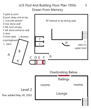
2. I remember the layout of the place and its ground level interior which, after many years, I admit, is no longer the same today. (lay out plan enclosed)
3. Some remnants of the original property, I hope, may still exist - below ground foundation of the stone wall entrance sign, original foundation wall of the swimming pool.
4. The neighbourhood is now a gated community. I was not able to visit the site when I returned for visit in 2014.
5. Any information confirming or otherwise about my memories would be greatly appreciated.
Sincerely, Ex-Hong Konger Peter Yee, Canada
So to confirm, I'm to drop it
So to confirm, I'm to drop it off at the house in the photo posted by kpl ?
Please delete - duplicate
So to confirm, I'm to drop it off at the house in the photo posted by kpl ?
Pool in Lai Chi Kok - is it still there?
Yes, please, annelisec.
We need to offer the owner a way to respond if they don't answer the door bell:
1. reply by phone to you?
2. post a response at this Gwulo page -https://gwulo.com/node/58489 ?
or email to David@gwulo.com ?
3. other options?
Thank you very much for your help. Hope they give you a tour and allow taking photos. You can get from David my email address. Regards, Peter
Letter delivered to the
Letter delivered to the helper who said the owner was at the office. I especially pointed out the website name. I gave my HK phone number as a text message contact. The nice guard at the top of the hill also heard my story, so I hope it will travel
now I'm offf to the airport.
Chung Shan Terrace
Thank You, annelisec, for your help. Regards, Peter
(Edit: May 26, 2022) For simplicity, I have added Level 2 floor plan to the earlier post.
"You left a note …
"There has never been a swimming pool in all the houses at C S T. The closest swimming pool was inside Lai Chi Kok Amusement Park. Call me if you wish for more information.
The pool in LCK amusement park was turned into a small zoo.
The amusement park known as Lai Yuen has since been flattened n blocks of residential flats now sit on the site.
The LCK bay has been reclaimed into a large landscaped public park with a much larger public swimming pool incorporated into the facilities.
In the 50s, the area was Mobil oil storage tanks beside the tree lined road. The area was developed into 99 blocks of flats in the early 70s. The development is known as Mei Foo Sun Tsuen. Mei Foo being the Chinese name for Mobil."
Pool
If it was not in CST, it might well be in Happy Villa. Happy Villa 樂園 was right behind Lai Yuen, and had bungalow or 2-story type buildings before it was redeveloped into the 2 highrise condo towers.
Thank you all for your help and interest
Thank you tkjho and annelisec for your help and interest. This mystery will stay with me.
It appears the current owner knows well all the original buildings dating back to the 1950s. I cannot challenge that since I have no proof except how I remember my time going up there to that last building to swim not just on one occasion.
It was a small guesthouse, not well advertised, and likely operated for a very short period of time. I wonder if the present owner cares to comment on the original floor plans I drew from memory, regardless of the existence or non-existence of the pool, recognizing the interior has been likely altered several times.. It is a concrete building so the concrete floor that supports level 2 should still remain in some form. I walked to that railings on level 2, and looked down to the dining area below. Again thank you both. Regards, Peter
The owner is willing to talk
The owner is willing to talk with you on this topic. Please contact me through David.
Pool (somewhere) in Lai Chi Kok
Thank you annelisec. I shall organize my memories and forward them to David. Regards, Peter
Regarding the pool
I was born at Chung Shan Terrace and lived there from the 1970s to 1990s.
I am wondering if the pool you remember is further down closer to the mid guard post in Chung Shan Terrace. One could think it’s the end of the path before it joins Castle Peak Road because of the sharp bend there with the guard post.
I am fairly certain I was told there are swimming pools at Chung Shan Terrace. I know there to be one house in 1980s which expanded their pool and caused the bridge/road on the path to collapse during a storm. There was a lot of stir about that because it had been predicted by the feng shui master who told the family who lived by the bridge/road to move out as the bridge would fall. The feng shui master was hired that summer after a number of the houses were demolished for a new development. I was a child then, and all this is based on what my parents told me. But I do remember seeing the bridge/road collapse on the news at my grandparents house.
Pools at Chung Shan Terrace
Thank you Lloyd for the feedback. The pool I used and remember was located next to Castle Peak Road, yes, just around the sharp bend and the guard post (present). The sharp bend was unpaved and the area still had natural vegetation. One time, I stood outside that property and saw a car rounding the bend towards the Road.
https://www.hkmaps.hk/viewer.html - the 1963.2 air photo shows there was (still is today) a structure about one storey high (notice its shadow on the ground) next to its property line. I think the pool existed for only a few years, and the structure was built over it some time between 1956 and 1963 not necessarily using the same footprint. The pool was fairly close to the building.
In the 1963 air photo, I could not spot any other pools in the neighbourhood. I think the idea got popular in later years. The pool I used was part of the commercial business related to the amusement park. Inside the building, they had a front desk, showers, dining area, and several small rooms on upper level.
Several months ago, with annelisec's assistance, I sent a email request to the current property owner if they know about the history of the place, and any sign/hint that would support the existence of a pool. I have not received a reply. Regards, Peter
Follow up
I asked my mother, who still owns my childhood home. At the time we bought our place in 1974, there was no known pool in Chung Shan Terrace. Then in the 1980s, house number 7 built a high wall and housed a pool there.
Pools at Chung Shan Terrace
Thank you Lloyd for the reply. House number 7 has a large lot whereas the other properties did/do not. In those days, I needed to circle big clockwise your area to reach the building by the sharp bend. Though 67 years have passed, I am still interested and would like to read stories from you and your mother. Regards, Peter
House with a pool in Chung Shan Terrace 1955
Thank you kpl for posting (on another thread) your photo of 1 Chung Shan, which I copied here for discussion.
Your photo shows that the present walk path narrows as one walks towards the main (and original) building entrance on the right owing to the placement of the building on the left. This matches the way I remember when I walked between the pool on my left and the main building on the right.
According to my memory, the building on the left did not exist in 1955. The spot was occupied by a swimming pool. The two may have a connection and here is what I think happened.
The original main building, still standing today, started as a small hotel operated (or owned ?) by a senior staff from Lai Chi Kok Amusement Park. It started operating in either 1954 or 1955. I have previously posted drawings of the interior floor plans, and redrew them to show how they fit inside the walls. Almost seven decades have passed, so I don’t expect the interior remains unchanged.
The hotel had a swimming pool, and several small rooms on the upper level, showers and dining area on ground level. Operating and maintaining the pool became uneconomical, so they demolished it sometime between 1956 (my last swim there) and 1963 (the year with available air photos). In its place, they built an annex to provide additional rooms for guests. It might be a sun room, or a large garage with a concrete roof. These changed took place when the site was still operating as a hotel business, not decisions made by a home owner (check with your wife first about an idea building a garage so close to the front door).
Although the photo shows a small portion of the building, I believe its entire footprint matches well with that of the pool. The “Annex” mentioned above was located where they made use of the pool’s footing and supporting walls already in place.
The above discussion is not definitive proof of the true location of the pool, rather bits of memories and hints from available photos that I consider valid application in my search. Corrections welcome. Regards, Peter
Coupla thoughts from my bike ride...
Hi OT/Peter:
The entrances on the westish-side of the lot in your mark-up at https://gwulo.com/media/44589 are right on the boundary with the lot that 2, Chung Shan Toi had been built on some time prior to 1952, based on Malcolm Trousdale's photo at https://gwulo.com/media/33308 that shows the original construction houses at 2, 3, 4 & 5 of upper Chung Shan Toi had been completed by then. To go through either of those entrances, one would first have pass through the lot of 2, Chung Shan Toi.
The new picture showing the back side of the house at https://gwulo.com/media/44633 shows somewhat the embankment along the northish-side of the lot of 1, Chung Shan Toi, which is at least three contour lines - the better part of 5 metres tall - as seen on the 1970 Lands Dept map on hkmaps.hk. Sadly, there is now another fence between Chung Shan Toi & Castle Peak Road (the one the gov't map I previously posted at https://gwulo.com/media/42998 - part of a notice for raising objection to the fence's construction), and I didn't have enough time to do preventative maintenance with the guard who would have seen me enter the gap between that new fence & the existing fence along the boundary of Chung Shan Toi (I would expect the guards to get a little excited seeing someone in there, despite it not being private land & therefore any of their concern). So no pictures from the back of the house for now. Anyway, that embankment & the amount of space between it & the house might be something else to help jog your memory.
The entrance to the building (item G) in https://gwulo.com/media/43011 does not match the current house. Most of the windows are curtained, so it has never been possible to see inside, though there does seem to be some sort of object just on the inside of the 1/F window roughly even with the end of the balcony (the smaller window roughly in the middle of the side of the house). That object, plus the door a bit further to the left on the G/F form limits that might suggest the staircase (item L) was a fairly steep one.
I now realise I should have paced the width of the garage, as that might establish the width of the pool (and from that, the length of the pool determined from any of the Land Dept maps). There is a new notice seeking objection (with map) on that new fence & being drawn to scale, I should also bring a ruler with me next time should it still be there. I do know of reconstruction of structures on private land being having been allowed, but on the original footprint. But to me, knowing how gov't only really cares about $$$ & given land leases I'm familiar with are rather specific, everything getting knocked down & something else being built there later still does not quite make sense to me (as does doing so after just a few years).
Anyway, potential food for thought & hopefully the new pictures will help.
Cheers!
-kpl.
Former hotel with Pool at Chung Shan Terrace
Hi kpl, Very informative photos with impressive analysis. A big Thanks You!
To summarize and point out how I remember and the changes since 1955:
https://gwulo.com/media/42881 鍾山臺1號 (small car parked outside garage). Wild grass covered road to Castle Peak Road. Vegetation on the right much shorter than those of present. In 1955, the stone wall was either completed, or near completion. It could be the reason why they had 2 temporary entrances at the west chain-link fence.
The building on the right is quite tall for a home garage. Garage and overhead storage shelves?
https://gwulo.com/media/42997 (view from outside of walk path between two buildings). The decreasing width between the two buildings matches my memory with the pool on the left.
The concrete roof is massive, and so are its support columns. That looks like ventilation opening under the roof. What was the purpose of the low railings on the roof, they don't look 1950s era. For human safety or storage?
About the 3-step walk path in the foreground - they did not exist. My walk to the rear was on concrete without any steps. I needed to walk further to notice there were stairs on the right leading to the building's interior. I ventured to the backyard only once, and remember vaguely I took a quick look at their dining area. No memory of the steep embankment.
They or previous owner extended and raised the walkway (foreground), and the current stairs rounding to the right.
https://gwulo.com/media/44633 (1, Chung Shan Toi side/rear view). Your posting this photo is timely. I have not been able to explain one detail when looking at the 1963 aerial photo. When I walked from the swimming pool to the hotel entrance, there was definitely a short wall on my left. This photo shows that short wall, and their front entrance is behind the second red shrub counting from the left. I don't remember seeing that window/door behind the first red shrub. So, I was walking under the level 2 walkout before reaching the hotel entrance.
Yes, the staircase to Level 2 was long, straight and narrow.
Keep up with your good work. Kpl. Regards, Peter
In the interim...
G'day OT/Peter:
Check out https://gwulo.com/media/44645 - an aerial view that includes Chung Shan Toi taken on 1954-10-20. Hopefully I got everything right & haven't contravened copyright so that the post can remain - if not, then it can be seen at https://ncap.org.uk/frame-download/6-1-130-20-356
I believe it shows the current house at 1, Chung Shan Toi - and most importantly, is the closest reference found so far to when you were last there. It is a bit hard to make out given the low resolution. I should have time to chew on this some more - as well as your last post - in a few days.
An interesting & rather distractive distraction that resulted in a late start today on my first swim of the year at the beach nearest here now that Lai Chi Kok Wan is no more. Just enough sun & not quite enough wind to result in too much chicken skin after the first dip. Subsequent dips then possible after a celebratory beer of an appropriate temperature. Earliest swim since getting hooked by the habit a few years ago. Climate change needn't be all bad news, it seems. ;^)
Apologies for not embedding any images in my posts - just haven't had the time to do read up on how to do more than post them.
Cheers!
-kpl.
Former hotel with Pool at Chung Shan Terrace
Good afternoon kpl. Your photo showing the side and rear view of the former hotel is, not surprise, another memory refresh. Yes, I did walk under the level-2 walkout for one reason - to reach the hotel's front entrance. My memory tells me the door was facing the pool, but your photo suggests more likely it was at the same spot as the current door/window.
Your 1954 aerial photo does show the building though it looks fuzzy.
As a side note - First swim - good for you. I had three snow storms so far this month. The most recent one ending last night gave me 20 cm of snow, and the one few days earlier another 17 cm. The snow drift accumulated to 3 feet high on my backyard walkout cover, and it needs to be removed soon or it might collapse under its own weight. Regards, Peter
Change of plans...
Peter/OT:
It seems the weather is a bit cattywampus everywhere as of late. I started snow skiing at around the same age that you were coming out this way to swim. Now I doubt I could tolerate living again where it regularly snows - the winters here... at least when we still had them - are bad enough. ;^)
Right, plans changed & I had an opportunity to ride back down to CST today. This time the security guard took an interest in what I was up to, so I had a chance to explain in my dismal 香港話. Seems it wasn't too bad, as when a colleague of his showed up later, I could hear him from outside the guard house explaining to her what I was doing & why (this lady I have seen many, many times on my bike rides). So I got to have a bit of a "chat" with her, which was very lucky as a large dog that always hangs around her that has never been friendly to me now knows I'm good in her books so I suspect he'll no longer bark at me as I ride by.
If I understood correctly, that there had been a pool there makes as much sense to her as it does to me.
I have a photo to upload of the eastish side of the house showing the rather short distance between the door on the G/F & the window on the 1/F where something somewhat visible through the window would suggest a staircase along that side of the house would have to be nearly vertical. It was also possible, perhaps due to being there in the morning, to see somewhat into the G/F through the curtains on the southish side window that there isn't a staircase there now. Demolishing the staircase, patching the hole in the 1/F floor where it went & then knocking a hole in the eastish-side wall to put in that door doesn't make quite make sense to me.
The footprint of the house is rectangular, so the outer walls of the house do not match your drawing above.
The Lands Dept map attached to the notice for objections to construction of the new fence along Castle Peak Road, like all such maps, is to scale & the garage measures twice as long as it is wide. The garage door is ~2.35 metres tall. The crack above the door running the width of the garage makes me wonder if a parapet wall was added later so as to turn the roof into a patio (the sort of change one might be able to make without getting in trouble with Lands Dept for having done so, as it turned the garage roof into usable space). The height of the interior of the garage is perhaps something like a metre less than the height of the parapet wall. The roof of the garage is tiled, has steps leading up to it from the rear & has a bit of railing between the parapet wall & what looks to be either granite or a granite-clad bit toward the back of the garage as can be seen in the peek through the entrance gate. My impression from having seen the garage in person is that its construction is not suitable for supporting much weight on its roof.
The two entrances on the westish side in your drawing would have opened directly into the lot of 2, CST. Malcolm Trousdale's photo from 1952 shows 2~5, CST having been built before 1, CST, so there might be recollection of that house, going through its lot to reach 1, CST & perhaps 2, CST wasn't occupied then or the occupants didn't mind the all traffic going through their property.
As I don't believe anyone can build something, then knock it down & build something else without the blessing of Lands Dept, I rather doubt anything other than the current house has stood on the lot of 1, CST. That makes the higher resolution version of the 1954-10 aerial photo something that could help square up the actual state-of-play with your memory. I have no idea how much the licence for that image might cost, nor if it will be of sufficient resolution to see what hopefully it might show. Perhaps someone with some knowledge of that might comment.
It pains me a little that all my data points go against your recollection. For now, a pool being where the garage was later built to me is the only plausible explanation, though seeing how the land behind the garage is higher than the floor of the garage, those two entrances in your drawing would have been at two different levels - as well as suggests the size of the pool. Any recollection of the size & depth of the pool would be good to know - it wouldn't have been much more than say 2 metres wider & something like that longer than a car. Any wider than that & it would have extended into the lot of 2, CST and/or narrow the gap between the pool & the house of 1, CST.
Alternatively, the pool was at the same elevation as the westish side of the house & there was a 2-odd metre drop from the southish end of the pool & the level of the road in front of the property over a short distance. The two entrances then might have been at the same level. Construction of the garage then would have required excavation of a bit of dirt in order for its floor to be closer to the level of the road.
From what annelisec previously relayed from the current owner of 1, CST, a chance to have a chat in person could be helpful. That BMW i3 (well spotted eurasian_david, if you're reading this) was parked up outside again today, but I'm hesitant to bother anyone inside the house for fear of being unwelcome.
Right, enough for now. I need to scrub the last of the land mine I stepped in whilst trying to get a decent picture of the top of the garage before someone returns home who will object to even the slightest odour from a doggie jobbie. Today's photos to be uploaded later.
Cheers!
-kpl.
Pool at Chung Shan Terrace
Thanks kpl for another productive visit. After decades, memory eroded; your photos and investigation point out my errors. The pool was not large, but deep enough such that I (boy's height) held on to its recessed channel for a pause. Given it was a business operation, I think demolition and rebuilt were not an issue especially if it had ties to the amusement park which was doing well at that time. Thanks also about the purpose of the garage roof. Regards, Peter
New pix
Morning Peter!
I uploaded today's pictures around the same time you made your last post.
The better view of the eastish side of the house was possible once the security staff knew I wasn't some dodgy geezer doing a recce in advance of a break-in. Based on your recollection of the staircase being somewhere roughly in the middle of the side of the house, due to the door & window mentioned, the staircase would have to have been rather steep if it were in that location - and your recollection seemed clear that the staircase didn't end closer to the northish wall of the house. To relocate the staircase - on the assumption that if there were two, you might remember seeing the other one - would require some work that to me doesn't make much sense.
You can also see in that side shot concrete pathways: one parallel with the side of the house & another roughly parallel with the stone wall along the CST road. Those form two sides of the triangle that can be seen in many of the Lands Dept maps. The third side of the triangle - roughly parallel with Castle Peak Road - is actually a drainage channel.
The other new picture shows the side of the roof of the garage. You can see a bit of the tiling where it extends slightly up the wall on the opposite side of the garage. The railing bridges the parapet wall which in the 2021 photo makes the garage look taller than it actually is.
The other end of the railing is attached to what probably is a granite block wall (not granite-clad concrete), that could very well have been an "architectural feature" that you have mentioned in your recollections. In the 1964 aerial photo, there's a bit of darkness to the west on the roof of the garage, which could very well the shadow from it. You can see shadows from other buildings that also suggest the picture wasn't taken in the afternoon.
If you zoom in further, there's another structure behind the garage open to the south with a shiny horizontal object that might be a pole. I suspect this might be a clothes drying shelter. It is also on a lot of the Lands Dept maps. I recall seeing recessed balconies on old (but not as old as 1, CST) buildings in the past that might have been for the same purpose.
What you pay for land depends a lot on its use. Use cannot be changed without lease modification. And paying money. Though usually the change is from something of lesser value to something greater. Downgrading the use doesn't quite make sense after a higher land premium has been paid (I doubt there's any rebate, gov't simply isn't that nice) & to construct something, then knock it down after just a few years would be throwing a lot of money away. If the operator of LCKAP (Clemo?) had something to do with developing CST & had the dosh to throw around like that, to me it would make more sense to have developed instead the other CST lots which weren't built on until some years later. CST clearly was developed in stages despite some amount of site preparation having been done throughout CST at the beginning, so maybe he wasn't quite rolling in it, or wasn't involved in all the developments, or... there's all sorts of plausible explanations.
There has to be an explanation to your overall recollection. You obviously didn't imagine the whole thing, mate! The walk up & that granite wall do make sense. A chat with the current owner would definitely help. As would the high-res 1954 aerial photo. Who knows, perhaps a Lands Dept map a little closer to the years concerned will eventually surface.
I got to finally befriend that dog & I won't be just another stranger when I see the guards next time, so it was worth it. Hopefully I've been able to help you & in time you'll be able to flesh more of this out.
Cheers!
-kpl.
1957 Chung Shan Terrace