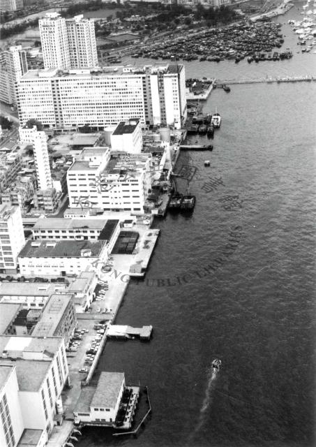
"There are Power Station, Government Store and Oil Depot along the coast. The Causeway Bay Typhoon Shelter and the Victoria Park can be seen at the back 1976."
The sign on the large building probably reads: Watson's Estate
Source: This image came from Flickr, see https://flickr.com/photo.gne?id=5019826296
Date picture taken
1976
Gallery
Shows place(s)

Comments
Part of North Point
More Fortress Hill than North Point, if we are allowed to use informal (MTR-influenced) area names.
Re: HK Government Logistics Services
Hi Klaus,
At around the Hong Kong Library watermark, where the "Hong Kong" phrase located should be the Hong Kong Governmetn Logistics Services Depot. The Depot cornered on Oil Street up to the sea front. I remember there used to be a public Morgue on Oil Street. Unable to confirm if it could be seen in the photo.
There are boundary walls on oil street, as well as on the eastern end of the depot, visible in the photo. The main gate of Logistics Services is approximately opposite 'King Wah Street', which is also visible.
On the other hand, on extreme zoom, you should be able to have a glimsp of a corner of the demolished Causeway Bay Police Station, just opposite the other end of Watson's Building on Electric Road.
T
Re: Bay View Police Station
Hi Thomas,
thank you for the additional details. The Government Logistic Services Depot also appears on the 1952 map on Gwulo, but I do not know anything about it.
The police station is partly visible (as you said). This should be a second generation building, the first one was likely demolished during WW2. In the Annual Report for the year 1948 it is referred:
A sum of approximately $6,500,000 is also being made available from Loan funds for the completion of the Divisional Headquarters at Kowloon City, for Police Stations at Bay View, Hung Hom and Shaukiwan, and for Police blockhouses in the New Territories. It did not prove possible to carry out very much of this work during the present year, but the work will be pushed forward during 1949-50.
Regards, Klaus