Current condition
Ruin
These are described on the government website describing local monuments:
During the Japanese Occupation Period [when the compound was used as a base for the Japanese Navy], extensive underground tunnels were constructed beneath the lawn but after World War II, in view of public safety, these tunnels were blocked and the lawn was re-turfed.
The tunnels were destroyed during the recent development works to turn the compound into a hotel & shopping mall.
If you have any memories of those tunnels, we'd love to hear from you.
MrB
Photos that show this Place
1945
Comments
Former Marine Police HQ Japanese Wartime Tunnels
Iain Ward's 'Sui Geng' printed in 1991 mentions that only one of the air raid tunnels remains 'today', used as store-room by the Welfare Handicrafts shop on Salisbury Road.
re: Former Marine Police HQ Japanese Wartime Tunnels
Thanks Moddsey, I didn't know any had survived as long as that. I had heard the old entrances were still visible in the old retaining wall that used to run along Canton Road. Unfortunately by the time I heard that it was too late to go and look for them.
re: Former Marine Police HQ
We've been sent this photo & comments, showing how thoroughly the area has been cleared - check out the trees suspended in mid-air, waiting for the ground level to be built back up again.
Here's another view of the area in the 1930s:
tunnel vision
hi this document prepared to future tenders has details on the tunnels - plus a confusing map of them... there was a plan to incorporate them into possible redevelopment, and even use them to enter the site. But was probably all to complicated.
http://www.pland.gov.hk/p_study/comp_s/mp_hq/final_report_pdf/MarinePolice_FR_2.pdf
here's an excerpt about the tunnels:
The preliminary study by Geotechnical Engineering Office (GEO) in
1990 recommended that the extent and quality of the backfilling of the
tunnel network beneath the platform should be determined and the
conditions of any accessible lengths of tunnels examined.
2.7.4. Two portals along Canton Road were inspected (Figure 2.6). The
southern portal (Portal A) is located below the Signal Tower and the
northern portal (Portal B) is situated at about 40m north of the southern
portal. Both portals have been brick-blocked, rendering the disused
tunnels inaccessible for inspection. The portals are about 2m in
diameter and are possibly entrances to 2 disused tunnels running eastwesterly
separated at 40m apart. As the rockhead level across the Site
is, in general, below street level, the disused tunnels, with their portals at
street level, were probably excavated in decomposed rock stratum.
2.7.5. Another study by GEO in 1994 recorded some ground investigation
works, and horizontal coreholes were attempted through Portals A and
B. However, it was found that Portal A was only a single layer of brick
wall and that the coring machine could not be mounted onto it. Fill
material was noted behind Portal A through direct visual inspection.
Corehole was drilled through Portal B. It was found that the
wall/bricked-up portal was some 2.9m thick and a layer of fill existed
behind the wall. It was thus believed that the tunnel network, at least for
these two tunnel sections, had been backfilled. No records of the
disused tunnels with regard to the extent and construction details could
be traced. There is also no record of any underground chamber or
disused tunnel network underneath the Main Building in the northern
part of the Site.
2.7.6. Further study by GEO in 2000 (Report No. PGA 5/2000) has identified
the possible presence of maintenance accesses, sunken water tank and
disused tunnels beneath the Main Building. A third tunnel portal (Portal
C) was identified on the southern slope in the Site facing the former Fire
Station. These portals are rather consistent to the results of the land
gravity survey.
....
The Site is also underlain by a network of disused tunnels. Any new
geotechnical works should assess the effects on and created by the
presence of the tunnels. It should be noted that to restore the tunnels to a
safely useable level, substantial engineering works may be required,
which may affect the historical appearance of the tunnels.
interestingly - the
interestingly - the antiquties and advisory board held a meeting on the tunnels.
Initial consultation with the Antiquities Advisory Board (AAB) on the
development options was conducted. The AAB was of the view that the
integrity of the monument should be preserved and additional structures on
the site platform were not preferred. As for the underground tunnels,
members generally agree in principle to their demolition though a certain
typical portion should be kept as a historical record. Notwithstanding, the
future developers must make every possible effort to conduct photographic
and cartographic recording of the tunnels and to salvage historic
construction materials of the tunnels as far as possible.
here's the link to the full report
re: tunnel vision
Thanks for the extra info.
The map on page 4 of the first document you linked to clarifies one of the earlier comments. It shows the location and photos of the 'welfare handicrafts shop' and the 'former fire station and quarters'.
MrB
Former Marine Police HQ
for anyone wishing to see the place on celluloid, Jackie Chan used it as a location for "Project A" back in 1983/4 where it was the, funnily enough, marine police/coastguard HQ.
re: Former Marine Police HQ
Some more comments and photos have arrived by email:
a 'typical portion' of tunnel
In 80skid's message above, he quotes the AAB : "As for the underground tunnels, members generally agree in principle to their demolition though a certain typical portion should be kept as a historical record."
That explains the small section visible on Canton Road near Salisbury Road:
Japanese Tunnels under Old Marine olice HQ
Most of them are still there. There is an entrance near the corner of Canton Road and Salisbury Road.
re: Japanese Tunnels under Old Marine Police HQ
Guy, please do you have any more information about the remaining tunnels? I thought that apart from the short section in the photo above (by the corner of Canton & Salisbury Road, as you describe) they were all destroyed during the excavation of the hill for the '1881 Heritage' project.
It will be good to find that some survived.
Regards, David
re: Japanese Tunnels under Old Marine Police HQ
1920s Canton Road
Nice scene of Canton Road looking towards the former TST KCR Station with Kowloon Godowns on the right. According to the study by the Geotechnical Engineering Office, Portals A and B are/were located at street level below the ramp roads leading up to the Marine Police HQ. Note that the northern ramp road became disused after WWII.
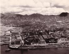
1945 Aerial View of Kowloon showing the existence of the ramp roads to/from Marine Police HQ.
http://gwulo.com/node/4085
North / South ramps
Nice shot - I didn't know there used to be two slopes here.
1910 Marine Police Station
In addition to showing the inauguration of the British Section of the KCR line in 1910, this long shot photo:
http://www.kcrc.com/en/about/popup_photo4.html
also shows the lush and tree-covered hill of the Marine Police HQ. Round House (without the timeball) can be seen above the southern slope. There is a path leading down the eastern slope towards today's Kowloon Park Drive. Note the general barrenness of the area with only the godowns belonging to the Kowloon Wharf and Godown Company visible. Middle Road is in the foreground with Nathan Rd in the centre.
A similar scene of the area can be seen here: http://gwulo.com/node/1993
The TST Post Office, near the site of the Fire Station, can also been seen in the photo and here: http://gwulo.com/node/1990
Re: Japanese Wartime Tunnels
A map of Portals A, B and C can be viewed at: https://www.pland.gov.hk/pland_en/p_study/comp_s/mp_hq/final_report_pdf/MarinePolice_FR_2_f2_6.pdf and the whole document here