I believe so as the Lands Office should have such records unless they are lost during the war years. You likely have to pay up for such records if they exist, like what you would do checking on the existing deeds before buying a flat in the second hand property market.
I don't know the details of how the enquiry works, however.
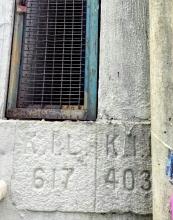
The 1896 map on Gwulo gives the lot number as KIL 617. This lot included a larger area than the present Rosary Church. The Rosary website refers that already in 1901 a small predecessor of the current church was built on the Canossian missionary premises. It might be possible that the lot was split later and Rosary had its own lot.
Maybe an interesting story, but unfortunately, it doesn't reveal the full number.
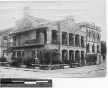
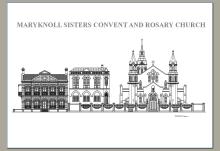
The lot number in the photo should be KIL4030. The Rosary Church site was part of St Mary's School (currently St Mary's Canossian College) site in 1900. The site was originally Kowloon Garden Lot 38 in the 1870s & 1880s, but was converted to KIL617 in 1890. The School and the Church shared the same lot number until the 1930s when Rosary Church was given a separate lot number KIL4030. The lot number was further changed to KIL9350 in 1964.
Rosary Church adjoins St Mary's on both its northern and western sides, so the boundary walls at the eastern end (facing Chatham Road) and the southern end (facing the alley adjacent to the Kimberley Road cul-de-sac) have the lot boundary stones. The stone(s) facing Chatham Road may have been damaged due to renovation works over the past decades, but the stones facing the alley should still be there.
My picture of the stone was taken at Chatham Road. Went to check the cul-de-sac the other day for those two stones in your photo without success. I went in the lane off the gate of the school as shown in the link below
The two lot boundary stones are still there. That part of the wall is covered with graffiti, but the stones are left intact. The picture below was taken today. The alley's entrance is right outside the gate of St Mary's.
So those two are between Kimberly Road (the vehicle entrence) and Austin Road in the west instead of between Kimberly Road and Chatham Road towards to east? Kindly confirm.
They are located at the alley between Kimberley Road and Chatham Road. See the map below. The red arrow is the location of the "damaged" lot boundary stones at Chatham Road i.e. the photo at the very beginning of this thread. The blue arrow is the location of the two stones that are at the alley.
Ah....that is the purpose of the alley -- a scavenging lane!! According to the Buildings Department, "......Historically, they (these lanes) provided the means of removing waste from dwellings, but in effect also acted as essential fire-breaks......"
Congrats! Yes, that lot boundary stone KIL617 shows the boundary of the first site which the Canossian sisters bought in 1886. The school campus was subsequently extended to the western part (currently the primary school) in the 1950s.
The change of lot number was necessary as the old KIL 4030 was split (in 1964 as ashchoi pointed out) into KIL 9350 and KIL 10553.
On KIL 9350 (125-127 Chatham Road) are Rosary Church and Catholic Centre, on KIL 10553 (121-123 Chatham Road) is Winston Mansion (date of first occupation 9/1963).
Comments
Re: KIL Marker
Hi Lo,
That likely means, the marker was for a previous lease and already expired.
T
Thanks. Is there any way to
Thanks. Is there any way to check the previous lot number?
Re: Checking expired lot information
Hi Lo,
I believe so as the Lands Office should have such records unless they are lost during the war years. You likely have to pay up for such records if they exist, like what you would do checking on the existing deeds before buying a flat in the second hand property market.
I don't know the details of how the enquiry works, however.
T
K.I.L. ?
The 1896 map on Gwulo gives the lot number as KIL 617. This lot included a larger area than the present Rosary Church. The Rosary website refers that already in 1901 a small predecessor of the current church was built on the Canossian missionary premises. It might be possible that the lot was split later and Rosary had its own lot.
Maybe an interesting story, but unfortunately, it doesn't reveal the full number.
KIL 4030
See these notes from ashchoi:
The lot number in the photo should be KIL4030. The Rosary Church site was part of St Mary's School (currently St Mary's Canossian College) site in 1900. The site was originally Kowloon Garden Lot 38 in the 1870s & 1880s, but was converted to KIL617 in 1890. The School and the Church shared the same lot number until the 1930s when Rosary Church was given a separate lot number KIL4030. The lot number was further changed to KIL9350 in 1964.
Millions thanks for
Millions thanks for forwarding such great details.
Here is a photo taken in 2018
Here is a photo taken in 2018 showing both lot numbers KIL617 and KIL4030.
Which street do they face?
Which street do they face? Perhaps I can go there to check their present status.
KIL4030
Rosary Church adjoins St Mary's on both its northern and western sides, so the boundary walls at the eastern end (facing Chatham Road) and the southern end (facing the alley adjacent to the Kimberley Road cul-de-sac) have the lot boundary stones. The stone(s) facing Chatham Road may have been damaged due to renovation works over the past decades, but the stones facing the alley should still be there.
My picture of the stone was
My picture of the stone was taken at Chatham Road. Went to check the cul-de-sac the other day for those two stones in your photo without success. I went in the lane off the gate of the school as shown in the link below
92 金巴利道
https://maps.app.goo.gl/FbauMb4EsGcx1xLP9
... exit from here
2 柯士甸路
https://maps.app.goo.gl/NStAGRRnuu1bDxjR8
Hi,
Hi,
The two lot boundary stones are still there. That part of the wall is covered with graffiti, but the stones are left intact. The picture below was taken today. The alley's entrance is right outside the gate of St Mary's.
Re: Location of the stones
Hi There,
So those two are between Kimberly Road (the vehicle entrence) and Austin Road in the west instead of between Kimberly Road and Chatham Road towards to east? Kindly confirm.
T
I did enter the lane from
I did enter the lane from next to the gate of the school, then come across quite some graffiti, turned right to exit next to a bar.
Are those stones near the gate or the bar, or the turn? At eye level or near the ground?
There were some items here and there which might have blocked my view.
Location of the lot boundary stones
They are located at the alley between Kimberley Road and Chatham Road. See the map below. The red arrow is the location of the "damaged" lot boundary stones at Chatham Road i.e. the photo at the very beginning of this thread. The blue arrow is the location of the two stones that are at the alley.
Alas, that place was stacked
Alas, that place was stacked with garbages with a cleaning lady sat in front of them ... have to visit again.
Location of the lot boundary stones
Ah....that is the purpose of the alley -- a scavenging lane!! According to the Buildings Department, "......Historically, they (these lanes) provided the means of removing waste from dwellings, but in effect also acted as essential fire-breaks......"
Finally found them just
Finally found them just before the cleaning lady was going to block them up with garbage again.
K. I. L. 617
If one is interested, the captioned lot marker also appears here around the corner at Austin Road.
KIL 617
Congrats! Yes, that lot boundary stone KIL617 shows the boundary of the first site which the Canossian sisters bought in 1886. The school campus was subsequently extended to the western part (currently the primary school) in the 1950s.
AC
More details on KIL 4030
The change of lot number was necessary as the old KIL 4030 was split (in 1964 as ashchoi pointed out) into KIL 9350 and KIL 10553.
On KIL 9350 (125-127 Chatham Road) are Rosary Church and Catholic Centre, on KIL 10553 (121-123 Chatham Road) is Winston Mansion (date of first occupation 9/1963).