Current condition
In use
Date completed
See the story behind at The Anglo Chinese Boundary 1898
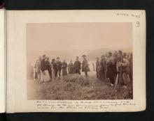
Mr. Stewart Lockhart's report:
The Northern Boundary commences at the point of high water-mark in Mirs Bay where the meridian of 114°.30' East cuts the land and follows that high water-mark to the point marked with a peg immediately to the West of the market town locally known as Tung Wo Hü and sometimes called Shat'aukok.
Marker set in the morning of the 17th March, 1899.
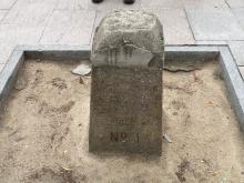
The wooden marker (peg) surely was replaced by a boundary stone. Current status unknown. Update 2021-07-02: still exists, see photo below.
Photos that show this Place
1899
2014
Comments
Update 2021-07-02
The original wooden marker was replaced by a "permanent boundary stone of a substantial character" in 1905. (Source)
The boundary stone is marked
The boundary stone is marked on the 1952 map: https://gwulo.com/node/55185?a=1#17/22.54400/114.22811/Map_by_ESRI-1952…