This website gives informations about the boundary stones and attempts to declare these as " statutory monuments ". The article is in Chinese, I can only use GoogleTranslator to understand the content (obviously not always correct translated).
The translation of the title is
Visually presents the historical record of the "Sites" and the scholars call for the boundary pillar to be a statutory monument.
In this article the following is referred:
There are 20 boundary pillars on land in the north-east of the New Territories, of which 'China-UK Street' is erected at Nos. 1 to 8 and the remaining 12 boundary pillars are in the northwest of Present-day Sino-British Street,....
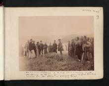
11. New Territory.—Matters in the New Territory have absorbed a large part of the time of the Survey staff during the year. It was considered desirable to define the Anglo-Chinese Boundary between Sha Tau Kok and Lin Ma Hang and this was done, permanent boundary stones of a substantial character being established and surveyed.Certain areas of padi land which had been omitted in the original Survey were picked up and mapped and all the quarries between Kowloon City and Lyemun Pass were surveyed and marked with boundary stones.
The prints of Mr. NEWLAND'S 2" map were received from England and have proved most useful.
That's the (translated) German title of the US movie "Short Circuit".
No. 5 Boundary Stone (Replica), by ButchokoyD
So far, I couldn't find a photo of the boundary stone No. 5. This photo seemed to be the solution of the problem as the stone could have been removed from Sha Tau Kok and exhibited at the Hong Kong Museum of History in Tsim Sha Tsui.
But -
Obviously, it's a replica - and not an exact one!
It bears the date 1899; this is ok with the year of delimitation of the boundary, but the original shows the date 1898 - that's the year of the Second Peking Convention.
On the Mainland side of the border at Sha Tau Kok, is the Zhong-Ying Street Historical Museum. It is worth a visit if one is looking for information on the boundary stones along Chung Ying Street.
Regarding No. 5 Boundary Stone, one of my photos from 2005, shows only the top half of a boundary stone that is visible whilst the bottom half is embedded into the ground. See here Perhaps the elusive No. 5 as I had noted down Nos. 3 and 4 along the Street.
Hi Moddsey, I've read about the museum - probably an interesting place to visit. However, it seems almost impossible to get here as it is located inside an area with restricted access. Tourist guides say it's easier to go there from the Chinese side.
Regarding the boundary stones, I've found interesting details in the Chinese version of Zhong-Ying Street on Wikipedia. Possibly "your" stone is No. 7, but they are not sure about the number. I will post this very soon.
The following is a Google translation of the Chinese version (without guarantee for correct translation):
History
In 1898, the United Kingdom and the Qing Government signed a treaty about the lease the New Territories. The survey for the delimitation of the Sino-British boundary began here on 16 March 1899 and ended on 18 March.
The highest water level of the ShaTauKok River at high tide is used as the dividing line to the east between the two countries. At least until 1922 it was still the mouth of the Sha Tau Kok River. However, due to the shallow riverbeds in the Sha Tau Kok area, by the time of the Second World War, they had completely dried up (the mouth of the Sha Tau Kok River was now completely in the Chinese mainland).
At that time, the Hong Kong Government did not restrict residents from travelling between Hong Kong and the Chinese mainland, so the riverbed became a natural street, with shops set up on both sides of the riverbed and renamed it Chung-Ying (Sino-British) Street , known as the "Shoal Road".
After 1949, socialism was practised in Chinese mainland, while Britain, as the patriarchy of Hong Kong, was a capitalist country , with the two camps hostile to each other . The Chung-Ying Street and the Shenzhen River on the Hong Kong-Shenzhen border became the front lines of the cold war confrontation between the two rival camps, described as the "Oriental Berlin Wall".
……
Chung-Ying Street BoundaryPillars
The Sino-British Street Boundary Monument consists of the eight Sino-British boundary markers placed in the middle of the Chung-Ying Street. In December 1941, Japan invaded and occupied Hong Kong and removed the boundary markers 3 to 7 of Chung-Ying Street in the name of obstructing traffic. After the victory of the Anti-Japanese War, in April 1948, both sides of Chung-Ying Street held a grand boundary monument erection ceremony at Sha Tau Kok. The British side decided to set up 20 stone monuments on the boundary of Sha Tau Kok as boundary markers. Among them, there are 8 boundary monuments in Sha Tau Kok Old Town and Chung-Ying Street.
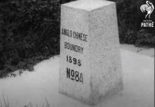
The Chinese and British Street Boundary Monument is engraved with the Chinese "光緒二十四年中英地界第x號” (Twenty-fourth year of Guangxu, China-British Land Boundary No. x) on the side facing Shenzhen; on the side facing Hong Kong is "ANGLO·CHINESE BOUNDARY 1898 No. x" in English.
The boundary pillars that can be seen on Chung-Ying Street are:
Boundary Monument No. 1: It is located near the Chung-Ying Street History Museum, behind the Jingshi Bell, and beside the inscription stone monument by Jiang Zemin. At present, it is completely in Shenzhen.
Boundary Marker No. 2: Located about 100 meters north of Boundary Marker No. 1, outside the fence of a residential area in the New Territories, it was inclined at a 20-degree angle with the ground due to inadvertent road construction. At present, it is completely in Shenzhen.
Boundary Marker No. 3: Located near the entrance to the New Territories of Hong Kong.
Boundary Monument No. 4: Located under the century-old banyan tree on Chung-Ying Street.
Boundary Monument No. 5: Located in the north section of Chung-Ying Street.
Boundary Monument No. 6: Located in the north section of Chung-Ying Street.
Boundary Marker No. 7: Located in the vicinity of the Marble Monument of the Guangdong Provincial Cultural Relics Protection Unit, which is located at the boundary marker of Chung-Ying Street, the lower half has been buried due to road construction.
According to a report published on Nanfang.com, Boundary Marker No. 8 shows that the boundary marker has "laid in the creek under the joint inspection bridge entering Chung-Ying Street." [more information on Gwulo here].
{C}Chung Ying Street Boundary Stones 1 - 8, by Klaus{C}
There is a short film from 2011 showing the boundary stones (1-7). Although they deliminate the boundary between Hong Kong and China, no one seems to care when crossing the boundary.
Comments
Boundary Stones
Photos of Boundary Stones on Chung Ying Street are on Wikimedia Commons here.
More on boundary stones
Source: 直觀呈現「界址專條」歷史紀錄 學者籲列界碑為法定古蹟
This website gives informations about the boundary stones and attempts to declare these as " statutory monuments ". The article is in Chinese, I can only use GoogleTranslator to understand the content (obviously not always correct translated).
The translation of the title is
Visually presents the historical record of the "Sites" and the scholars call for the boundary pillar to be a statutory monument.
In this article the following is referred:
There are 20 boundary pillars on land in the north-east of the New Territories, of which 'China-UK Street' is erected at Nos. 1 to 8 and the remaining 12 boundary pillars are in the northwest of Present-day Sino-British Street,....
Public Works Report for 1905
11. New Territory.—Matters in the New Territory have absorbed a large part of the time of the Survey staff during the year. It was considered desirable to define the Anglo-Chinese Boundary between Sha Tau Kok and Lin Ma Hang and this was done, permanent boundary stones of a substantial character being established and surveyed. Certain areas of padi land which had been omitted in the original Survey were picked up and mapped and all the quarries between Kowloon City and Lyemun Pass were surveyed and marked with boundary stones.
The prints of Mr. NEWLAND'S 2" map were received from England and have proved most useful.
Number Five - Still Alive?
That's the (translated) German title of the US movie "Short Circuit".
So far, I couldn't find a photo of the boundary stone No. 5. This photo seemed to be the solution of the problem as the stone could have been removed from Sha Tau Kok and exhibited at the Hong Kong Museum of History in Tsim Sha Tsui.
But -
Obviously, it's a replica - and not an exact one!
It bears the date 1899; this is ok with the year of delimitation of the boundary, but the original shows the date 1898 - that's the year of the Second Peking Convention.
So the search continues.
Zhong-Ying Street Historical Museum
On the Mainland side of the border at Sha Tau Kok, is the Zhong-Ying Street Historical Museum. It is worth a visit if one is looking for information on the boundary stones along Chung Ying Street.
Regarding No. 5 Boundary Stone, one of my photos from 2005, shows only the top half of a boundary stone that is visible whilst the bottom half is embedded into the ground. See here Perhaps the elusive No. 5 as I had noted down Nos. 3 and 4 along the Street.
Museum and Stone
Hi Moddsey, I've read about the museum - probably an interesting place to visit. However, it seems almost impossible to get here as it is located inside an area with restricted access. Tourist guides say it's easier to go there from the Chinese side.
Regarding the boundary stones, I've found interesting details in the Chinese version of Zhong-Ying Street on Wikipedia. Possibly "your" stone is No. 7, but they are not sure about the number. I will post this very soon.
Regards, Klaus
More about the stones from the Chinese Wikipedia article
There is an article on the Chinese Wikipedia
The following is a Google translation of the Chinese version (without guarantee for correct translation):
History
In 1898, the United Kingdom and the Qing Government signed a treaty about the lease the New Territories. The survey for the delimitation of the Sino-British boundary began here on 16 March 1899 and ended on 18 March.
The highest water level of the Sha Tau Kok River at high tide is used as the dividing line to the east between the two countries. At least until 1922 it was still the mouth of the Sha Tau Kok River. However, due to the shallow riverbeds in the Sha Tau Kok area, by the time of the Second World War, they had completely dried up (the mouth of the Sha Tau Kok River was now completely in the Chinese mainland).
At that time, the Hong Kong Government did not restrict residents from travelling between Hong Kong and the Chinese mainland, so the riverbed became a natural street, with shops set up on both sides of the riverbed and renamed it Chung-Ying (Sino-British) Street , known as the "Shoal Road".
After 1949, socialism was practised in Chinese mainland, while Britain, as the patriarchy of Hong Kong, was a capitalist country , with the two camps hostile to each other . The Chung-Ying Street and the Shenzhen River on the Hong Kong-Shenzhen border became the front lines of the cold war confrontation between the two rival camps, described as the "Oriental Berlin Wall".
……
Chung-Ying Street Boundary Pillars
The Sino-British Street Boundary Monument consists of the eight Sino-British boundary markers placed in the middle of the Chung-Ying Street. In December 1941, Japan invaded and occupied Hong Kong and removed the boundary markers 3 to 7 of Chung-Ying Street in the name of obstructing traffic. After the victory of the Anti-Japanese War, in April 1948, both sides of Chung-Ying Street held a grand boundary monument erection ceremony at Sha Tau Kok. The British side decided to set up 20 stone monuments on the boundary of Sha Tau Kok as boundary markers. Among them, there are 8 boundary monuments in Sha Tau Kok Old Town and Chung-Ying Street.
The Chinese and British Street Boundary Monument is engraved with the Chinese "光緒二十四年 中英地界 第x號” (Twenty-fourth year of Guangxu, China-British Land Boundary No. x) on the side facing Shenzhen; on the side facing Hong Kong is "ANGLO·CHINESE BOUNDARY 1898 No. x" in English.
The boundary pillars that can be seen on Chung-Ying Street are:
According to a report published on Nanfang.com, Boundary Marker No. 8 shows that the boundary marker has "laid in the creek under the joint inspection bridge entering Chung-Ying Street." [more information on Gwulo here].
Youtube film about the boundary stones
There is a short film from 2011 showing the boundary stones (1-7). Although they deliminate the boundary between Hong Kong and China, no one seems to care when crossing the boundary.
Thanks
Thanks for the video. Nice to see the stones.
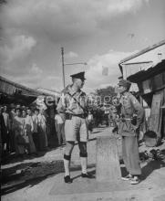
Anglo-Chinese Boundary Stone No. 3
From 1938, the Anglo- Chinese Boundary Stone No. 3 on Chung Ying Street, Shau Tau Kok (STK) and STK to Fanling mile marker: https://marcus.uib.no/instance/photograph/ubb-lkl-1-05-11.html