Guest author Klaus Liphard describes how the boundary between the New Territories and China was created in the 1890s.
Introduction
At the end of the 19th century, the Chinese Qing Empire was weak. This was utilized by foreign powers - France, Germany, Russia, and also Great Britain - to force China to lease territories to them.
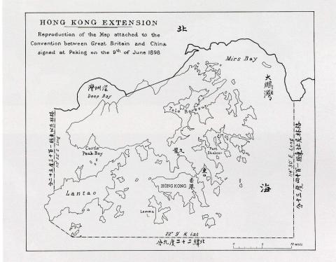
Britain forced China into The Convention Between Great Britain and China Respecting an Extension of Hong Kong Territory, also known as the Second Convention of Peking, which leased the New Territories to Britain for 99 years. The Convention was signed on 9 June 1898 in Peking (Beijing) and became effective on July 1st, 1898. This short convention (the English text is only one and a half pages) included a map showing the new boundary.
in 1898, by Klaus
This map had a small scale only. The eastern end of the boundary on land was at Starling Inlet (Mirs Bay), and the western one at Deep Bay. Between these two end points, a straight line was drawn. The exact course of the boundary had to be negotiated by a Sino-British commission and should follow approximately the course of the Sham Chun River (深圳河).
In addition to that, the waters of Mirs Bay west of 114’30” E longitude as well as the waters of Deep Bay east of 113°52’ E longitude would be British. The southern boundary would be at 22°9’ N latitude.
Views of the British side
Hong Kong’s Colonial Secretary James Stewart Lockhart was appointed Special Commissioner for the New Territory. He ordered surveys to be conducted and wrote several reports to the Governor Henry R. Blake. The governor himself reported to the Colonial Office [Secretary of State for the Colonies Joseph Chamberlain] in London for final decisions on how to proceed.
Although the convention was signed in 1898, it took some time to finalize the surveys – therefore the final commitment of the boundary between Hong Kong and China was made in early 1899.
The source of the following statements is the PAPERS RELATING TO THE EXTENSION OF THE COLONY OF HONGKONG [you may have to click twice on the link before you can see the document]
There was high interest of the British side to push the boundary beyond the Sham Chun River to the next mountain range to include the whole valley to Hong Kong territory (including the town Sham Chun/Shenzhen).
|
Report by Mr. Stewart Lockhart on the Extension of the Colony of Hongkong; October 8, 1898. [……..] BOUNDARY LINE. The boundary line indicated on the map attached to the Convention (Map I.) is the shortest line from sea to sea that could be found, measuring on the map only eleven (11) miles. Following the river from Deep Bay to Sham Chun and the road from the latter place to Starling Inlet, the actual distance is about thirteen (13) miles. This boundary line is open to great objection. It cuts in two the rich valley of which Sham Chun is the centre, and, while excluding that town, divides the villages in the valley hitherto linked together by family ties and common interests, and at present separated, so far as the river extends, by about 100 feet of a tidal river, and onwards from Sham Chun to Starling Inlet by no boundary whatever. All these villages regard Sham Chun as their central and most important market, where they dispose of their goods and make their purchases, and much difficulty and friction would be certain to arise if the villages on one side of the stream or road come under British jurisdiction whilst those on the other remain under Chinese rule. 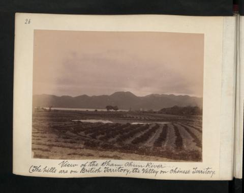
by The National Archives UK
Another important reason why Sham Chun should not be excluded from the area to be leased is that it is the seat of the Head Council of the local as opposed to the Imperial Government, represented by the district magistrate, who resides at Namt‘au. This Head Council controls all the village and other tribunals through-out the Tung Ló or Eastern Division of the San On district, which is that portion of the district included in the Convention, and exercises great influence in every village. Again, it must be remembered that the chief industry of the villages in the valleys is the cultivation of rice, for which an ample and constant supply of water is necessary. If the boundary line indicated on the Convention map be followed, endless dispute as to water rights between villages under British and Chinese jurisdiction are certain to ensue; dissatisfaction will be created; and the task of government will be rendered more difficult. The proposed boundary would also render smuggling an easy matter, which, in view of the pledge given to China, ought to be avoided. The disadvantages of having a Chinese town just outside British territory have been experienced in the case of Kowloon, which for years has been a source of never-ceasing trouble and constant friction between the Governments of Hongkong and China. History will certainly repeat itself if Sham Chun be allowed to remain in Chinese territory. In the opinion of all those acquainted with the country, whether belonging to the naval, military, or civil services, it is essential, in the interests of good government, and in order to maintain friendly relations with China, that the town of Sham Chun should be included in the lease. The boundary between two countries, which leads to least friction, is either a broad and deep river or the ridges of hills forming the watersheds of different valleys. In the San On district there is no broad river such as would form a suitable boundary. But there are ridges of hills which could be utilised for that purpose. This proposed line, which includes the important town of Sham Chun and the land to the north and east of Mirs Bay and to the west of Deep Bay, forms a good, natural boundary, running along the crest of the hills, is easy of defence, and would help to check smuggling. It renders unnecessary the separation of villages hitherto united, removes all danger of disputes about water rights, and obviates any interference with the present system of local self-government, on the support of which the success of British administration in the new territory must to a great extent depend. |
Views of the Chinese side
I have not read any documents that give a clear idea of the Chinese viewpoint, but it is safe to assume that China was not willing to cede more than absolutely necessary.
On the Chinese side Wong Ts’ün-Shin (=transcription of the name from the reports, in Chinese characters: 王存善), a representative of the Viceroy at Canton, was responsible for the negotiations regarding the boundary for China.
Governor Blake wrote this letter to the Secretary of State on 17th March, 1899.
|
TO: The Right Honourable JOSEPH CHAMBERLAIN, M.P. SIR, 1. I have the honour to inform you that Mr. WONG TS`ÜN-SHIN, who was deputed by the Viceroy of Canton to assist in the delimitation of the northern boundary of the Kowloon extension, arrived on the 10th instant, and on the 11th had an interview with Mr. STEWART LOCKHART. He returned to Canton on the 12th instant to consult the Viceroy and came back on the 14th instant when he again met Mr. STEWART LOCKHART with a proposal that the Sham Chun river should form the boundary. This was the extreme limit to which he was permitted to go. |
Dramatis Personae
The Government Officials
The representative of the British Crown was Sir Henry Arthur Blake. He was the Governor of Hong Kong from 25 November 1898 to 21 November 1903.
The representative of the Chinese Empire was the “Viceroy of Canton” as referred in the British reports – his name is not mentioned there (for whatever reason?). Wikipedia gives the correct title as Viceroy of Liangguang (full title: Governor-General, Commander and Quartermaster, Supervisor of Waterways, and Inspector-General of the Two Expanses and Surrounding Areas). His name was Tan Zhonglin (Chinese: 譚鍾麟; Wade–Giles: T'an Chung-lin, he was viceroy from 16 April 1895 to 19 December 1899.
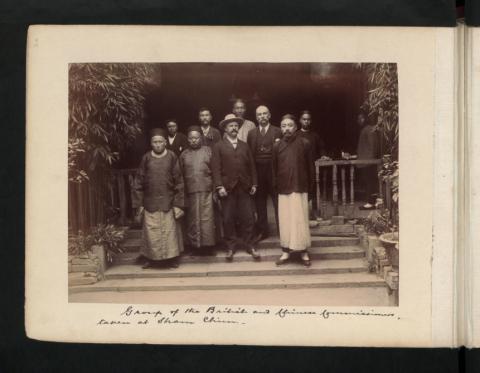
There is a photo of both, probably taken during the visit of Governor Blake in Canton on the 2 April 1899.

The Negotiators
There is a photo of the British and Chinese Delegation showing WONG TS’ÜN-SHIN (王存善) on the right and JAMES HALDANE STEWART LOCKHART second from right in the front row.
by The National Archives UK
Names of the other persons are not known, though the European standing between Lockhart and Wong is likely Mr. ROBERT DALY ORMSBY, Director of Public Works, who also participated the delimitation.
Further Negotiations
The letter continues:
|
2. He came here with Mr. STEWART LOCKHART and we discussed the matter for over two hours. I endeavoured to show him that it would be to the mutual advantage of China and this Government to have Sham Chun and Shat'aukok included in the leased territory, and pointed out to him that, if they were, they would still be open for the Chinese to as great an extent as at present, while if they are not ceded they will be closed to the Chinese inhabitants of this Colony who have been in the habit of resorting to them ; but it was clear that he had orders not to grant them. I then thought it well to have the river boundary formally agreed to as a provisional measure, leaving our pressing demand for the boundary of the base of the hills to the North open for further consideration at Peking. I wrote an agreement [Enclosure No.1] which was signed by the Chinese Commissioner and Mr. STEWART LOCKHART. I have explained the situation fully to Sir CLAUDE MACDONALD [Her Majesty's Minister in China since 1896 and the British negotiator for the Second Convention of Peking] and sent him a copy of the map of which I enclose a copy [map not available], being the only good survey of the boundary district that has yet been made. The provisional boundary is marked in red, the proposed boundary in blue. I have no doubt that it would be a great convenience to this Colony to have the two towns named included. But pending the further negotiations on the point the fixing of the boundary to the river will enable me to take over the territory which I shall do as soon as the necessary preparations are complete for having a police force and a magistrate there. I shall inform you by telegraph when I can fix the date. […..] 5. I enclose for your information copy of a letter addressed to me by Mr. STEWART LOCKHART and of its enclosures relative to the progress of his negotiations with the delimitation Commissioner appointed by the Chinese Government. I have the honour to be, Sir, Your most obedient, humble Servant, HENRY A. BLAKE, Governor, &c. |
|
ENCLOSURE No. 1. (Agreement referred to in the Governor's despatch of 17th March, 1899.) It is agreed that for the present the river past Sham Chun to Shat'aukok shall be the boundary to its source North-West of Shat'aukok and thence to Mirs Bay immediately to the West of Shat'aukok; the North bank of the river referred to being the boundary. The question of including Sham Chun and Shat'aukok is to remain open for further reference to Peking. J. H. STEWART LOCKHART. 王存善 i.e., WONG TS’ÜN-SHIN. 14th March, 1899. |
|
(Governor to Mr. Stewart Lockhart.) The Honourable J. H. STEWART LOCKHART, C.M.G., &c. GOVERNMENT HOUSE, HONGKONG, 11th March, 1899. I hereby appoint you, under authority from the Secretary of State for the Colonies, to be the representative of the Government of Great Britain for the purpose of fixing the exact boundaries of the extension of Hongkong in accordance with the terms of the Convention signed at Peking on the 9th June, 1898. I have the honour to be, Sir, Your most obedient Servant, HENRY A. BLAKE, Governor, &.c. |
|
ENCLOSURE No. 2. (Mr. Stewart Lockhart to Governor.) COLONIAL SECRETARY'S OFFICE, HONGKONG, 16th March, 1899. SIR, I have the honour to acknowledge the receipt of the instrument signed by Your Excellency dated the 11th instant, appointing me, under instructions from the Secretary of State for the Colonies, the representative of Great Britain for fixing the boundaries of the extension of the Colony of Hongkong. 2. Acting under that instrument I have held two interviews with the Commissioner appointed by the Government of China for the delimitation of the frontier of the extension of the Colony of Hongkong. 3. I am glad to be able to state that after considerable difficulty I have induced the Commissioner for China to agree to the North bank of the Sham Chun river to its source as the boundary between British and Chinese territory. It is gratifying to me to have succeeded in securing in the new extension complete control of that river, which on the map attached to the Convention is not included within the territory leased to Great Britain. It is scarcely necessary to point out that without such complete control the development of the territory would have been rendered very difficult. 4. In my report to the Colonial Office of the 8th October last, I strongly recommended that the town of Sham Chun should he included in the leased territory, and I stated at some length the reasons for my recommendation. I enclose a copy of that portion of my report dealing with this matter. Nothing has occurred since that report was written to modify in any way my views on this subject, and I trust that in the interest of Great Britain the British Minister at Peking will be able by diplomatic representations to secure that not only the town of Sham Chun but also the town of Shat'aukok will be included within the British boundary. 5. I am about to proceed today to delimit with the Chinese Commissioner the boundary agreed upon between us, which is described in the Agreement signed before Your Excellency at Government House on the 14th instant, a copy of which is enclosed. I will in due course report the result of our mission. I have the honour to be, Sir, Your most obedient Servant, J. H. STEWART LOCKHART, Colonial Secretary |
Final Agreement
Governor Blake summarized the outcome of negotiations in a letter to the Secretary of State (“The Right Honourable JOSEPH CHAMBERLAIN, M.P.”) on the 24th March, 1899. Attached were:
|
ENCLOSURE NO. 1. (Mr. Stewart Lockhart to Governor.) No. 16. COLONIAL SECRETARY'S OFFICE, HONGKONG, 20th March, 1899. SIR, 1. I have the honour to report that, accompanied by Mr. ORMSBY, Director of Public Works, I left for Mirs Bay on Thursday last, the 16th, to delimit the boundary of the new territory leased to Great Britain by China. 2. I was met on the morning of the 17th instant at Starling Inlet by the Officer deputed by the Chinese Government to carry out the work of delimitation on behalf of China. 3. The delimitation was completed on the 18th instant on which day I returned to Hongkong. On the 19th instant, I met the Officer deputed by the Chinese Government and we both signed the enclosed memorandum which clearly defines the boundaries of the new territory. 4. I attach a sketch map on which the boundary defined in the memorandum referred to above is indicated. This map has been prepared by Mr. ORMSBY, Director of Public Works, who has been of great assistance to me in settling a satisfactory boundary. 5. I had a final interview with Mr. WONG, the Chinese representative, to-day. I have the honour to be, Sir, Your Excellency's most obedient Servant, J. H. STEWART LOCKHART, Colonial Secretary. |
The source of the map below is unknown, probably not the one addressed in the statement above. However, it could be similar to that as there were no detailed maps of this area available in 1899.

Delimitation of the Boundary
|
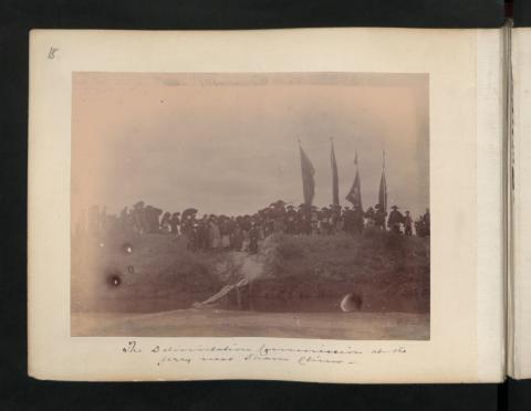
His Excellency SIR HENRY A. BLAKE, G.C.M.G., Governor of Hongkong. MEMORANDUM (Referred to in Mr. Stewart Lockhart's Letter of the 20th March, 1899.) The Northern Boundary commences at the point of high water-mark in Mirs Bay where the meridian of 114°.30' East cuts the land and follows that high water-mark to the point marked with a peg immediately to the West of the market town locally known as Tung Wo Hü and sometimes called Shat'aukok. [see First marker of the The Anglo Chinese Boundary 1898 [1899- ]] 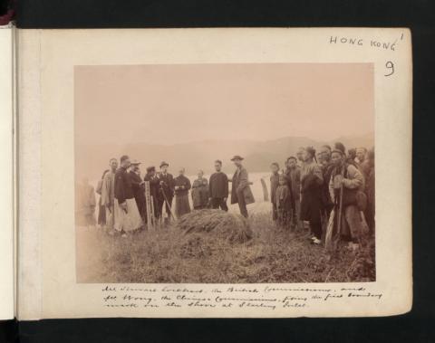
fixing the first boundary mark in the shore at Starling Inlet., by The National Archives UK
It then proceeds straight inland for a short distance till it meets a narrow path between fields on the right and a tidal flat on the left. A peg was driven in to the East of the path, and it was agreed that the whole of the path is within British territory but may be used by the inhabitants of both countries. The line follows this path until it reaches a corner of the market town of Tung Wo Hü where another peg was driven in and then proceeds until it comes to the bed of a wide stream which is at present dry. It was agreed that the boundary should follow the centre of this river bed. The land to the right of the river, that is, the land on the left bank being within Chinese territory; the land to the left of the river, that is, the land on the right bank being within British territory. |
Interlude 1
This stream likely wasn’t dry forever. Probably the boundary stone No. 8 that was placed there later was washed away by floods. In April 1948, two new stones No’s 8A (Hong Kong side) and 8B (China side) were placed on opposite shores of the river instead.
")
|
This line along the middle of the river's bed continues until a road leading to the village Rang Han is reached. A peg was driven in at the point where the boundary line leaves the river and follow’s this road. It was agreed that the whole of the road is within British territory but may be used by the inhabitants of both countries. This road leads up a steep ravine crossing and re-crossing the stream. It was agreed that the waters of this stream whether within the British or the Chinese boundary should be available for the inhabitants of both countries. This road passes through a gap about 500 feet above sea level forming the dividing ridge between the Shat'aukok and Sham Chun valleys. The boundary was marked at this point with a peg. 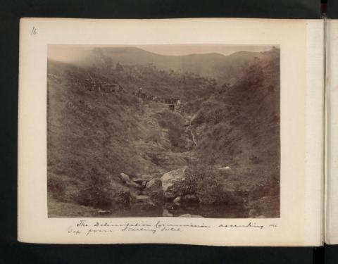
It was agreed that the road from this gap should be the boundary and is within British territory but may be used by the inhabitants of both countries. This road passes down the right-hand side of the ravine and has a stream on the left running to Kang T'o’. At the foot of the ravine this road crosses a larger stream coming from the direction of Ng Tung Shán and re-crosses it within a distance of 100 yards. This road passes Kang T'o’ village on the right and reaches the Sham Chun river at a distance of about a quarter of a mile below Kang T`o’. 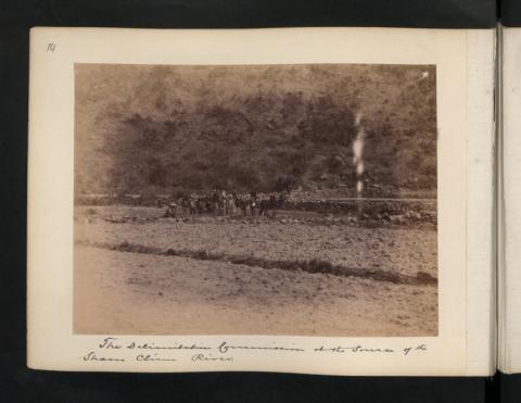
It was agreed that up to this point this road is within British territory but may be used by the inhabitants of both countries. It was also agreed that the waters of the stream running from Ng Tung Shan referred to above should be available for cultivators of land in both territories. A peg was driven in to mark the point where this road as a boundary ended. |
Interlude 2
The delimitation took two days. During the night in between, the commissioner and his staff lodged in this house at Sham Chun. This photo of Lockhart and Wong was also taken there.
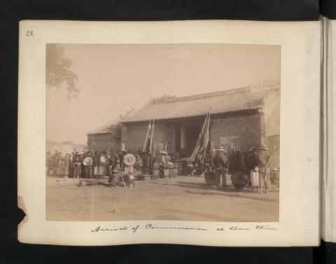
To get there, they probably used the Lo Wu Ferry.
|
The boundary then follows the right or northern bank of the river generally known as the Sham Chun river down to Deep Bay, all the river and the land to the south being within British territory. The Western, Eastern, and Southern boundaries are as laid down in the Convention, the whole of the Island of Lantao being within British territory. The waters of Mirs Bay and Deep Bay are included in the area leased to Great Britain. Signed in the Council Chamber, Hongkong, this 19th day of March, 1899. J. H. STEWART LOCKHART. 王存善, i.e., WONG TS‘ÜN-SHIN. In the presence of TSOI YEUK-SHAN. KI WAI |
Further Reading
- Further reading about the development of the boundary until today: Hong Kong, China: The Border as Palimpsest; Written On 8 February 2021. Author: Denise Y. Ho (Online copy available here)
- Boundary Stones along Chung-Ying Street
- More photos on Wikimedia Commons and Flickr (start clicking from this entry).
Klaus, writing from his home in Germany, has been interested in Hong Kong and its history for many years. He first visited Hong Kong in 1980, and has made several more visits since then. Klaus is a regular contributor to Gwulo - click here to see more of his posts.
Good Read
Have always been interested in reading about the Anglo-Chinese Boundary Stones. Made a trip in 2005 to view the boundary stones at Sha Tau Kok along Chung Ying Street. The book "Unequal Treaty 1898-1997: China, Great Britain, and Hong Kong's New Territories " (Hong Kong: Oxford University Press, 1998) got me going.
First marker
Thank you, moddsey. A question regarding the the first marker. There are photos of the boundary stones along Chung Ying Street. Have you ever heard of the one near the shore?
Re: First Marker
One can read about the Anglo-Chinese Boundary: https://oelawhk.lib.hku.hk/items/show/1018
New Territories boundary
Good to see a careful account of the land border between Hong Kong and China. At first glance, however, it doesn't seem to add anything to my own description in Unequal Treaty.
Thank you for providing an
Thank you for providing an interesting insight into the origins of the 1898 Convention. I have always wondered why it was not given in Perpetuity (my personal preference!) and why it was limited to just 99 years. A reading of the article makes it clear that the 99 year lease was only agreed to by the Chinese because they had little choice - it was not lack of interest in Hong Kong/ New Territories. This is something I have always wondered as I had assumed that HK and NT were probably in 1898, not considered of great worth to the Chinese, despite the opium trade.
It also answered my question as to why the British did not obtain a lease of a much larger area - the documents make it plain that the Chinese were digging their heels in and the British had difficulty even nailing down the boundary eventually agreed upon. Seeing the original documents provided a fascinating read - much appreciated, a most interesting post.
NT Boundary
Peter ws -I havn't read your article - must look it up.
Re: Unequal Treaty
Hi Peter,
unfortunately, I do not know your book. I'm sure it reveals many more details and background information compared to my post. The intention was to use as many orginal references from 1899 as possible, illustrated with photos from the UK National Archives.
Regards, Klaus
Klaus, the book was
Klaus, the book was originally my PhD thesis yet was a bit of a bestseller at the time (I think 1979). Glad it was the revised edition of 1998 which was referred to by Moddsey. My account of the New Territories land boundary used the same sources as you've used, so I don't think you'll learn anything from it. Thank you for revisiting the matter.
Peter Wesley-Smith
HK border at Sha Tau Kok
I saw from the sketch map of the border at the Sha Tau Kok end that it appears to pass to the S and W of the village, apparently the whole village being in the China side. When I worked there in the early 80's, the border passed right through the centre of the village along Chung Ying Gai, and we patrolled our side of the street, and the PAP the other. As I recall there were several boundary stones along the street, but I can't remember how many.
Could this be because after the boundary was drawn, the village developed towards the border. The Frontier Closed Area used to be at the road just below the Police Station, about 3-400 meters from the actual border. A new Customs Control Point was later built outside the village in 1985.
Re: Chung-Ying Street
I think that in 1899, Sha Tau Kok was a small village east of the border. When you look at older maps on hkmaps.hk, the first map showing buildings and streets closer to the border on the Chinese side is from 1945. After that (in the 1950s), also buildings appear on the Hong Kong side.
The border stones you remember can be found here. And below is photo of the patrols.
P.S. just found something about the history of Chung Ying Street on Wikipedia.
Thats a wonderful picture!
Thats a wonderful picture!
Chung Ying Gai
Many thanks for the clarification. I was working in Sha Tau Kok in the early '80s, and have memories of daily patrols to show the flag. Some of my duties included showing VIPs the FCA and escorting them to our side of the street. I remember being there when the Customs post was opened. Obviously over the last 35 years there has been much development, and I wonder if the HK side has developed too, as the FCA in my day was pretty resistant to change.
Sha Tau Kok
Hi Paula
Much of the HK side remains undeveloped, esepcially around Sha Tau Kok. The Govt has been opening up sections of the Frontier Closed Area for the last 10 years, including parts of STK so it is now possible to venture into some former off-limits places. But it's not fully opened yet.
However, not far from Sha Tau Kok is the massive development of the new border crossing at Lin Ma Hang which includes huge infrastructure construction including a tunnel and highway system cutting right across the Sha Tau Kok Road not far from Robin's Nest.
Phil
Robins Nest - Thats a shame.
Robins Nest - Thats a shame. It was such a beautiful spot.
Here's another boundary photo
Here's another boundary photo from 1949:
It was such a smart uniform.
It was such a smart uniform. Seen all over the world when I was young.
And one from the 1980s
History of Chung-Ying Street
There is an article on the Chinese Wikipedia about the history of Chung-Ying Street (more on Gwulo here)
The following is a Google translation of the Chinese version (without guarantee for correct translation):
History
....
The highest water level of the Sha Tau Kok River at high tide is used as the dividing line to the east between the two countries. At least until 1922 it was still the mouth of the Sha Tau Kok River.
However, due to the shallow riverbeds in the Sha Tau Kok area, by the time of the Second World War, they had completely dried up (the mouth of the Sha Tau Kok River was now completely in the Chinese mainland).
At that time, the Hong Kong Government did not restrict residents from travelling between Hong Kong and the Chinese mainland, so the riverbed became a natural street, with shops set up on both sides of the riverbed and renamed it Chung-Ying (Sino-British) Street , known as the "Shoal Road".
After 1949, socialism was practised Chinese mainland, while Britain, as the patriarchy of Hong Kong, was a capitalist country , with the two camps hostile to each other . The Chung-Ying Street and the Shenzhen River on the Hong Kong-Shenzhen border became the front lines of the cold war confrontation between the two rival camps, described as the "Oriental Berlin Wall".
Further developments
The takeover of the New Territory wasn't as smooth as anticipated. At some places Chinese inhabitants fought against the British officials, therefore British troops including a warship (HMS Fame) had to be sent to the New Territory to stop the fighting. This took not very long, this military operation is called "six days war".
Probably to calm down the situation, Governor Blake made a visit to the New Territory: 2 August 1899 to Tai Po, 4 August 1899 to Ping Shan.
More information and discussion can be found here and here.
Kat Hing Wai
Presumably this was the occasion when H.E. The Governor Sir Henry Blake "took a shine" to the gates of 2 walled villages near Kam Tin - one being Kat Hong Wai. He decided to ship one gate from each village back to his Estate in Ireland - not to be returned until representations were made by N.T. villagers in the early 1920's!
Kat Hing Wai is still closed to outsiders due to Covid. I'm sure the occupants of the place are not too happy at the loss of income which in normal times they earn from allowing outsiders to visit their native place!