I have never seen MS44 before even when I took the bus... very interesting. On the 2001 map, there is no MS44, so I wonder if this was taken in the 90s or older.
If you look at 1975 map of https://www.hkmaps.hk/mapviewer.html, you can see the road was with more curves then. MS 44 placing is slightly weird on the map because it dented up a little. On the dent is MS 44. If you chose 1963.2 (aerial), you will see that the MS is actually very close to the edge than the road is, hence the photo is correct.
I have so many questions though. When they rebulid the road so it's straighter (assume MS44 is still here), why they didn't dismantle it?
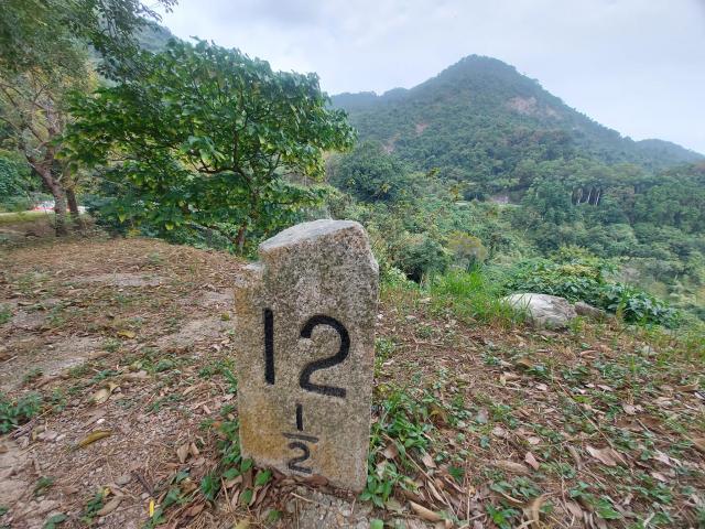
Refering to Gerry's question about if it is double-sided, yes it is, the MS has two sides. One side (facing Tai Po) is 44 while the other (facing Ma Liu Shui) is 12.5. On the TPR, all of them are like this because it is a circular route.
thanks Ryan, yes, I see where it is now and the background does make sense to me. I remember wandering along here many years ago and never spotting any of the old milestones even though I was looking for them. But at the time I hadn't realised that the road had been straightened here a little bit to remove the kink so had walked right past it.
With regards to the straightening of the road, I suspect it is because the old route was too close to the edge of the slope and it was moved away to prevent accidents or landslips.
Comments
Never seen it before
I have never seen MS44 before even when I took the bus... very interesting. On the 2001 map, there is no MS44, so I wonder if this was taken in the 90s or older.
MS 44 TPR
You mentioned MS 44, but the pic shows 12 1/2. Is this a double sided MS?
MS 44?
It's a while since I was up there, but if this is #44 then the background makes no sense to me. I don't think it is #44.
MS 44
So you posted a pic of 12 1\2 MS. Where did you see it?
I think
If you look at 1975 map of https://www.hkmaps.hk/mapviewer.html, you can see the road was with more curves then. MS 44 placing is slightly weird on the map because it dented up a little. On the dent is MS 44. If you chose 1963.2 (aerial), you will see that the MS is actually very close to the edge than the road is, hence the photo is correct.
I have so many questions though. When they rebulid the road so it's straighter (assume MS44 is still here), why they didn't dismantle it?
Yes
Refering to Gerry's question about if it is double-sided, yes it is, the MS has two sides. One side (facing Tai Po) is 44 while the other (facing Ma Liu Shui) is 12.5. On the TPR, all of them are like this because it is a circular route.
MS 44
thanks Ryan, yes, I see where it is now and the background does make sense to me. I remember wandering along here many years ago and never spotting any of the old milestones even though I was looking for them. But at the time I hadn't realised that the road had been straightened here a little bit to remove the kink so had walked right past it.
With regards to the straightening of the road, I suspect it is because the old route was too close to the edge of the slope and it was moved away to prevent accidents or landslips.
Found it on Google Maps
https://www.google.com.hk/maps/@22.4197259,114.1969135,3a,15y,65.37h,88.16t/data=!3m6!1e1!3m4!1sZHk5_b4hwdo8mM3VQmgArA!2e0!7i16384!8i8192?hl=en
If you look closely, you can see the number 4 (the No. 44). Date is 10/2020.
because the milestone is not
because the milestone is not located in the roadside
yes
yes
yes, that why the ms is not
yes, that why the ms is not located in the roadside.
Photos 20/06/2021