Current condition
Ruin
Date completed
(Day, Month, & Year are approximate.)
Learned about it from a few online sources, also Mr. Cracknells blog as I recall. Went and looked through it this summer. Figured I would add it here. It is reasonably long, going through a ridge I think, 2 exits and a somewhat long side tunnel as I remember. One exit overlooks the reservoir.
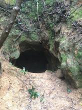
The main access point is right off the staircase leading up from the crossroads of Mt. Parker road/Boa vista track. it is only about 50 or so meters up the staircase just past a power station. The entrance is large and obvious.
Photos that show this Place
????
Comments
I did go inside the tunnel
Its' quite long inside, and many branches, Just keep left and you can go out again!
Quote "it is only about 50 or
Quote "it is only about 50 or so meters up the staircase just past a power station"
Pylon or station? I am only able to locate the former in the satellite photo ...
I mean pylon in the subtitle.
I mean pylon in the subtitle.
Tunnel
Large tunnel, might I add
Any one knows why is the structure that way?
I was wondering why they dug the "negative" pillar structure. Extra lateral holing in a kind of pillar form in some of the corridors. Pic for reference. Really sturdy looking structure overall.
To see it all we needed to crawl a bit. Really nice big one.
Been there yesterday
Been there yesterday afternoon, went in through the larger entrance, only had to bend down for a while. But crawled out through the small one near the said"shrine".
Haven't explored the whole place, only took one route. It's been a hurry for us having to visit several interesting sites in one day.
Structural Support
@hkoutdooradventures are you referring to the 'pillar' shaped dugout sides of the tunnel? All of these tunnels originallly had wooden support beams, which is reflected in the structural patterns you see in the tunnels today.
I see some users commenting on the size. I would suspect that this tunnel is not actually much more than an OP/infantry defense position due to the substantially larger tunnel complexes (along HK island) from Mt. Collision & Sai Wan battery, through Mt. Butler & JLO & WNC Gap, all the way over to Mathilda hospital (plus a smattering of small tunnels along those areas).
Regards
Thanks for the input!
Thanks for the input!
Beans was the only conclusion that we get to, also. I was a bit confused of not seeing any remainder, as I am used to seeing them in the old mines. Tungsten mines for example, 1935-1967, with worse humidity conditions still keep them. Most are very damaged, but you can see them all around. I do not know if those extra 2 decades would make them disappear completely or anyone took them out from this tunnel.
Regarding the size. Big in its current condition and as one piece. I have been in all you mentioned and I think now they are smaller either cause some of the connections collapsed or were built in separated units relatively close one to each other. Next year I will try to take some time to measure and draw some extra maps of this one, Sai Wan Battery, JLO East big one and any other interesting.
Mapping tunnels
Several years ago I tried using "structure from motion" to convert a video taken when walking through a tunnel into a 3D model of that tunnel. It failed miserably, as the combination of poor lighting, low resolution, and the uniform appearance of the tunnel walls meant the computer wasn't able to match up the frames from the video to build its model. (I had better luck with some photos of the old KCR clocktower).
The latest Apple iPADs and iPhones include LIDAR sensors, and apps are being developed that use them to make a much more powerful 3D-scanning solution. (eg see this video of using Apple LIDAR to map a room: https://youtu.be/F8kutn1Xu-U).
If anyone has the chance to use LIDAR to map a tunnel, please leave a link to your model so we can admire it!
Map of Tunnel
My friend and I measured out the entire tunnel. It is about 210 meters total with 4 entrances/ exits. Let me know if anyone wants a map.
Would you post the map here
Would you post the map here please?
I've only been to two of the exits, and am wondering if there's another one on the other side of the shrine like structure, ie, the dead end of the tunnel. Cos when I looked up, there seemed to be a collapsed exit. I haven't explored the other branch yet.
Pls share
Hi, would love to see map of the tunnel and learn how you measured it.
How can you share it?
Thanks Mike
A video of traversing the whole tunnel (4 entrances/exits)
Starting from the entrance below the electric tower, I followed the left branch and walked clockwise (The tunnel would have been a circle if the right branch went further to connect the fourth exit) to reach the fourth exit/entrance. Two other entrances/exits appear in the middle. From the outside, you may find the fourth entrance very close to the electric tower.
(I walked left. When there was a three-way junction, I always turned left first, reaching a dead end/exit before returning. After the fourth exit, I went along the main path back to the first entrance and to the right branch.)
The right branch might be a short side tunnel, can't find obvious evidence of exit/entrances.