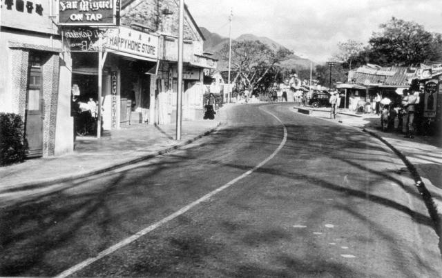
Jim described this photogaprh as being taken from the Sweet Garden restaurant, probably the building on the extreme left, which is clearly a restaurant. Can anyone read the sign? Next to it is the Happy Home Store that Jim thinks was owned by a lady called Princess. (Andrew S)
I have just flipped the image and the sign immediately below the 'San Nuguel On Tap' notice definitely reads 'Sweet Garden Bar'
Date picture taken
1960s
Gallery
Shows place(s)
Comments
I think the building at the
I think the building at the left was an ancestral hall opposite to the Tsz Tong Tsuen
Origianl image of above Illustration
Origianl image of above illustration, a aerial View of Kam Tin
Thank you terewong.
Thank you terewong.
The aerial view fits well with several of my friends' descriptions of the Sweet Garden Restaurant and the Happy Home Store being fairly close to the Walled village, and the bend in the road matches quite nicely with that on Jim Macfarlane's photograph. I agree with you that the tall gable end of the building, which is apparently just beyond the Happy Home Store, on Jim's photograph also matches well with the one on the aerial photograph.
I hadn't realised that there was another walled and moated village almost opposite the one that we all visited! Were they owned by rival clans?
Regards Andrew
There are two walled village
There are two walled villages close to each together, one is Tai Hong Wai and the other one is Kat Hing Wai which is famous to the tourists, besies, there is one more walled village next to Tai Hong Wai called 'Wing Lung Wai'.
Thank you terewong. Would it
Thank you terewong. Would it have been normal for there to be so many individual clan(?) walled villages so close together? In England, villages would normally be much more widely separated. Regards, Andrew
Bill Connell's photograph, below, shows how close to the Kam Tin walled village the Happy Home Store and the Sweet Garden Restaurant were. I'll adjust the pin on the map. Andrew
In 1955, it was Sweet Garden Restaurant, but in 1960...
The building to the far left of the photo was a restaurant, not an ancestral hall. Yet it no longer beared an English name as "Sweet Garden Restaurant" as shown in the 1955 photo of the same location. Instead it had a Chinese name: "珍(?)香園餐..." Maybe the owner changed it to a Chinese name (the meaning is very similar to the English one) or there was a new owner and thus a new restaurant. In fact, the entrance area had been completely changed.
It was an ancestral hall and
It was an ancestral hall and later its outer part change into a commercial purpose as shops because it close to the walled village, Kat Hing Wai, which attracts lots of tourists during 50s to 80s also the army stationed at Shek Kong, Hog Kong.
I think you are right, the Chinese name might be 珍香園
Hi Andrew,
Hi Andrew,
In Kam Tin, almost all villages or walled villages belong to Tang's clan, the people come from the same family in the past.
Thank you terewong and
Thank you terewong and Stanislaus for clarifying things. I hadn't realised that the different walled villages were actually owned by different 'sub families' within the Tang clan. Was Kam Tin unique in having so many walled villages or did Yuen Long also have several?
After much checking of the different photgraphs showing the Sweet Garden Restaurant building I think that I finally inserted the pin in the correct place on the map. If not, please let me know and I'll move it.
Best wishes, Andrew
Ancestral hall in Kam Tin
Hi terewong, what was the name of the ancestral hall and why was it converted to commercial use? When was it demolished? I checked Google Maps and it is no longer there. Thank you.
not only in Kam Tin, but also
not only in Kam Tin, but also the other parts of Yuen Long, there are many villages, some with walls, some without wall. Most of the villages were developed initially without wall, later they build walls and gates to protect themselves and the harvest etc from pirate.
鄧屐敬祖
鄧屐敬祖
鄧屐敬祖
Thank you, terewong. I cannot find any information through Google. Is there more resources I can look at to learn about this ancestor of the Tang clan and the hall named after him? Also, is there any photograph before the hall was converted to shops? Thank you.
Address for Sweet Garden Restaurant
Found an address. Sweet Garden Restaurant and Bar was located at 210 Main Road, Kam Tin. San Mig on tap!
Sweet Garden restaurant.
Thanks Moddsey,
As I only visited Kam Tin specifically to see the walled village once or maybe twice in 1958, I never went to the Sweet Garden restaurant or the shop next to it. Both were well patronised by the R.A.F's 367 Signals Unit personnel, who were billeted at R.A.F. Sek Kong while working at Kong Wei. Jim McFarlane's gallery and perhaps others in the 367 Gallery show them and also a Cafe de Paris which was I believe fairly close to the Sweet Garden Restaurant. Kam Tin was not a big place. All the photographs from the 1950s show that stretch of the Main Road had quite a pronounced bend in it which, now that the road has been straightened, made pinpointing the site difficult. However, Google Earth Street view shows that a modern building now occupies the whole of the site of those traditional buildings. I wonder if they too bear the number 210. Wow, San Mig on tap! I only ever knew it as a bottled beer. Andrew
Re: Sweet Garden Restaurant and Bar
Yes, the captioned restaurant and bar and those next to it were popular watering holes for servicemen. On the original photo, a "San Mig" on tap signboard can be seen at top left. Cheers!
1954 Kam Tin Road
Thanks Moddsey, This is the
Thanks Moddsey, This is the same building as on Jim Mcfarlane's photograph in the 367 Gallery, but taken from the opposite dfirection. The area of ground being cleared and swept is the same spot as in the centre of Jim's photograph. By 1960, when Jim took the photograph, it looks as though it might have been developed as a garden(?), which could be where the Sweet Garden restaurant was in his day.
On the other hand he has a photograph taken in the gateway to the Cafe de Paris (Kam Tin) which shows a pillar beside the gateway that used to appear on an earlier edition of Google Earth Street View. That site has once again been redeveloped as you will see on an up to date Google Earth Street View. I suspect that there were several cafes, bars and restaurants in that short stretch of road and, confusingly, they could have changed their names.
Regards, Andrew
Kam Tin Town
We moved to a village near Kam Tin a few years ago. Whilst walking through the town one day not long afterwards, I was intrigued to see a sign opposite to Kat Hing Wai pointing to “Shing Mun Sui Tong San Chuen” - Shing Mun Reservoir New Town.
It didn’t take the detective skills of Sherlock Holmes to deduce that this village was originally comprised of people who had been displaced when the Jubilee, (now Shing Mun), Reservoir was constructed in the 1920s/30s. I always thought that those people were rehoused in the Sheung Shui / Fanling areas. Many were, (according to an information board placed at the northern end of the reservoir), but some, obviously, were relocated to Kam Tin.
My enquiries revealed that the newcomers lived in harmony with the Kam Tin residents, although apparently there was a language gap as the newcomers spoke a completely different dialect!
Thank you for the…
Thank you for the interesting observation. I guess that even the small children who were displaced will by now be old people, but perhaps they might have memories of living in that remote valley. Maybe, if contactable, they could supply Gwulo with some interesting memories.
Kam Tin Aerial View 1963
Thank you Paulo. An aerial…
Thank you Paulo. An aerial photograph in the excellent book, 'Hong Kong in Old Times' (aerial photos taken in 1964) shows that the pond on the North side of the road to the North East of the Kam Tin walled village had been filled in by then, so I wonder whether this image might be earlier than 1963. The R.A.F. is unlikely to have taken aerial photographs in two consecutive years. If your date is correct it suggests that the book includes photographs from several years rather than the stated, 1964. Any thoughts?
The building with its two gable ended roofs, clearly visible on the North side of the bend near the Eastern edge of the photograph, was the Happy Home stores and the Sweet Garden restaurant (see photos earlier in this thread). The Kam Tin Theatre had yet to be built on the vacant lot to the west of them - maybe even where the pond had been? There are only two vehicles on the road but the one on the extreme East intrigues me. It is the shape and size of a bus and with its white roof it reminds me very much of the R.A.F. buses that were sometimes used to carry personnel on off-duty trips. Andrew
1960s Sweet Garden Restaurant
Complements the main photo submitted by Andrew. Commercial slide, early 1960s.
On the Kam Tin Road showing the Sweet Garden Restaurant and Shing Kee Restaurant at the rear. Nice spot to stop by for a San Miguel on tap.
Sweet Garden Restaurant
Thanks Moddsey for another good photograph that shows even more of the building. The red car on the left looks very much like an MGB sports car and the small one on the right is probably a Fiat 500, both of which were current throughout the 1960s. Regards, Andrew