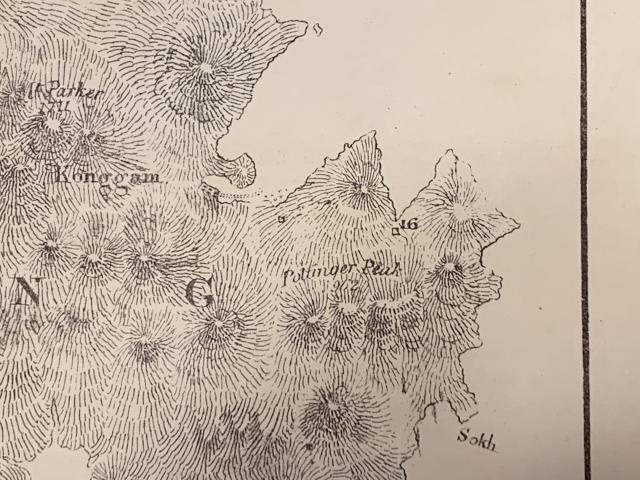
I was very surprised to see a number 16 at the western end of the Little Sai Wan bay on this map. The key indicates that it was a military station. In 1845 that area would have been very isolated and, to my mind, of no strategic importance, as being a long way from the harbour and nowhere near any villages. There were no ruins there in the 1950s, although a 1845 structure could have disappeared if built with wood. On another of the maps there is a 17 - again out in the wilds possibly somewhere near 'Ty tam /Ty cam' (?) which might be Tai Tam. Number 18 is at Aberdeen and that is likely to be accurate. Has anyone got any thoughts on this? Andrew
You are right Andrew. My English great great granduncle was in Hong Kong as part of the Royal Sappers and Miners from 28th June 1845 until 27th December 1850 so I am interested in the military going-ons during this time period (I have very niche topics of interest!). I don't have any documentation of where he was based whilst in HK (the surviving military records are incomplete) but he survived his busy stint in the unhealthy enviornment of early Hong Kong (although he later drowned in the South China Sea en route to Canton in November 1859 after having survived the Crimean War 1854-56, Malta earthquake of 12th October 1856 and Indian Mutiny of 1857). As part of my research of looking through records and newspapers I have come across these mentions.... some excerpts from Briitsh newspapers (the bold highlights are mine):
"....The extreme eastern and western parts of Victoria are composed of Chinese streets and bazaars, where articles and curiosities essentially Chinese are to be found, as well as those of European origin or manufacture. Some few villages are distributed over the island, but Chuck-choo, a military station on the southern side, is the largest, the population of which does not amount to seventeen hundred. Sai-Wan, a smaller village on the east, is also occupied as a military station and sanitorium for our troops, the native population of which does not amount to five hundred..."
Source: The Sun, London, page 6, Saturday Evening 12th May 1849
"Including all diseases, the deaths in the 95th Regiment since the 12th of June have been 106; in the Rifles the total casualties have been only 6.
The following table exhibiting the number of men and officers in the garrison, and the extent of sickness of every description in the different corps, shows a gratifying improvement during the past week. The entire force is stationed at Hong Kong, with the exception of 62 Ceylon Rifles at Chek-chu and 26 at Sai-wan. We are unable to say what proportion of the 226 and 294 sick is to be set down to the present epidemic:
Thank you for your very interesting comments, David. I did wonder, when I saw this map, whether number 16 had been mis-placed. The larger bay to the West of Little Sai Wan, with its very distinct small 'island' connected to the mainland by a spitof sand, is of course what we now call Chai Wan. In 1957/8, it still stood out very distinclty as you can see on my photograph. I believe that the wooded hill still exists although it is now surrounded by tall blocks of flats. Some of my later photographs suggest that is the case. As far as I can remember other posts have identified the old Victorian military camp as being somewhere on the slope beyond the island/hill. The map does show two rows of about six huts in that area, but if accurately placed these earlier huts would have been on a site slightly to the left of this 1958 photogaph.
Chai Wan from Cape Collinson Road, by Andrew Suddaby
I think that the military station is already pinned onto the map but perhaps David could do the honours if it is not. Another photograph in the 367 Association gallery was taken by Bill Weild in 1952. Below, it shows that there was another camp in the pass where the Island Eastern Corridor runs just to the North of what is now the Lyemun Holiday camp. Even though the photograph shows what look like Nissen huts, I suspect that this camp might be older than the Lyemun camp. I don't know how old it was but a roofless circular building on this photograph has been identified as possibly being a gunpowder store - which suggests that that camp dates from the mid Victorian era. Clearly, after 1845, camps were re-sited for health and strategic reasons. Some of this is speculation and I welcome clarification from others with more knowledge than I have!
Regards Andrew
Lyemun Gap and Devil's Peak 1952 b., by Bill Weild
Comments
16
I was very surprised to see a number 16 at the western end of the Little Sai Wan bay on this map. The key indicates that it was a military station. In 1845 that area would have been very isolated and, to my mind, of no strategic importance, as being a long way from the harbour and nowhere near any villages. There were no ruins there in the 1950s, although a 1845 structure could have disappeared if built with wood. On another of the maps there is a 17 - again out in the wilds possibly somewhere near 'Ty tam /Ty cam' (?) which might be Tai Tam. Number 18 is at Aberdeen and that is likely to be accurate. Has anyone got any thoughts on this? Andrew
Military installation at Sai Wan (1st Generation)
You are right Andrew. My English great great granduncle was in Hong Kong as part of the Royal Sappers and Miners from 28th June 1845 until 27th December 1850 so I am interested in the military going-ons during this time period (I have very niche topics of interest!). I don't have any documentation of where he was based whilst in HK (the surviving military records are incomplete) but he survived his busy stint in the unhealthy enviornment of early Hong Kong (although he later drowned in the South China Sea en route to Canton in November 1859 after having survived the Crimean War 1854-56, Malta earthquake of 12th October 1856 and Indian Mutiny of 1857). As part of my research of looking through records and newspapers I have come across these mentions.... some excerpts from Briitsh newspapers (the bold highlights are mine):
"....The extreme eastern and western parts of Victoria are composed of Chinese streets and bazaars, where articles and curiosities essentially Chinese are to be found, as well as those of European origin or manufacture. Some few villages are distributed over the island, but Chuck-choo, a military station on the southern side, is the largest, the population of which does not amount to seventeen hundred. Sai-Wan, a smaller village on the east, is also occupied as a military station and sanitorium for our troops, the native population of which does not amount to five hundred..."
Source: The Sun, London, page 6, Saturday Evening 12th May 1849
"Including all diseases, the deaths in the 95th Regiment since the 12th of June have been 106; in the Rifles the total casualties have been only 6.
The following table exhibiting the number of men and officers in the garrison, and the extent of sickness of every description in the different corps, shows a gratifying improvement during the past week. The entire force is stationed at Hong Kong, with the exception of 62 Ceylon Rifles at Chek-chu and 26 at Sai-wan. We are unable to say what proportion of the 226 and 294 sick is to be set down to the present epidemic:
Present force. Sick, Aug 26. Sick, Aug 19.
Artillery...........................................................42 ............ 8 ............ 9
Sappers and Miners 25 ........... 3 ............ 2
Gun Lascars................................................. 77 ............ 14 ................ 12
95th Regiment..............................................470 .............. 112 .............. 170
Ceylon Rifles.................................................535 ................. 89 ................ 101
------ ------ -------
1149 226 294"
Source: London Evening Standard, page 4, 27th October 1848
Maybe David or yourself want to create a Gwulo place page for this so as we find more info we can build up a better understanding?
Thank you for your very
Thank you for your very interesting comments, David. I did wonder, when I saw this map, whether number 16 had been mis-placed. The larger bay to the West of Little Sai Wan, with its very distinct small 'island' connected to the mainland by a spitof sand, is of course what we now call Chai Wan. In 1957/8, it still stood out very distinclty as you can see on my photograph. I believe that the wooded hill still exists although it is now surrounded by tall blocks of flats. Some of my later photographs suggest that is the case. As far as I can remember other posts have identified the old Victorian military camp as being somewhere on the slope beyond the island/hill. The map does show two rows of about six huts in that area, but if accurately placed these earlier huts would have been on a site slightly to the left of this 1958 photogaph.
I think that the military station is already pinned onto the map but perhaps David could do the honours if it is not. Another photograph in the 367 Association gallery was taken by Bill Weild in 1952. Below, it shows that there was another camp in the pass where the Island Eastern Corridor runs just to the North of what is now the Lyemun Holiday camp. Even though the photograph shows what look like Nissen huts, I suspect that this camp might be older than the Lyemun camp. I don't know how old it was but a roofless circular building on this photograph has been identified as possibly being a gunpowder store - which suggests that that camp dates from the mid Victorian era. Clearly, after 1845, camps were re-sited for health and strategic reasons. Some of this is speculation and I welcome clarification from others with more knowledge than I have!
Regards Andrew