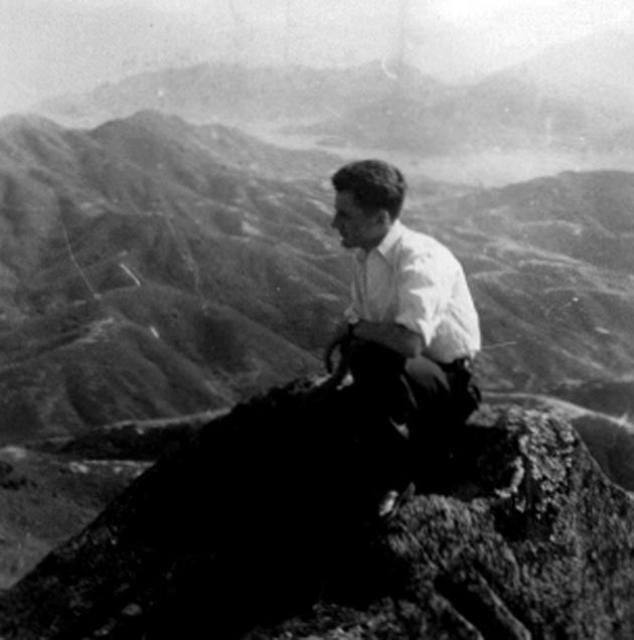
Apologies for the poor image, but somebody might be able to identify where this photograph was taken. At first I thought it might be on Mt Parker, but this hill top is too far from the sea. I now think that the distant hills perhaps look more like those near Shek O placing the location somewhere near the Tai Tam reservoir. Any thoughts?
Date picture taken
1 Sep 1953
Gallery
Shows place(s)
Comments
Maybe Lion Rock?
Hi Andrew, during this covid19. lockdown period have been down memory lane looking thro the 1950s photos on Gwulo again, including your extensive collection of 1950s photos from the R.A.F. 367 association. This photo of myself taken during April 1957 sitting on a large boulder when climbing Lion Rock, although taken from a slightly different angle does have similarities with the photo of Chris. Lewis, sadly the distant views on both photos are very blurred, maybe we are both sitting on the same boulder?. Stay safe, Best Regards, Bryan.
Hi Bryan,
Hi Bryan,
Like you I have also been trawling through many of the nostalgic photographs on David's site. Before going further, I have to say that over the last year or two I have really enjoyed seeing Hong Kong from your perspective. We both clearly shared an interest in seeing as much of that strange world as possible and recording it on film. I concentrated on Kodachrome but it was very expensive and so slow that photography was really restricterd to sunny days. When short of cash I used monochrome but then I made the mistake of developing the films and printing from them in the dark room at Little Sai Wan. I had several disasters with the developing (not being able to get the water cool enough) and quite a few interesting rolls of film were basically wiped out. Knowing of the great interest in Hong Kong's WWII ruins, I also regret not taking photogaphs of all the pill boxes and bunkers that were still in clear view in 1957/8. I guess the reason was that I was so used to seeing so many old pill boxes around where I grew up in East Yorkshire, those in H.K. had no novelty value.
Now, to the two photographs. I was tempted to believe that they might have been taken in the same locality on Lion Rock, but viewed from the opposite angle. However, if that were the case, on Chris. Lewis' photograph we would probably see the Kai Tak runway and/or the Lyemun Strait, with the distant hills on the left being those around Little Sai Wan but, while possibe, none of these things really fits. Chris was billeted briefly at the old Army camp at Cape Collinson, then briefly at Lyemun and finally at Little Sai Wan. I think that it is very unlikely that he would have climbed Lion Rock. For some years I was the historian for the 367 Association and nobody ever mentioned doing that climb - but Mt Parker and possibly Mt Buttler would have been 'next door' to Lymun camp. I do know that several members had walked from Lyemun to Big Wave Bay via Mt Parker and the Tai Tam Tuk reservoir area - hence my thoughts that Chris was posing on a rock somewhere in that area. However, I cannot reconcile the sea and distant hills on the photograph with my own knowledge of the terrain from wandering in that area in the early 2000s. Perhaps some of the Hong Kong residents will sort it all out for us!
I've always said that Hong Kong in the 1950s was the best posting in the R.A.F. - and I suspect that you would say the same thing for the Army.
Best wishes, keep your head down and stay safe, Andrew
Kowloon Reservoir (is it?)
Greetings. No boats or ships, and the gentleman was wearing shirt and dress pants, I think he was on a car trip not expecting to walk long distance from a road. May I suggest he was somewhere on a high spot northeast of Kowloon Reservoir (camera) looking to the southwest. Correction welcome! Regards, Peter
Perhaps taken from Kowloon Peak
Perhaps taken around Kowloon Peak looking at an undeveloped East Kowloon. Mount Parker rises on the right across the harbour with Lyemun Gap at top left. Today's view across the harbour here
Kowloon Peak
Moddsey is correct about the background, I first thought this may have been Black Hill but now I think I can see a geater resemblence from Kowloon Peak. However, from the way the headland lines up to the background, I can see a much better match from above today's Anderson Quarry area, so perhaps this was slightly closer to that area. That would make the road at the bottom Po Lam Road.
Thanks Phil
Given the attire that Chris was wearing, Anderson Road does show up in maps from the early 1950s.
Anderson Quarry
Hi Moddsey, yes, you're right it was only Anderson Road back then, but it also looks as though the hill was known as Chiu Lan Chu and had a "3rd class cart track" leading up from the Clearwater Bay Road side all the way to the summit at 418m. I guess getting to the top in white shirt and trousers was possible back then. I guess the track disappeared when the place was quarried. I'd hazard a guess that the spot Chris was sitting on no longer exists because it looks like the quarrying went further than the location of the old summit.
1963 aerial view
If you zoom in on the centre of this image there is a good candidate for the rock close to the end of the cart trail: https://www.hkmapservice.gov.hk/OneStopSystem/map-search/getPreviewFile?itemId=DAP&sheetNo=1963-5880
Thank you Phil, Moddsey,
Thank you Phil, Moddsey, Peter and Bryan. My reservations about the Chris Lewis photograph showing Lyemun Strait, Mt Parker and the hills around Little Sai Wan were wrong! I had thought that the hills behind Little Sai Wan looked too low to be right and I could not understand why Kai Tak, etc., were not visible but, if as you suggest the photograph was taken from Kowloon Peak (further to the East of Lion Rock), that would explain the latter. The added colour photograph of the group on Kowloon Peak clearly shows the outline of the hills up behind Chai Wan and Little Sai Wan. I am still rather puzzled why and how Roy Gilliams and Chris Lewis went all the way round to Kowloon Peak, at a time when trraveling was still quite difficut in the early 1950s. So, Bryan, it looks as thogh it was not the same rock - just a very similar one. Regards, Andrew
not Kowloon peak
Hi Andrew
Actually, I'm saying this isn't Kowloon Peak but even further east above what is now Anderson Road Quarry. The old aerial photo I linked to shows a definite track that went all the way up to the summit from Clearwater bay Road, so it would have been a relatively easy job to get up there compared to today.
Cheers
Phil
Google Earth View
Hi Andrew - can play and adjust the view here on google earth.
Above Anderson Road Quarry
Hi Phil, Peter and Moddsey
I have looked at the area above the Anderson Quarry on Google Earth and agree that, lining it up with the image of Chris Lewis on Roy Gilliam's photograph, that must be where you suggest. In confirmation and against all the odds I have found a telephone number for Roy and have just spoken with him. He confirms that he took the photograph somewhere on the hills where you suggest - but, after about 66 years he cannot be certain which hill it was! The view certainly encompasses, Mt Parker at the extreme right and Devil's Peak, the Lyemun Strait and, in the far distance, the hills above Little (Siu) Sai Wan Now we should try to add a pin to the 1952 map. Any suggestions? Can one of you do that or do I have to make a good guess?
The other image of Roy sitting on a boulder was, as I thought, taken on the Eastern side of Pottinger Peak with the Nissen huts and Caves of Camp Collinson just visible in the background.
Regards Andrew
place
Hi Andrew
I have created a new place under its current name (Tai Sheung Tok) but have no idea how long this name has been in vogue. It doesn't appear on the 1957 map. As I mentioned earlier, I believe the old summit and the rock Chris was sitting on has been quarried away.
Cheers
Phil
East Kowloon - view from high ground
Great finding phil and moddsey! The size of the water body should have ruled out a reservoir my suggestion. For any person including myself who may be shown alone in this wilderness, the memory is one to cherish. Andrew, look what your photos have done and are still doing to readers! Regards, Peter
Good detective work everyone.
Good detective work everyone. I got the impression from my brief telephone conversation with Roy Gilliams earlier today that, as a Corporal, he occasionally had to spend the odd day at the R.A.F. units at Sek Kong and maybe Shatin. In that case he would have driven in one of the Land Rovers and could possibly have travelled along the Clearwater Bay road. As Chirs is wearing civilian clothes it's likely that Roy was also not in uniform - but I suspect that he would still have had access to a vehicle.
From what Phil has written I suspect that Roy could have driven up that unclassified road more or less to the spot where the photograph was taken. I'm probably way off the mark!
The pleasure that others receive in seeing and discussing all these photographs makes uploading them worthwhile. And just imagine what we should all have missed without David's wonderful website. Well done David! Andrew
"I suspect that Roy could
"I suspect that Roy could have driven up that unclassified road more or less to the spot where the photograph was taken."
I think you are spot on. It looks like the track was good enough for a vehicle (especiqally a land rover) and it explains why Chris still looks quite fresh and dapper despite being at the top of a hill.
Thanks for the probable
Thanks for the probable confirmation Phil. Corporals and their pals enjoyed the high old life (literally in this case) compared with the rest of us who had to slog everywhere on foot. Andrew
Tai Sheung Tok
Photos of Tai Sheung Tok and Anderson Quarry here A similar photo to the original appears on Page 3.
Hi Moddsey. Thank you for
Hi Moddsey. Thank you for pointing to the spectacular photographs from Skywalker. If Roy and Chris stood on that actual summit they would have enjoyed great views. On my return visits to H.K. in the early 2000s I visited Devil’s Peak but never the hills further to the West, and I never even climbed Lion Rock. Andrew