Current condition
Ruin
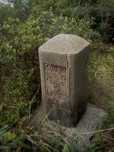
I found this stone on Beacon Hill today; and the obvious question is: what is this? The markings are heavily weathered, though in the short time I had to look at it I could make up the number "1902", I guess that's the year the stone was created.
Location: N 22° 20.875 E 114° 10.110, just off Lung Yan Road.

Photos that show this Place
2012
2022
Comments
Re: Marker Stone
That's an interesting one - I don't remember seeing that style before.
If I zoom in to the photo, it looks as though there is "PWD" across the top and "No. 2" (digit is a guess) along the bottom. That suggests it was erected by the Public Works Department and is one of several stones marking out the boundary of a piece of land.
I'm not sure about the middle number. A lot number perhaps?
Other marker stones we've seen from the early 1900s were cut from granite, not made from concrete like this one, so I guess it was later than 1902.
Then what was it for? Something connected with the Beacon Hill railway tunnel?
Regards, David
PS I've changed this page to a 'Place' so we can show it's location. Please edit it and drag the marker to the right location if I'd put it in the wrong place.
Re: Marker Stone
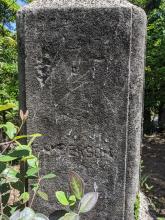
Concrete indeed, which explains the serious weathering. I quite accidentally ran into that stone, and really no idea what it could be.
Looking at the original photo (not that zoomify thing) I think the bottom is indeed "No 2".
The numbers 1902 suggest a year but could be something totally different of course. IIRC only one side had lettering (on the photo). But I did it a bit in a rush.
Thanks for making it "place". My first submission here... I submitted it using GPS coordinates; may not be spot-on but the thing is hard to miss. It's placed next to the road, on top of a narrow ridge. I think the road is dug out a bit at that place.
Marker stone
could it be related to the service reservoirs that are up that road? Or is it further up the road than that (i.e. past the fencing next to the turnoff for the reservoir)
Re: Marker
Hi there,
Found this in The Trigo Man's albumn earlier, filed under Trigonometrical stations. Don't even know if it is something similar.
Worth a look though.
Best Regards,
T
Kowloon Reservoir Boundary Stones
This is one of the bs I have been looking for. Most of them can be found around Kowloon Reservoir and its vicinity, except a few like this which are located far from it for unknown reason ... Maybe someone can tell me
I have visited all existing, except #1-5, 7+8. Not sure if I have found #18 for it's not that legible but the location is somewhat correct.
#15 maybe demolished for there is a building at that place now.
Do you have a map with the
Do you have a map with the locations of the other stones?
Could it be a demarkation of the catchment area of the reservoirs? That seems consistent with the location of this one, but I have no idea where the others could be.
If it belongs to the reservoir, then 1902 is the year?? Construction of the reservoir started 1907 so exploration must have been done before that.
Re: Stone Marker
Perhaps related to the Kowloon Waterworks. Para: 54 of the 1902 PWD Report refers. Large concrete pillars were established to define the drainage area of the storage reservoir under construction and the intakes above Cheung Sha Wan.
Kowloon Reservoir Boundary Stones
Correct. Most of them are located around the above mentioned reservoir and those nearby, except #1-8, which are either located on Piper's Hill and Beacon Hill... though most of them (#3-5, 7+8) are still without their location made known.
Is there a page for this type of bs in this site, like those for the location of pb?
Is there a page for this type of bs in this site?
"Is there a page for this type of bs in this site..."
sorry, I have nothing to add but this made me chuckle a bit. I think the confinement is getting to me.
Phil
re: Kowloon Reservoir Boundary Stones
I've added the tag Kowloon Reservoir Boundary Stones to this Place. If you create Places for the other stones you've found, and give them the same tag, they'll be shown on this map: https://gwulo.com/taxonomy/term/15150/places-map
#2
Been there today, this is #2. Seems to be at the boundary of the drainage area.
KWW No. 6 Boundary Stone
I came across number 6 at the weekend, at the top of Piper's Hill:
1933 Reference to Kowloon Water Works Boundary Stone
Rambles over Kowloon Peninsula Hills - See here