A contract for the completion of the Main and Byewash Dams of the Storage Reservoir was entered into with the Kang On Firm in January and was completed on the 1st December. The work done included :
Cement Concrete: 1,000 cubic yards
Lime Concrete:3,100 cubic yards
Ashlar Masonry:21,300 cubic feet
Rubble:730 cubic yards
With the completion of this contract, the Kowloon Waterworks Gravitation Scheme, authorized in December 1901, (aide Sessional Papers Nos. 50/1901 and 27/ 1902), was brought to a close and it may be of interest to give here a brief account of the works executed.
The Scheme, as carried out, included the following works:
(i.) A Storage Reservoir of 374 million gallons capacity with a natural drainage area of 438 acres.
(ii) A Caretaker’s Bungalow.
(iii) Two Catchwaters, one intercepting the drainage of an area of 400 acres and the other of an area of 28 acres.
(iv.) A Clearwater Channel.
(v.) A Main from the Storage Reservoir to the Filter Beds.
(vi) Three Filter Beds having a total area of 2,400 square yards.
(vii) A Main from the Filter Beds to the Service Reservoir.
(vm) A Service Reservoir of 2,183,000 gallons capacity.
(ix.) A Main from the Service Reservoir to Yaumati and sundry extensions of the distribution system in Kowloon Peninsula.
(x.) Miscellaneous works.
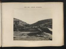
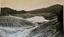
(i) Storage Reservoir.—This has been formed by the construction of a main dam across the valley of the Lai Chi Kok stream a little beyond the 5-mile stone on the Tai Po Road and an overflow dam in a depression to the South of the main dam. Both dams are constructed of masonry and concrete.
The main dam is curved on plan with. a radius of 240 feet. Its length. on top is 600 feet, its height from the lowest part of the foundation to the top 112 feet and its maximum thickness 72 feet.Four draw-offs, fitted with the necessary valves, are provided at the levels of 375, 395, 415 and 435 feet above Ordnance Datum respectively, (permanent overflow level being 448 feet above Ordnance Datum), and are connected with a 10" cast iron stand-pipe fixed in a well which is formed in the dam. From the bottom of the well, a culvert extends to the outer face of the dam, in which are laid a 10” main which is joined up to the stand-pipe and a 12” scour pipe which served the purpose of enabling the height of the water to be controlled during construction and is now available as a washout for the reservoir.
The dam is composed almost entirely of cement concrete, faced on the inner side with granite ashlar masonry and on the outer side with granite rubble masonry. In the top 21 feet and at both ends, where the dam extends well into the hillsides, lime concrete has been substituted for cement concrete. Immediately behind the ashlar masonry of the inner face, cement concrete of special quality, (proportions 1, 1&1/2, 3), varying from 5’ 0” thick at the bottom to 2’ 0” thick at the top, has been used for the purpose of ensuring water-tightness. As an old pathway across the hills to Sheng Mun and Tai Po crossed the site of the reservoir and therefore became submerged, it was necessary to make other provision for it and this has been done by forming a path, 9 feet Wide, on top of the dam, which is at a level of 454 feet above Ordnance Datum.
The following are the quantities of material used in the construction of the dam:
Cement concrete:36,740 cubic yards.
Lime concrete:4,420 cubic yards
Ashlar masonry: 64,520 cubic feet.
Rubble: 1,750 cubic yards.
The overflow dam is l40 feet long and 23 feet high from the lowest part of its foundation to overflow level, the path already referred to being carried across it on a bridge 9 feet wide supported on granite ashlar piers. The overflow comprises 10 openings, each 10 feet wide, all of which are provided with iron sluices, by means of which an additional depth of 2 feet of water in excess of that held up by the dam can be impounded. Below the overflow dam are two “water cushions ” to break the fall of the water and beyond them a channel, varying in width from 120 feet to 60 feet, has been cut for a distance of 300 feet and lined with concrete and masonry. Clockwork recording gear has been provided to register the extent of any
overflow which may occur.
In addition to the provision made for it in the case of the two dams, the diversion of the old pathway necessitated the formation of 1&1/2 miles of new path, varying in Width from 6 feet to 4 feet. It consisted merely of a cutting in the hillside of the width stated with the necessary cross drains where required.
The construction of the reservoir also entailed raising the level of the main road to Sha Tin and Tai Po for a distance of nearly half a mile to an average extent of 1 foot 6 inches.
(ii.) Caretaker’s Bungalow: This is built on a site within 100 feet of the Tai Po Road, where it commands a view of both the main and overflow dams of the storage reservoir. The main building contains 5 rooms, 2 bathrooms and verandahs and is designed to accommodate a caretaker and any officer whose duty may require him to reside temporarily in the locality. Suitable Servants’ quarters are also provided. With the exception of a stone base, 4 feet high, the walls are of Canton brick in lime mortar, faced with Amoy bricks. The floors of the rooms are of teakwood on hardwood joists and the floors of verandahs of cement tiles on cement concrete.
(iii) Catchwaters: The natural catchment area of the reservoir, as already mentioned, is only 438 acres, the yield from which would be insufficient to fill a reservoir of such capacity in years of low rainfall and it was therefore necessary to supplement it by means of catchwaters. The main catchwater commences near the east end of the reservoir. Passing under the Tai Po Road it is carried for a distance of 2 miles along the Northern slopes of the Kowloon range of hills, terminating at the stream which flows northward from the Lion’s Head or Kowloon Pass. It intercepts the water from an area of 400 acres and, except where crossing stream-courses, is cut entirely out of the solid. Commencing with a cutting in solid rock through a gap in the hills, it has an average width of 21 feet and depth of 7’ 6", diminishing gradually to 15 feet by 8 feet at its upper end. A small V-shaped channel is formed at one side to carry the dry weather flow; sand pits, extending the full width of the channel, are constructed at intervals of 200 feet to intercept any grit that may be carried by the water during rainstorms and overflows are provided at most of the points where any considerable streams enter the catchwater. A path, 6 feet wide, has been constructed on the outer bank of the catchwater and is carried across the overflows by concrete bridges, The bottom of the channel is lined with cement concrete 4” thick and the sides with lime concrete of the same thickness. The catchwater has a fall of 1 in 2,400 and when running full it is calculated that it will carry 20 million gallons an hour. This capacity was provided so that it may in future be extended to intercept the water from a further area of 600 acres, or 1000 acres in all, and it is designed to carry a rainfall of 1” per hour from the last-mentioned area. A clockwork recorder has been provided to register the depth
of the Water flowing in the catchwater.
The second catchwater, which is 500 feet long, with a sectional area of 7 square feet, intercepts a stream with a drainage area of 28 acres near the Caretaker's Bungalow and discharges into the Reservoir at the Byewash Dam.
(iv) Clearwater Channel: To avoid drawing water from the Reservoir when, after heavy rains, it may be too turbid to be easily filtered, a channel has been constructed to intercept a portion of the flow from the Catchwater in addition to the Waters of a natural stream and convey them into the main leading to the filter beds This channel extends from the Catchwater to the overflow dam, contouring the hills on the South side of the reservoir and just above top water level. It is 2,000 feet in length, has a sectional aroa of 2& ½ square feet and a fall of 1 in 1,200 and is lined throughout with concrete, the bottom being of cement and the sides generally of lime concrete. Where spurs of the hill would cause any considerable detour, they have been out through, 15" stoneware pipes being laid to conduct the water between the points where the channel ends. An intake has been formed in the bed of the catchwater from which the water is conveyed in 12” cast iron pipes into the channel and the waters of the stream already mentioned are intercepted in a similar manner. From the Overflow Dam, where the channel terminates, the water is conveyed in an 8" cast iron pipe, which passes through the dam, crosses the Overflow Channel in a diagonal line and extends down the hillside to the main gauge basin on the pipe-line leading to the Filter Beds.
(v) Main from Storage Reservoir to Filter Beds: - As already mentioned, the 10” stand-pipe, with which the draw-off pipes from the reservoir are connected, is continued by a main of the same diameter through the culvert in the main dam, whence it extends down the gorge for a distance of 800 feet to an open gauge basin.From this point an 18"’ cast iron main is laid at a gradient of 1 in 1,000 to another gauge basin at the filter beds, a distance of 3,200 feet below the main dam. The main is carried down the right bank of the Lai Chi Kok stream for a distance of 1,400 feet and then, turning nearly at right angles, it crosses the stream on a bridge of steel girders and stone piers and passes through a spur of the hills in a tunnel 356 feet long constructed on the “cut and cover” system finally discharging into the gauge basin at the filter beds. A branch on this main has been provided so that water may, when necessary, be passed to the Filter Beds at Lai Chi Kok from which the supply for the shipping is drawn. The tunnel already mentioned is 6' 0" high and 7’ 6” wide, space being provided in it for another line of 18” pipes when found necessary. It is lined throughout with brick in cement 18” thick.
(vi) Filter Beds: These are situated immediately below and to the North of the gap in the Kowloon range of hills, through which the Tai Po Road passes. A considerable amount of excavation had to be done in levelling the site for them. The beds are three in number, each 105’ 0” x 70’ 0”, giving a total area. of 2,400 square yards. They are formed of lime concrete, finished with cement rendering round the sides and with a layer of cement concrete on the bottom. The filtering material consists of 3’ 6” of sand on 1 foot of broken stone. The water is drawn off through adjustable outlets, by means of which its level may be maintained constant, and passes through Venturi meters which record both the rate of flow and the filtering head. The levelling of the site, which will accommodate 3 more beds of the same size as those already described, entailed excavation to the extent of 83,000 cubic yards. The work included the erection of a small stone building to accommodate 3 coolies employed as caretakers.
(vii) Main from Filler Beds to Service Reservoir: Immediately after leaving the Filter Beds, the main enters a tunnel 802 feet long, thus avoiding a long detour round the Western end of the ridge which terminates at Lai Chi Kok. This tunnel is of the same dimensions as the one already described but, as the main portion of it has been out through hard rock, only the ends are lined with 18” brickwork in cement. Gn leaving the tunnel, the main follows a track which has been out on the hillside so as to enable it to be laid on the “hydraulic gradient” of l in 1,000, till the Tai Po Road is reached at a point close to the 4 mile stone. From here it is laid in the road until it reaches the meter-house at Kowloon Tong, whence it is carried direct to the Service Reservoir. Where it crosses stream beds, the main is carried by steel joists on stone piers, provision being made for its duplication when required. From the Filter Beds to the Service Reservoir the distance is 2&1/3 miles, of which 3,100 feet consist of 1.8” pipes at a gradient of I in 1,000 and 9,300 feet of 12” pipes having a “hydraulic gradient ” of 5 in 1,000.
(viii) Service Reservoir: Thle Service Reservoir is built on the summit of a hill to the north of Kowloon Tong Village. lt is circular in plan with a top diameter of 155’ 0” and depth of 20' 0". The bottom and circumferential wall are of cement concrete and the roof of cement concrete vaulting supported on brick arches and stone piers. The capacity of the reservoir' is 2,183,000
gallons and its top water level is 255’ above Ordnance Datum.
(ix) Main From Service Reservoir to Yaumati etc: From the meter-house at Kowloon Tong, where the total supply is measured and recorded by a Venturi meter, a 12" main is carried along the Tai Po Road and Shanghai Street to Yaumati where it connects with the old distribution system at the Yaumati pumping station now disused. A 6” branch main is taken off it en route and is laid generally along the boundary line of British Kowloon to Kowloon City and another branch main, 5” diameter, to Taikoktsui and Sham Shui Po. The extensions of the distribution system.included an 8” main from the Yaumati Theatre along Gascoigne Road to Hunghorn, the substitution of 7” and 6” mains for the old 4” in Canton Street, Salisbury and Chatham Roads and part of Austin Road and sundry 4” mains in various parts of the peninsula where no mains existed previously. Ball fire hydrants were fixed on the mains in -all developed areas and street fountains were provided where required. The extensions and enlargements of the distribution system etc comprise in all 7 miles of new mains, 3 miles of substituted mains of larger diameter, 158 Fire Hydrants and 65 Street Fountains.
(x.) Miscellaneous: This is comprised the election of 32 concrete boundary pillars on the hills to demarcate the catchment area; the construction of temporary intakes on the streams crossing the Tai Po Road to augment the supply to the peninsula while the new works were under construction; the laying of a temporary main at Yaumati for the same purpose ; the cutting of a road from Cheung Sha Wan gap to the bay to give general access to the works: the erection of a temporary bamboo pier in the bay; payment of the Engineers’ commission and part of the overseer’s salary and also compensation to the villagers for land which was thrown out of
cultivation by the works.
Cost of Scheme: The following is a statement of the cost of the various works included under the scheme
(i) Storage Reservoir:$622,499.48
(ii) Caretakers Bungalow:$18,478.24
(iii). Catchwaters:
-Main Catchwater 2 miles long: $161,468.64
-Second Catchwater 500 feet long $2,400$163,868.64
(iv,) Clearwater Channel:$7231.00
(v.) Main from Storage Reservoir to Filter beds$60,723.35
(vi) Filter Beds$68,496.40
(vii) Main from Filter Beds to Service Reservoir$65,745.61
(viii.) Service Reservoir$67,639.31
(ix.) Main from Service Reservoir to Yaumati and
sundry extensions of Distribution System$74,490.05
(x.) Miscellaneous Works
(a) Engineers‘ Commissions: $63,724.47
(b) Compensation for land
thrown out of cultivation: $4,755.16
(c) Pier in Cheung Sha Wan
Bay: $1,000.00
(d) Boundary Pillars demarcating
Catchment area: $576.00
(e)Temporary Intakes above Tai Po
Road and temporary main at
Yaumati, etc., to augment supply
during construction of new
Works: $4,845.28
(f) Overseer's Salary: $5214.00
(g) Sundries: $8,536.16
$88,678.07
Total Cost:$1,237,850.15
There is still a balance of $11,292.43 due to the Kang On firm in connection with item (i), but this amount, is included in the above statement and a credit of $18.00 for unused stores which have to be returned has also been allowed for. There are also of certain matters in connection with Mr. Tsang Keng’s contract for items (i) and (ii); which are at present the subject of arbitration and the figures given for those items have to be altered when the award is made.
Execution of Scheme: The whole of the works described above were designed and supervised on behalf of the Government by Messrs. Denison, Rem & Gibbs. The reasons for entrusting the work to this firm were the inadequacy of the staff of the Public Works Department and the fact that Mr. Gibbs, whilst occupying the position of Assistant. Engineer in the Public Works Department, prior to joining the firm mentioned, had investigated and reported upon the possible sources from which it supply of water for Kowloon Peninsula could be obtained, the scheme in question being evolved from his report.
The underground 'service reservoir' mentioned above under (viii) seems to be the same one that is currently being demolished (although the process has been halted for the time being).

Comments
Kowloon Waterworks Gravitation Scheme
A contract for the completion of the Main and Byewash Dams of the Storage Reservoir was entered into with the Kang On Firm in January and was completed on the 1st December. The work done included :
Cement Concrete: 1,000 cubic yards
Lime Concrete: 3,100 cubic yards
Ashlar Masonry: 21,300 cubic feet
Rubble: 730 cubic yards
With the completion of this contract, the Kowloon Waterworks Gravitation Scheme, authorized in December 1901, (aide Sessional Papers Nos. 50/1901 and 27/ 1902), was brought to a close and it may be of interest to give here a brief account of the works executed.
The Scheme, as carried out, included the following works:
(i.) A Storage Reservoir of 374 million gallons capacity with a natural drainage area of 438 acres.
(ii) A Caretaker’s Bungalow.
(iii) Two Catchwaters, one intercepting the drainage of an area of 400 acres and the other of an area of 28 acres.
(iv.) A Clearwater Channel.
(v.) A Main from the Storage Reservoir to the Filter Beds.
(vi) Three Filter Beds having a total area of 2,400 square yards.
(vii) A Main from the Filter Beds to the Service Reservoir.
(vm) A Service Reservoir of 2,183,000 gallons capacity.
(ix.) A Main from the Service Reservoir to Yaumati and sundry extensions of the distribution system in Kowloon Peninsula.
(x.) Miscellaneous works.
(i) Storage Reservoir.—This has been formed by the construction of a main dam across the valley of the Lai Chi Kok stream a little beyond the 5-mile stone on the Tai Po Road and an overflow dam in a depression to the South of the main dam. Both dams are constructed of masonry and concrete.
The main dam is curved on plan with. a radius of 240 feet. Its length. on top is 600 feet, its height from the lowest part of the foundation to the top 112 feet and its maximum thickness 72 feet.Four draw-offs, fitted with the necessary valves, are provided at the levels of 375, 395, 415 and 435 feet above Ordnance Datum respectively, (permanent overflow level being 448 feet above Ordnance Datum), and are connected with a 10" cast iron stand-pipe fixed in a well which is formed in the dam. From the bottom of the well, a culvert extends to the outer face of the dam, in which are laid a 10” main which is joined up to the stand-pipe and a 12” scour pipe which served the purpose of enabling the height of the water to be controlled during construction and is now available as a washout for the reservoir.
The dam is composed almost entirely of cement concrete, faced on the inner side with granite ashlar masonry and on the outer side with granite rubble masonry. In the top 21 feet and at both ends, where the dam extends well into the hillsides, lime concrete has been substituted for cement concrete. Immediately behind the ashlar masonry of the inner face, cement concrete of special quality, (proportions 1, 1&1/2, 3), varying from 5’ 0” thick at the bottom to 2’ 0” thick at the top, has been used for the purpose of ensuring water-tightness. As an old pathway across the hills to Sheng Mun and Tai Po crossed the site of the reservoir and therefore became submerged, it was necessary to make other provision for it and this has been done by forming a path, 9 feet Wide, on top of the dam, which is at a level of 454 feet above Ordnance Datum.
The following are the quantities of material used in the construction of the dam:
Cement concrete: 36,740 cubic yards.
Lime concrete: 4,420 cubic yards
Ashlar masonry: 64,520 cubic feet.
Rubble: 1,750 cubic yards.
The overflow dam is l40 feet long and 23 feet high from the lowest part of its foundation to overflow level, the path already referred to being carried across it on a bridge 9 feet wide supported on granite ashlar piers. The overflow comprises 10 openings, each 10 feet wide, all of which are provided with iron sluices, by means of which an additional depth of 2 feet of water in excess of that held up by the dam can be impounded. Below the overflow dam are two “water cushions ” to break the fall of the water and beyond them a channel, varying in width from 120 feet to 60 feet, has been cut for a distance of 300 feet and lined with concrete and masonry. Clockwork recording gear has been provided to register the extent of any
overflow which may occur.
In addition to the provision made for it in the case of the two dams, the diversion of the old pathway necessitated the formation of 1&1/2 miles of new path, varying in Width from 6 feet to 4 feet. It consisted merely of a cutting in the hillside of the width stated with the necessary cross drains where required.
The construction of the reservoir also entailed raising the level of the main road to Sha Tin and Tai Po for a distance of nearly half a mile to an average extent of 1 foot 6 inches.
(ii.) Caretaker’s Bungalow: This is built on a site within 100 feet of the Tai Po Road, where it commands a view of both the main and overflow dams of the storage reservoir. The main building contains 5 rooms, 2 bathrooms and verandahs and is designed to accommodate a caretaker and any officer whose duty may require him to reside temporarily in the locality. Suitable Servants’ quarters are also provided. With the exception of a stone base, 4 feet high, the walls are of Canton brick in lime mortar, faced with Amoy bricks. The floors of the rooms are of teakwood on hardwood joists and the floors of verandahs of cement tiles on cement concrete.
(iii) Catchwaters: The natural catchment area of the reservoir, as already mentioned, is only 438 acres, the yield from which would be insufficient to fill a reservoir of such capacity in years of low rainfall and it was therefore necessary to supplement it by means of catchwaters. The main catchwater commences near the east end of the reservoir. Passing under the Tai Po Road it is carried for a distance of 2 miles along the Northern slopes of the Kowloon range of hills, terminating at the stream which flows northward from the Lion’s Head or Kowloon Pass. It intercepts the water from an area of 400 acres and, except where crossing stream-courses, is cut entirely out of the solid. Commencing with a cutting in solid rock through a gap in the hills, it has an average width of 21 feet and depth of 7’ 6", diminishing gradually to 15 feet by 8 feet at its upper end. A small V-shaped channel is formed at one side to carry the dry weather flow; sand pits, extending the full width of the channel, are constructed at intervals of 200 feet to intercept any grit that may be carried by the water during rainstorms and overflows are provided at most of the points where any considerable streams enter the catchwater. A path, 6 feet wide, has been constructed on the outer bank of the catchwater and is carried across the overflows by concrete bridges, The bottom of the channel is lined with cement concrete 4” thick and the sides with lime concrete of the same thickness. The catchwater has a fall of 1 in 2,400 and when running full it is calculated that it will carry 20 million gallons an hour. This capacity was provided so that it may in future be extended to intercept the water from a further area of 600 acres, or 1000 acres in all, and it is designed to carry a rainfall of 1” per hour from the last-mentioned area. A clockwork recorder has been provided to register the depth
of the Water flowing in the catchwater.
The second catchwater, which is 500 feet long, with a sectional area of 7 square feet, intercepts a stream with a drainage area of 28 acres near the Caretaker's Bungalow and discharges into the Reservoir at the Byewash Dam.
(iv) Clearwater Channel: To avoid drawing water from the Reservoir when, after heavy rains, it may be too turbid to be easily filtered, a channel has been constructed to intercept a portion of the flow from the Catchwater in addition to the Waters of a natural stream and convey them into the main leading to the filter beds This channel extends from the Catchwater to the overflow dam, contouring the hills on the South side of the reservoir and just above top water level. It is 2,000 feet in length, has a sectional aroa of 2& ½ square feet and a fall of 1 in 1,200 and is lined throughout with concrete, the bottom being of cement and the sides generally of lime concrete. Where spurs of the hill would cause any considerable detour, they have been out through, 15" stoneware pipes being laid to conduct the water between the points where the channel ends. An intake has been formed in the bed of the catchwater from which the water is conveyed in 12” cast iron pipes into the channel and the waters of the stream already mentioned are intercepted in a similar manner. From the Overflow Dam, where the channel terminates, the water is conveyed in an 8" cast iron pipe, which passes through the dam, crosses the Overflow Channel in a diagonal line and extends down the hillside to the main gauge basin on the pipe-line leading to the Filter Beds.
(v) Main from Storage Reservoir to Filter Beds: - As already mentioned, the 10” stand-pipe, with which the draw-off pipes from the reservoir are connected, is continued by a main of the same diameter through the culvert in the main dam, whence it extends down the gorge for a distance of 800 feet to an open gauge basin.From this point an 18"’ cast iron main is laid at a gradient of 1 in 1,000 to another gauge basin at the filter beds, a distance of 3,200 feet below the main dam. The main is carried down the right bank of the Lai Chi Kok stream for a distance of 1,400 feet and then, turning nearly at right angles, it crosses the stream on a bridge of steel girders and stone piers and passes through a spur of the hills in a tunnel 356 feet long constructed on the “cut and cover” system finally discharging into the gauge basin at the filter beds. A branch on this main has been provided so that water may, when necessary, be passed to the Filter Beds at Lai Chi Kok from which the supply for the shipping is drawn. The tunnel already mentioned is 6' 0" high and 7’ 6” wide, space being provided in it for another line of 18” pipes when found necessary. It is lined throughout with brick in cement 18” thick.
(vi) Filter Beds: These are situated immediately below and to the North of the gap in the Kowloon range of hills, through which the Tai Po Road passes. A considerable amount of excavation had to be done in levelling the site for them. The beds are three in number, each 105’ 0” x 70’ 0”, giving a total area. of 2,400 square yards. They are formed of lime concrete, finished with cement rendering round the sides and with a layer of cement concrete on the bottom. The filtering material consists of 3’ 6” of sand on 1 foot of broken stone. The water is drawn off through adjustable outlets, by means of which its level may be maintained constant, and passes through Venturi meters which record both the rate of flow and the filtering head. The levelling of the site, which will accommodate 3 more beds of the same size as those already described, entailed excavation to the extent of 83,000 cubic yards. The work included the erection of a small stone building to accommodate 3 coolies employed as caretakers.
(vii) Main from Filler Beds to Service Reservoir: Immediately after leaving the Filter Beds, the main enters a tunnel 802 feet long, thus avoiding a long detour round the Western end of the ridge which terminates at Lai Chi Kok. This tunnel is of the same dimensions as the one already described but, as the main portion of it has been out through hard rock, only the ends are lined with 18” brickwork in cement. Gn leaving the tunnel, the main follows a track which has been out on the hillside so as to enable it to be laid on the “hydraulic gradient” of l in 1,000, till the Tai Po Road is reached at a point close to the 4 mile stone. From here it is laid in the road until it reaches the meter-house at Kowloon Tong, whence it is carried direct to the Service Reservoir. Where it crosses stream beds, the main is carried by steel joists on stone piers, provision being made for its duplication when required. From the Filter Beds to the Service Reservoir the distance is 2&1/3 miles, of which 3,100 feet consist of 1.8” pipes at a gradient of I in 1,000 and 9,300 feet of 12” pipes having a “hydraulic gradient ” of 5 in 1,000.
(viii) Service Reservoir: Thle Service Reservoir is built on the summit of a hill to the north of Kowloon Tong Village. lt is circular in plan with a top diameter of 155’ 0” and depth of 20' 0". The bottom and circumferential wall are of cement concrete and the roof of cement concrete vaulting supported on brick arches and stone piers. The capacity of the reservoir' is 2,183,000
gallons and its top water level is 255’ above Ordnance Datum.
(ix) Main From Service Reservoir to Yaumati etc: From the meter-house at Kowloon Tong, where the total supply is measured and recorded by a Venturi meter, a 12" main is carried along the Tai Po Road and Shanghai Street to Yaumati where it connects with the old distribution system at the Yaumati pumping station now disused. A 6” branch main is taken off it en route and is laid generally along the boundary line of British Kowloon to Kowloon City and another branch main, 5” diameter, to Taikoktsui and Sham Shui Po. The extensions of the distribution system.included an 8” main from the Yaumati Theatre along Gascoigne Road to Hunghorn, the substitution of 7” and 6” mains for the old 4” in Canton Street, Salisbury and Chatham Roads and part of Austin Road and sundry 4” mains in various parts of the peninsula where no mains existed previously. Ball fire hydrants were fixed on the mains in -all developed areas and street fountains were provided where required. The extensions and enlargements of the distribution system etc comprise in all 7 miles of new mains, 3 miles of substituted mains of larger diameter, 158 Fire Hydrants and 65 Street Fountains.
(x.) Miscellaneous: This is comprised the election of 32 concrete boundary pillars on the hills to demarcate the catchment area; the construction of temporary intakes on the streams crossing the Tai Po Road to augment the supply to the peninsula while the new works were under construction; the laying of a temporary main at Yaumati for the same purpose ; the cutting of a road from Cheung Sha Wan gap to the bay to give general access to the works: the erection of a temporary bamboo pier in the bay; payment of the Engineers’ commission and part of the overseer’s salary and also compensation to the villagers for land which was thrown out of
cultivation by the works.
Cost of Scheme: The following is a statement of the cost of the various works included under the scheme
(i) Storage Reservoir: $622,499.48
(ii) Caretakers Bungalow: $18,478.24
(iii). Catchwaters:
-Main Catchwater 2 miles long: $161,468.64
-Second Catchwater 500 feet long $2,400 $163,868.64
(iv,) Clearwater Channel: $7231.00
(v.) Main from Storage Reservoir to Filter beds $60,723.35
(vi) Filter Beds $68,496.40
(vii) Main from Filter Beds to Service Reservoir $65,745.61
(viii.) Service Reservoir $67,639.31
(ix.) Main from Service Reservoir to Yaumati and
sundry extensions of Distribution System $74,490.05
(x.) Miscellaneous Works
(a) Engineers‘ Commissions: $63,724.47
(b) Compensation for land
thrown out of cultivation: $4,755.16
(c) Pier in Cheung Sha Wan
Bay: $1,000.00
(d) Boundary Pillars demarcating
Catchment area: $576.00
(e)Temporary Intakes above Tai Po
Road and temporary main at
Yaumati, etc., to augment supply
during construction of new
Works: $4,845.28
(f) Overseer's Salary: $5214.00
(g) Sundries: $8,536.16
$88,678.07
Total Cost: $1,237,850.15
There is still a balance of $11,292.43 due to the Kang On firm in connection with item (i), but this amount, is included in the above statement and a credit of $18.00 for unused stores which have to be returned has also been allowed for. There are also of certain matters in connection with Mr. Tsang Keng’s contract for items (i) and (ii); which are at present the subject of arbitration and the figures given for those items have to be altered when the award is made.
Execution of Scheme: The whole of the works described above were designed and supervised on behalf of the Government by Messrs. Denison, Rem & Gibbs. The reasons for entrusting the work to this firm were the inadequacy of the staff of the Public Works Department and the fact that Mr. Gibbs, whilst occupying the position of Assistant. Engineer in the Public Works Department, prior to joining the firm mentioned, had investigated and reported upon the possible sources from which it supply of water for Kowloon Peninsula could be obtained, the scheme in question being evolved from his report.
Source: PWD Report 1910 (No 102)
Kowloon Reservoir Boundary Stones
Is there any map with the locations of #1,3,4,5,7,8 ?
Service reservoir
The underground 'service reservoir' mentioned above under (viii) seems to be the same one that is currently being demolished (although the process has been halted for the time being).
See: https://hongkongfp.com/2020/12/29/in-pictures-demolition-halted-amid-ca…; and
https://www.scmp.com/news/hong-kong/society/article/3115589/hong-kong-a…;
Kowloon Reservoir declared monuments
Five structures at Kowloon Reservoir have 'declared monument' status under the Antiquities and Monuments Ordinance:
- the main dam
- the main dam valve house
- the spillway dam
- the spillway dam recorder house
- the recorder house
There is no mention of the underground service reservoir (see earlier comment) having protected status under the AMO.
Links to photos and plans on the Antiquities and Monuments Office website: https://www.amo.gov.hk/en/monuments_91.php
Kowloon Reservoir Boundary Stones
Have you found any of them on a map? I passed a marker stone with :
KWW
902
No 14
Only #1,3,4,5,7,8 are not
Only #1,3,4,5,7,8 are not found yet, all others found.