Current condition
Ruin
Date completed
Year completed is: Approximate
Condition at last visit: Intact
Date of last visit: Feb-1995
Ref: ROB-00564
Other: Slight damage
Photos that show this Place
1997
2020
2020
Comments
Attempted visit 26 May 2013.
I couldn't find this one.
It is shown to be close to a trail. Walking a bit up that trail until reaching a dam in the stream (start of the catchwater) I found an overgrown but surfaced trail heading in the direction of where the pillbox should be, followed that, it ended at a small concreted flat area.
From there I just bushwhacked through the dense vegetation to <7m from the coordinates indicated in this node, in a few different attempts. No trace of the pillbox though.
How accurate are those coordinates, anyway?
PB 314, and coordinates
Message from Rob, and a request for better coordinates if anyone visits with a good GPS:
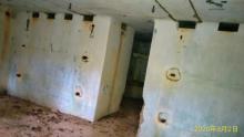
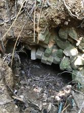
For PB 314, an alternate approach is from Golden Hill Road. Above the road level, on the PB side of the road, and approximately below the PB, is a marker stone with PB 314 and an arrow. Heading in that direction should bring you to the front of the PB, if you can get through the vegetation. The PB can be accessed through the loopholes with difficulty. It cannot be entered from the entry tunnel as it has collapsed.
As to the accuracy of the co-ordinates: you might note that most of the dates of my recording are early to mid 1990's, well before the advent of personal GPS as we know them in phones and cameras now. I used map grids from the HK 1:5000 series by standing on the PB and aligning myself with the world. When I started this project on Gwulo, I used those grids in the web transformation tool, producing the Lat and Long figures shown. In the cases of no longer existing PB's, I did have some grids from maps used by the Army at the time the PB's were built. Unfortunately these had to be converted first into modern grids, then to Lat and Long. The probability of error expands with the number of conversions, so they are not perfect. I will be happy to correct any errors if forwarded.
New coordinates
New coordinates for PB314
50Q 206484E 2475508N
re: New coordinates
Good to see a photo of this PB - thanks for uploading. If possible, please could you let me know the coordinates as decimal lat / lon, and I'll update the position of the marker. The current values are 22.359638, 114.150001
Re: New coordinates
To be honest I am still questioning about the exact location of 314. I found this structure at the hillside next to the Golden Hill Rd. The approximate decimal coordinates are 22.360425 , 114.150059. However, the location of this structure is different from the direction as the GDL slab mentioned. Next time I will follow the arrow on the direction slab and go to the current marker to observe whether there is something that I have missed before.
Thanks for the background
Thanks for the background info. I'll wait for your update before altering the marker's coordinates.
Coordinates
My record on cellphone for the captioned is 50QKK0649275510
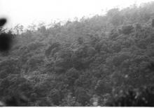
It's located on a knoll beside the Golden Hill Rd, with the entrance on its west near the junction of a path and a catchwater.
Perhaps if the accuracy of coordinates is not that exact, then with the description of some features, the type of terrain and the direction the pillbox is on that terrain, it may help while looking for such.
PB 314
I have repositioned PB 314 based on the two sets of coordinates given. This places it further along Golden Road than my original estimate. Apologies to those who have blundered through the vegetation unnecessarily.
Any good descriptions on how to get there?
I have tried to find this PB 3/4 times, all with no luck. I always followed the PB direction arrow, but always ended up in thick vegetation. The coordinates will be a great help, but is there any other descriptions you can provide Mr. H Lo?
PB 314
Like to try another way? This is the way I originally found it in 1993.
Starting from Tai Po Road, follow Golden Hill Road. At a position (roughly) 22.332172 114.141187, there is/was a rough track on the left side of the road. It is roughly 100 m before you get to the Marker for PB 314. Follow the track, which basically parallels Golden Hill Road, for (again roughly) 150 m. The path continues in the same direction, but there is/was an off shoot track on the right, which parallels the first path, but slightly higher on the hillside. Follow that and you should find the entrance to the tunnel to 314. It is only open a short distance and then is blocked. Go above the entrance and follow the collapsed parts of the tunnel on the hillside. You should eventually end up on top of the PB.
Hi Rob
Hi Rob
I see your point. That means the arrow on the slab is actually pointing towards the entrance to the PB instead of the PB itself
Do you know where is 石仙谷 with
Iloveoldhk, so do you know where is 石仙谷 with stone benches and table? There is a catchwater leading to that place, the junction of the path and the catchwater is closest to the PB entrance.
PB 314
In all probability. The tunnel is quite long, and the entrance at a guess 75m or more from the PB, so it would be reasonable to point to where you can get in. I didn't find the marker until some years after I had found the PB. There was no path near the marker at that stage.
Many Thanks
Cheers for all the responses Rob and H. Lo! Will try again soon via one of these recommendations.
Thanks to the GPS coordinates
Thanks to the GPS coordinates and the HK Hiking map app, I was able to find PB 314. The GDL slab sent me off in the wrong direction!
Easy way to find it: next to the slab is a flight of stairs. Go up them and turn right, keeping on the concrete. You'll see a red hiking ribbon - start going up the slope from there, more red ribbons marking the way. You'll soon get to the loopholes.
The arrow on the GDL is
The arrow on the GDL slab is correct. It only guides you towards to the entrance of the tunnel of PB314 but not the pillbox itself.