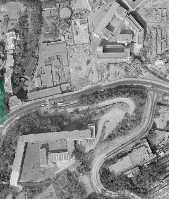
Crop from a mapping office aerial photo taken in 1963 showing the site where St Joseph's College primary School was to be built.
- Wah Yan College is bottom left.
- The looped road bottom right is Stubbs Road with Queen's Road East running across the middle from east/west.
- Top left cluster is part of Ruttonjee Hospital.
- moving right, adjacent to Ruttonjee is the old P.W.D store? (now part of Wanchai Park).
- The empty space in the centre, above Queen's Road East is the site that was to become St Joseph's College Primary.
- Building cluster on the top right is still around and consists of: the TWGH Li Chi Ho Primary School, JC Hong Chi school and to their right are the Salvation Army buildings.
Date picture taken
1 Feb 1963
Gallery
Shows place(s)
Comments
St. Joseph's College Primary
Thanks philk, another great nostalgic photo with place/building identications! Yes, it is P.W.D Store when I look at the 1957 map. I think the photo was published in 1963 showing the photo taken in 1958 or earlier. I wrote my test in 1958/59. Regards, Peter
Aerial
Hi Peter
The govt aerial photos are catalogued by the date they were taken, not published. This was the site in 1963. I can only assume you must be mistaken about the venue of your test.
Phil
St. Joseph's College Primary Site
Thank you Phil for the feedback. Several years ago when I saw the 1958 photo on the internet, I said to myself "Oh, that's where I wrote my Raimondi test (sometime in late 1958 or early 1959)". I very seldom travelled to Hong Kong. I cannot think of any trip for a different reason that would trigger the memory of these two buildings which match closely the current ones on site; the latter point convinced me they sent me to the Queen's Road East building to write the test.
I left Hong Kong in March 1964. If the aerial photo was indeed taken in 1963 showing the undeveloped site, it is my faulty memory possible after 61 years. Regards, Peter
Not a school
Among all the schools, there is the Wanchai Gasometer at the top of the photo. When checking the location of the gasometer, I found there a similar aerial photo from 1963:
aerial photo
Hi Peter, I've found the aerial photo library at the mapping office to be of utmost value when dating development of Hong Kong and even locating individual buildings, so although it's not beyond the bounds of possibility I find it very hard to believe that this particular photo (one of several from a sequence taken on the same day) should be incorrect in its dating.
Also from the school website (which echoes the comment made by Lawrence on the other thread regarding construction date).
Your description of the walk up the hill with large mansions on the way makes me think it may have been back in Central so perhaps it was at Raimondi college after all? Incidentally, if you would like to see a blurry image of that area I have some screen shots from 1960 over on my film site: https://hongkongandmacaufilmstuff.blogspot.com/2019/11/hong-kong-series-rod-taylor-1960_20.html. The very first image shows what I believe is Raimondi College in the background in an earlier form prior to the additional college buildings being constructed.
Phil
Raimondi College
Dear Phil, I am most grateful for your help, and your explanation is convincing. Both your and Klaus' 1963 photos show the Queen's Road East site still not yet developed. I found the 1958 (caption) photo on the internet (source unknown) and my brain erronously paired the building with my Raimondi test site. The year 1958 could not be verified and is now found to be incorrect.
One last detail to tie up. Exactly when was the current St. Stephen's primary building constructed? The school's web site reads in part "enabled the Brothers to put up an excellent school building and the school was officially opened on December 17, 1968." Not to contradict the statement, it does not explicitely say the building was completed in the same year. What if it occured several years yearlier? Shortly before I left HK in March 1964, I made one final walk of the area and apparently saw the same building which led to my faulty connection discussed earlier. Regards, Peter
Walk Up to Robinson Road
Back in the day, the walk-up through Central to Robinson Road may have been via Glenealy, past the Catholic Cathedral and up these flight of stairs
St Joseph's
Hi Peter
Sadly there are no images between the years 1963 and 1966 and the next set start in May of 1967 which show what looks to be site formation and nothing more. Did you make any return trips in the 70's?
Phil
Queen's Road East - St. Joseph's College Primary
Thank you Phil for your continuing support. I made my first return visit in 2014 after 50 years absence.
Earliest Raimondi students might be able to confirm where they wrote their application test. This question is still in my mind - when was the original primary building completed?
I just found a photo in Google map showing, at the current Primary School, two interior concrete columns at ground level. I once walked by two similar columns with same alignment with the walkway, also at ground level, in a very new building. Not a proof, but tempting hint to connect them with my 1958/9 Raimondi test. But we know now 1963 aerial photos prove not to be so. A case of old and erronous memory die hard! Regards, Peter