The Maclehose Trail leaves Fei Ngo Shan Road just after the junction with Jats Incline, and heads north over Tate's Ridge. Near the top of the ridge, on the north and south slopes, there are the floors and foundations of buildings.
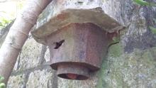
There's only one building still standing on the south side - the British knew how to build a sturdy loo!


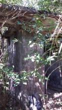
The foundations on the north look like they were for larger buildings, but the buildings themselves are all gone - they were probably wooden huts on concrete floors.

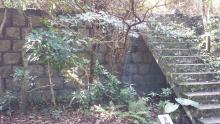
Also on the north side we can see this retaining wall, and steps up between the levels.

The remains of a cast-iron drain pipe.

The fact that the wall is made from stone not concrete makes me think the buildings probably date back to the early 20th century. Jats Incline dates to 1907:

So maybe these buildings were built around the same time?
Can anyone confirm when they were built, and what they were used for?
Regards, David
Photos that show this Place
Comments
From the pictures, you appear
From the pictures, you appear to have seen some of the remains of Tates Cairn Battery, 2 x 3.7” HAA, surprisingly built in 1949.
I’ll try to describe the area to see if it confirms where you were. I’ll assume you came up from Fei Ngo Shan Rd just above it’s junction with Jats Incline/Shatin Pass Rd. Part way up you would have passed a Japanese tunnel on the left, probably barricaded. When you reach flat ground - on concrete - to the right was a high fence which surrounds the Telecom site. From the fence a wide ramp leads up to the right, the gun road. On your left was a set of steps leading up to a flat concrete base (your photo). This is the remains of the Bty HQ. To the right of that, on the top of the rise, is a helicopter landing pad. There is a road leading from there to the base of the ramp (trust me, it’s there). If you head on the track (MacLehose Trail) towards Sai Kung, you almost immediately go down a number of concrete steps with, on the right, a series of concrete bases for huts (your photo).
Not certain about the building on the south side you refer to. I know of one, slightly below Shatin Pass Rd, which is cut into the side of a rise. It is appreciably older than the others, and I know nothing about it.
If you were in the area I described, you may have missed a real sight. In the area I would vaguely describe as being between the helicopter pad and Jats Incline is what I believe to be the CO’s residence. A small house with several rooms with a fireplace and outdoor toilet. Looks completely out of place. There is a sealed path leading back towards the HQ, but couldn’t be followed.
Google
This link gives you the Google streetview of the location.
https://goo.gl/maps/aBRjpiMsqSznaqMD8
Thanks Rob, your description
Thanks Rob, your description matches exactly so it's good to know what they were at last.
The 1952 map gives a good outline of the various buildings that were there. It'll be worth another visit to try and match the map with what's there now.