OldTimer:
In the [HKU library's "Early Hong Kong's Kowloon Peninsula" exhibition], there is a photo of Shanghai Street (thank you). It was probably the narrowest and congested street used by double-decker buses (2-way traffic at that time). These bus drivers were likely the most stressful of all their colleagues.
Before the Number 12 bus turning south onto Jordan Road, I remember there was what appeared to be an oil depot/storage place occupying an area about a small city block, with tars and oil on its ground and the air smelling asphalt/tar. I always think of that place but can't remember exactly where and its purpose. Please help and educate me on this.
David:
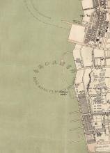
The 1902-3 map shows the block bounded by Jordan Rd, Shanghai St, Nanking St and battery St is mostly clear, but with a large circular structure on the corner of Jordan & Shanghai.
The 1924 map shows the same, but on the 1947 map there were three circular structures shown.
On the 1964 map the circular structures can no longer be seen, and the map shows there is a school on that block, the Jordan Road Government Primary School.
OldTimer:
The three circular structures must be the storage tanks I saw (and smell) in the 1950s. That their location in the midst of residential buildings has always appeared strange, but is also nostalgic when I mesmerize them. You folks are resourceful!
David:
Pg 62 of 'Early Hong Kong's Kowloon Peninsula' has a photo captioned:
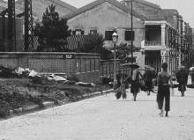
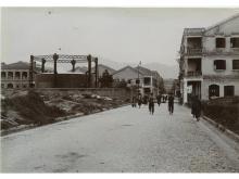
Yau Ma Tei, c. 1953. The building with pyramidal roofs (centre) is the Liberty Theatre. Opposite is the Wan Tin Teahouse. To its left at the junction of Shanghai Street and Battery Street is the gas factory.
Then at the back of the book is a map of Kowloon dated 1960, which shows the same round structures mentioned earlier, and labels the block of land as 'Gas Works'.
Moddsey:
This photo from Life shows the gas works at the corner of Shanghai St and Jordan Rd and the Admiralty oil depot. http://images.google.com/hosted/life/l?imgurl=81b1f027eb4a8c97&q=Kowloon%20source:life&prev=/images%3Fq%3DKowloon%2Bsource:life%26hl%3Den
keroseneian2003:
This was the Hong Kong & China Gas jordan Road gas works.
see upload in my flickr.


Comments
re: Jordan Rd gas Works
Kerosenian, thanks for the link and information. I enjoy seeing your photos in the 'old hong kong lovers' pool on Flickr.
tags
Hi David,
could you please add the tags "gas holder" and "gas works" so that this place appears in the list/map of gas works and gasometers.
Regards, Klaus
Demolition date
keroseneian2003 gives the following statement to Jordan Road Gas Works: the gas works was demolished in 1956.
Years of operation
By the end of the 19th century, this area was developed. HK Map Viever is a good help to follow the stages of the Jordan road gas works. In 1899, this area seems hardly developed, but on the 1901 (1901.2 to be precise) map, gas works including a gas holder are shown on I.L. No. 395, surrounded by Battery Street, Station Street, Fourth Street, and an unnamed one (later Jordan Road).
Start of operation is probably in 1900.
The 1945 map shows two round structures, the one from 1947 three. The last map with the written caption gas works in on the 1957 map. This one is based on a 1954 aerial survey "with property check in 1956". On IL 395, houses were build. Kung Sheung Mansions were first occupied by 09/1958, United Mansion by 11/1958.
End of operation is most likely end of 1956 or early 1957.
Construction date
Yau Ma Ti gas works are first mentioned in the Public Works Report for 1892:
176. Erection of Gas Lamps in British Kowloon.—The establishment of Gas Works at Yau Ma Ti by the Hongkong and China Gas Company having rendered the adoption of gas for street lighting practicable.....