With apologies for a ribald first-post, pilots at Sek Kong used, and perhaps still use Kwun Yam Shan, a hill located directly SE of the runway and near the top of Kadoorie Farm, as a topographical marker. In the mid 20th Century, the prominent volcanic plug was informally named after Jayne Mansfield, by geometric association.
The story's provenance is a day's soil sampling on the tea plantations of Tai Mo Shan in the early 1990s with Professor Charlie Grant of Hong Kong University: I believe he had some post-war service history at Sek Kong. His 1960 book, The Soils and Agriculture of Hong Kong, is a fascinating time capsule of the late-1950s New Territories
A more dignified association is that of the small shrines on Kwun Yam Shan, identified as still-active geothermal features in a recent archaeological report by Mike Atha and Kennis Yip.
Thank you Moddsey: exactly the view I'd tried to find yesterday!
The lithology (mapped by the HK Geological Survey as "rhyolitic hyaloclastite") and morphology of the feature are consistent with some form of feeder vent between subterranean magma and the various volcanic ashes and tuffs of the Tai Mo Shan area, subsequently exposed by over 160 million years of denudation.
Comments
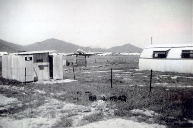
Rare Photo
A rare photo of a Dakota at Sek Kong. Thanks.
RAF News - Dakota at Sek Kong
RAF News - Dakota at Sek Kong
With apologies for a ribald first-post, pilots at Sek Kong used, and perhaps still use Kwun Yam Shan, a hill located directly SE of the runway and near the top of Kadoorie Farm, as a topographical marker. In the mid 20th Century, the prominent volcanic plug was informally named after Jayne Mansfield, by geometric association.
The story's provenance is a day's soil sampling on the tea plantations of Tai Mo Shan in the early 1990s with Professor Charlie Grant of Hong Kong University: I believe he had some post-war service history at Sek Kong. His 1960 book, The Soils and Agriculture of Hong Kong, is a fascinating time capsule of the late-1950s New Territories
A more dignified association is that of the small shrines on Kwun Yam Shan, identified as still-active geothermal features in a recent archaeological report by Mike Atha and Kennis Yip.
The 'Volcanic Plug'
The 'Volcanic Plug'
Thank you Moddsey: exactly the view I'd tried to find yesterday!
The lithology (mapped by the HK Geological Survey as "rhyolitic hyaloclastite") and morphology of the feature are consistent with some form of feeder vent between subterranean magma and the various volcanic ashes and tuffs of the Tai Mo Shan area, subsequently exposed by over 160 million years of denudation.